
| Memorials | : | 0 |
| Location | : | Mitchell, Wheeler County, USA |
| Coordinate | : | 44.4844437, -119.8994675 |
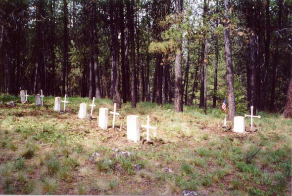
| Description | : | Cemetery is on private property and absolutely NO admittance is allowed. Information was obtained from and research. One or more burials may have been removed to other locations. The camp was named for Lieutenant Stephen Watson , who has been removed to Fort Vancouver. With a detachment of 26, he attacked a band of Paulina's men, who lay in wait for them. Watson, two other soldiers, and two scouts were killed on 18 May 1864. Their bodies were brought here for burial about 1866. The Army abandoned this camp in 1869, at which time 6 soldiers... Read More |
frequently asked questions (FAQ):
-
Where is Camp Watson Cemetery?
Camp Watson Cemetery is located at Mitchell, Wheeler County ,Oregon ,USA.
-
Camp Watson Cemetery cemetery's updated grave count on graveviews.com?
0 memorials
-
Where are the coordinates of the Camp Watson Cemetery?
Latitude: 44.4844437
Longitude: -119.8994675
Nearby Cemetories:
1. Caleb Cemetery
Mitchell, Wheeler County, USA
Coordinate: 44.5231018, -119.9383011
2. Frederic Arnecke Burial Site
Wheeler County, USA
Coordinate: 44.4740700, -119.8121100
3. Mary Waterman Burial Site
Mitchell, Wheeler County, USA
Coordinate: 44.4727402, -119.8117371
4. Spanish Gulch Cemetery
Wheeler County, USA
Coordinate: 44.4667015, -119.7722015
5. Foppiano Family Cemetery
Mitchell, Wheeler County, USA
Coordinate: 44.5954000, -119.9433000
6. Buckhorn Cemetery
Mitchell, Wheeler County, USA
Coordinate: 44.6240730, -119.7498810
7. Mitchell Cemetery Upper
Mitchell, Wheeler County, USA
Coordinate: 44.5619850, -120.1425934
8. Toney Cemetery
Mitchell, Wheeler County, USA
Coordinate: 44.6394500, -120.0818000
9. Lower Mitchell Cemetery
Mitchell, Wheeler County, USA
Coordinate: 44.5699387, -120.1636124
10. Lowrey Family Burial Site
Crook County, USA
Coordinate: 44.3641600, -120.1516200
11. Dayville Cemetery
Dayville, Grant County, USA
Coordinate: 44.4834222, -119.5748805
12. Richmond Cemetery
Richmond, Wheeler County, USA
Coordinate: 44.7311096, -119.9911118
13. Richmond Cemetery
Wheeler County, USA
Coordinate: 44.7296982, -120.0105972
14. Carroll Cemetery
Mitchell, Wheeler County, USA
Coordinate: 44.6580009, -120.2342987
15. West Branch Cemetery
Wheeler County, USA
Coordinate: 44.5341988, -120.3080978
16. Beaver Creek Cemetery
Paulina, Crook County, USA
Coordinate: 44.1847000, -119.8332977
17. John Calbreath Gravesite
Paulina, Crook County, USA
Coordinate: 44.2064500, -119.7024300
18. Aldrich Gravesite
Grant County, USA
Coordinate: 44.4528008, -119.4499969
19. Twickenham Cemetery
Twickenham, Wheeler County, USA
Coordinate: 44.7675820, -120.1990560
20. Spray Cemetery
Spray, Wheeler County, USA
Coordinate: 44.8471985, -119.8110962
21. Burnt Ranch Cemetery
Mitchell, Wheeler County, USA
Coordinate: 44.7363440, -120.3314780
22. Cummings Cemetery
Mount Vernon, Grant County, USA
Coordinate: 44.4398000, -119.3452000
23. Haystack Cemetery
Wheeler County, USA
Coordinate: 44.8800011, -119.7352982
24. Howard Cemetery
Crook County, USA
Coordinate: 44.3736000, -120.4625015