
| Memorials | : | 0 |
| Location | : | Randolph County, USA |
| Coordinate | : | 39.5952870, -92.6459750 |
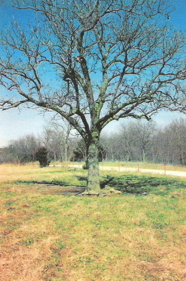
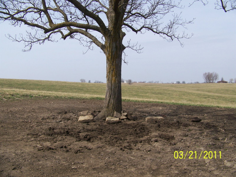
| Description | : | Located in T55 R16 S1 on the west side of CR 1185 under a lone tree just before the road curves to the east. This cemetery has been destroyed by livestock over the years. In the 1980's there were pieces of broken stones visible, but they have since disappeared. Update 2011: We probed this cemetery in March 2011 and located several bases, but no identifiable headstone pieces. |
frequently asked questions (FAQ):
-
Where is Dameron Family Cemetery?
Dameron Family Cemetery is located at Randolph County ,Missouri ,USA.
-
Dameron Family Cemetery cemetery's updated grave count on graveviews.com?
0 memorials
-
Where are the coordinates of the Dameron Family Cemetery?
Latitude: 39.5952870
Longitude: -92.6459750

Nearby Cemetories:
1. Clardy Cemetery
Randolph County, USA
Coordinate: 39.5901710, -92.6709040
2. Hebron Cemetery
Macon, Macon County, USA
Coordinate: 39.6171608, -92.6407776
3. Mount Carmel Cemetery
Clifton Hill, Randolph County, USA
Coordinate: 39.5825400, -92.6701700
4. Mount Olivette Cemetery
Darksville, Randolph County, USA
Coordinate: 39.5949170, -92.5946970
5. Kitchen Cemetery
Macon County, USA
Coordinate: 39.6164100, -92.5964000
6. Broaddus Cemetery
Darksville, Randolph County, USA
Coordinate: 39.5655550, -92.5902770
7. Marvin-Carter Cemetery
Randolph County, USA
Coordinate: 39.5957680, -92.5744400
8. Eldad Cumberland Presbyterian Cemetery
Randolph County, USA
Coordinate: 39.5380800, -92.6190800
9. College Mound Cemetery
College Mound, Macon County, USA
Coordinate: 39.6227600, -92.5749400
10. Hall Family Cemetery
Darksville, Randolph County, USA
Coordinate: 39.5613890, -92.5769090
11. Darksville Cemetery
Darksville, Randolph County, USA
Coordinate: 39.5542700, -92.5814900
12. Barnhart Cemetery
Randolph County, USA
Coordinate: 39.5731010, -92.5671997
13. Mount Shiloh Baptist Church Cemetery
Darksville, Randolph County, USA
Coordinate: 39.5534360, -92.5814940
14. Hickory Grove Cemetery
Randolph County, USA
Coordinate: 39.5402985, -92.5852966
15. Morrow Family Cemetery
Callao, Macon County, USA
Coordinate: 39.6693400, -92.6453410
16. Teter Cemetery
College Mound, Macon County, USA
Coordinate: 39.6275570, -92.5563600
17. Clarkson-Brammer Cemetery
Macon County, USA
Coordinate: 39.6707680, -92.5990880
18. Union Cemetery
Bevier, Macon County, USA
Coordinate: 39.6584100, -92.5710400
19. McCully-Haines Cemetery
Randolph County, USA
Coordinate: 39.5080870, -92.6410220
20. Johnson Cemetery
Bee Branch Township, Chariton County, USA
Coordinate: 39.6500015, -92.7369003
21. Teter-Phares Burial Site
Chariton, Macon County, USA
Coordinate: 39.6706900, -92.5780500
22. Ardmore Black Cemetery
Macon County, USA
Coordinate: 39.6456010, -92.5444840
23. Fawks Cemetery
Wayland Township, Chariton County, USA
Coordinate: 39.5264015, -92.7288971
24. Summers Family Cemetery
Huntsville, Randolph County, USA
Coordinate: 39.5439036, -92.5413740