
| Memorials | : | 0 |
| Location | : | Smithville, Clay County, USA |
| Coordinate | : | 39.3867336, -94.5214471 |
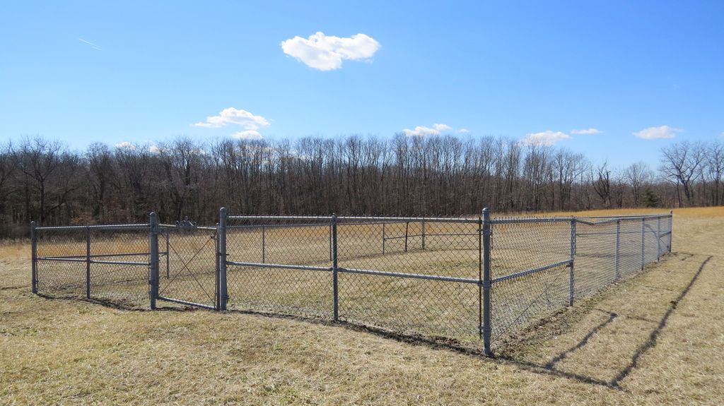
| Description | : | This cemetery is just a chain link area, with a couple of rocks inside. It has two yellow marker posts to indicate it is a cemetery. Research is ongoing to determine who is buried here. |
frequently asked questions (FAQ):
-
Where is Duncan Cemetery?
Duncan Cemetery is located at Smithville, Clay County ,Missouri , 64089USA.
-
Duncan Cemetery cemetery's updated grave count on graveviews.com?
0 memorials
-
Where are the coordinates of the Duncan Cemetery?
Latitude: 39.3867336
Longitude: -94.5214471
Nearby Cemetories:
1. Aker Cemetery
Clay County, USA
Coordinate: 39.4109955, -94.5460129
2. Paradise Cemetery
Paradise, Clay County, USA
Coordinate: 39.4244804, -94.5149307
3. Ecton Cemetery
Clay County, USA
Coordinate: 39.3807983, -94.4713974
4. Brooks Cemetery
Smithville, Clay County, USA
Coordinate: 39.3753014, -94.5699997
5. Wade-Bailey Cemetery
Clay County, USA
Coordinate: 39.4206600, -94.4935700
6. Owens Cemetery
Smithville, Clay County, USA
Coordinate: 39.3993500, -94.5719200
7. Shafer Cemetery
Smithville, Clay County, USA
Coordinate: 39.4013300, -94.5790900
8. Smithville Memorial Cemetery
Smithville, Clay County, USA
Coordinate: 39.3924713, -94.5837021
9. Watkins Cemetery
Clay County, USA
Coordinate: 39.3513985, -94.4760971
10. Rollins Family Cemetery
Clay County, USA
Coordinate: 39.4301200, -94.5556000
11. Thatcher Cemetery
Smithville, Clay County, USA
Coordinate: 39.3662400, -94.5816800
12. Mount Olivet Christian Church Cemetery
Smithville, Clay County, USA
Coordinate: 39.3320150, -94.5286950
13. Garner Cemetery
Clay County, USA
Coordinate: 39.4420600, -94.5035700
14. Davenport Cemetery
Excelsior Springs Junction, Clay County, USA
Coordinate: 39.4375000, -94.5556030
15. Corum-Judy Cemetery
Clay County, USA
Coordinate: 39.3343520, -94.5564480
16. Goss Cemetery
Smithville, Clay County, USA
Coordinate: 39.4118996, -94.5922012
17. Arley Cemetery
Kearney, Clay County, USA
Coordinate: 39.4041061, -94.4458237
18. Wood Cemetery
Smithville, Clay County, USA
Coordinate: 39.3816800, -94.6004500
19. K.M. Woods Family Cemetery
Smithville, Clay County, USA
Coordinate: 39.3397300, -94.5906400
20. Byrd Cemetery
Platte County, USA
Coordinate: 39.4151900, -94.6160800
21. Richard Simms Burying Grounds
Liberty, Clay County, USA
Coordinate: 39.3449000, -94.4310000
22. Providence Church Graveyard
Liberty, Clay County, USA
Coordinate: 39.3136101, -94.4736099
23. Pleasant Hill Primitive Baptist Church Cemetery
Trimble, Clinton County, USA
Coordinate: 39.4697495, -94.5203629
24. Mount Gilead Cemetery
Kearney, Clay County, USA
Coordinate: 39.3826942, -94.4129410