
| Memorials | : | 0 |
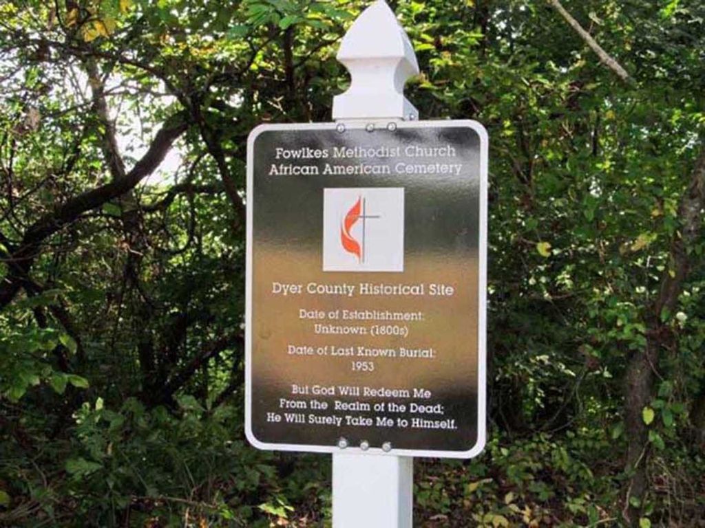
| Location | : | Fowlkes, Dyer County, USA |
| Coordinate | : | 35.9781560, -89.3996230 |
| Description | : | From the intersection of Unionville Rd. & US-51 S, S of Dyersburg at 4-Points, travel west on Unionville Rd for 0.1 mi.; turning northwest (right) onto Bend Rd., going 0.2 mi., then walk northerly about 150 yards to see if the ravine can be safely crossed, then turn southwest to the general location of this cemetery within the woods along the edge of the "Yellow Bluff" overlooking the South Fork Forked Deer River. The exact location of this 100+ year old burial site has not been documented or maintained for decades, but it has been 'deeded' in this general area.... Read More |
frequently asked questions (FAQ):
-
Where is Fowlkes Methodist Church Cemetery?
Fowlkes Methodist Church Cemetery is located at Bend Road Fowlkes, Dyer County ,Tennessee , 38024USA.
-
Fowlkes Methodist Church Cemetery cemetery's updated grave count on graveviews.com?
0 memorials
-
Where are the coordinates of the Fowlkes Methodist Church Cemetery?
Latitude: 35.9781560
Longitude: -89.3996230
Nearby Cemetories:
1. King Cemetery
Dyersburg, Dyer County, USA
Coordinate: 35.9810470, -89.3969130
2. Butterworth Cemetery
Fowlkes, Dyer County, USA
Coordinate: 35.9893990, -89.3974991
3. McCoy Cemetery
Dyer County, USA
Coordinate: 35.9536018, -89.3827972
4. Holly Springs Cemetery
Fowlkes, Dyer County, USA
Coordinate: 35.9622940, -89.3685410
5. Mount Vernon Baptist Church Cemetery
Unionville, Dyer County, USA
Coordinate: 35.9605840, -89.4342750
6. Benton-Sharp Cemetery
Fowlkes, Dyer County, USA
Coordinate: 35.9706500, -89.4404700
7. Hodge Cemetery
Dyersburg, Dyer County, USA
Coordinate: 35.9836620, -89.3532490
8. Sorrell Chapel Cemetery
Bonicord, Dyer County, USA
Coordinate: 35.9772470, -89.3458570
9. Clay Cemetery
Fowlkes, Dyer County, USA
Coordinate: 35.9760780, -89.3453920
10. Carter Cemetery
Dyersburg, Dyer County, USA
Coordinate: 36.0150440, -89.4327580
11. Pate Family Cemetery
Bonicord, Dyer County, USA
Coordinate: 35.9575110, -89.3389720
12. Poplar Grove Memorial Garden
Halls, Lauderdale County, USA
Coordinate: 35.9256840, -89.4211890
13. Dyersburg City Cemetery
Dyersburg, Dyer County, USA
Coordinate: 36.0312996, -89.3786011
14. Saint Mary's Episcopal Church Columbarium
Dyersburg, Dyer County, USA
Coordinate: 36.0335710, -89.3905220
15. Spate Cemetery
Double Bridges, Lauderdale County, USA
Coordinate: 35.9318890, -89.4396020
16. Peal and Bailey Land Cemetery
Bruceville, Dyer County, USA
Coordinate: 35.9256960, -89.3584940
17. Fowlkes Cemetery
Dyersburg, Dyer County, USA
Coordinate: 36.0303100, -89.3578170
18. Ferguson Family Cemetery
Dyersburg, Dyer County, USA
Coordinate: 36.0410400, -89.4044200
19. Green Hill Memorial Garden Cemetery
Halls, Lauderdale County, USA
Coordinate: 35.9139570, -89.3922510
20. Memorial Park Cemetery
Dyersburg, Dyer County, USA
Coordinate: 36.0358009, -89.3581009
21. Roark Family Cemetery
Dyersburg, Dyer County, USA
Coordinate: 36.0453900, -89.4050800
22. Shelton Cemetery
Fowlkes, Dyer County, USA
Coordinate: 35.9416530, -89.3281750
23. Parr Cemetery
Halls, Lauderdale County, USA
Coordinate: 35.9123900, -89.4246010
24. Williams Chapel Cemetery
Bonicord, Dyer County, USA
Coordinate: 35.9472008, -89.3221970