
| Memorials | : | 1 |
| Location | : | Dyersburg, Dyer County, USA |
| Coordinate | : | 35.9810470, -89.3969130 |
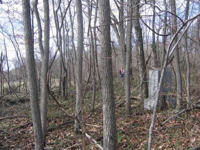
| Description | : | From the "Y" intersection of US-51 S & TN-211, south of Dyersburg, travel south on US-51 S/TN-211 for 1.5 mi., turning west (right) onto Pierce Rd., going 0.2 mi.; turning south (left) into the parking lot, once used for a church. After crops have been harvested, it is possible to see & walk about 800' south to the cemetery obscured within a small clump of trees. It is in very neglected shape and vandals have done extensive damage. Some stones are buried under years of decayed leave and soil. Two footstones have been found, with no headstone to go with... Read More |
frequently asked questions (FAQ):
-
Where is King Cemetery?
King Cemetery is located at 181 Pierce Road Dyersburg, Dyer County ,Tennessee ,USA.
-
King Cemetery cemetery's updated grave count on graveviews.com?
1 memorials
-
Where are the coordinates of the King Cemetery?
Latitude: 35.9810470
Longitude: -89.3969130
Nearby Cemetories:
1. Fowlkes Methodist Church Cemetery
Fowlkes, Dyer County, USA
Coordinate: 35.9781560, -89.3996230
2. Butterworth Cemetery
Fowlkes, Dyer County, USA
Coordinate: 35.9893990, -89.3974991
3. Holly Springs Cemetery
Fowlkes, Dyer County, USA
Coordinate: 35.9622940, -89.3685410
4. McCoy Cemetery
Dyer County, USA
Coordinate: 35.9536018, -89.3827972
5. Hodge Cemetery
Dyersburg, Dyer County, USA
Coordinate: 35.9836620, -89.3532490
6. Mount Vernon Baptist Church Cemetery
Unionville, Dyer County, USA
Coordinate: 35.9605840, -89.4342750
7. Benton-Sharp Cemetery
Fowlkes, Dyer County, USA
Coordinate: 35.9706500, -89.4404700
8. Sorrell Chapel Cemetery
Bonicord, Dyer County, USA
Coordinate: 35.9772470, -89.3458570
9. Clay Cemetery
Fowlkes, Dyer County, USA
Coordinate: 35.9760780, -89.3453920
10. Carter Cemetery
Dyersburg, Dyer County, USA
Coordinate: 36.0150440, -89.4327580
11. Dyersburg City Cemetery
Dyersburg, Dyer County, USA
Coordinate: 36.0312996, -89.3786011
12. Pate Family Cemetery
Bonicord, Dyer County, USA
Coordinate: 35.9575110, -89.3389720
13. Saint Mary's Episcopal Church Columbarium
Dyersburg, Dyer County, USA
Coordinate: 36.0335710, -89.3905220
14. Fowlkes Cemetery
Dyersburg, Dyer County, USA
Coordinate: 36.0303100, -89.3578170
15. Poplar Grove Memorial Garden
Halls, Lauderdale County, USA
Coordinate: 35.9256840, -89.4211890
16. Spate Cemetery
Double Bridges, Lauderdale County, USA
Coordinate: 35.9318890, -89.4396020
17. Ferguson Family Cemetery
Dyersburg, Dyer County, USA
Coordinate: 36.0410400, -89.4044200
18. Memorial Park Cemetery
Dyersburg, Dyer County, USA
Coordinate: 36.0358009, -89.3581009
19. Peal and Bailey Land Cemetery
Bruceville, Dyer County, USA
Coordinate: 35.9256960, -89.3584940
20. Roark Family Cemetery
Dyersburg, Dyer County, USA
Coordinate: 36.0453900, -89.4050800
21. Green Hill Memorial Garden Cemetery
Halls, Lauderdale County, USA
Coordinate: 35.9139570, -89.3922510
22. Fairview Cemetery II
Dyersburg, Dyer County, USA
Coordinate: 36.0462700, -89.3752550
23. Fairview Cemetery
Dyersburg, Dyer County, USA
Coordinate: 36.0455580, -89.3715060
24. Shelton Cemetery
Fowlkes, Dyer County, USA
Coordinate: 35.9416530, -89.3281750