
| Memorials | : | 2 |
| Location | : | Glympton, West Oxfordshire District, England |
| Coordinate | : | 51.8937150, -1.3852970 |
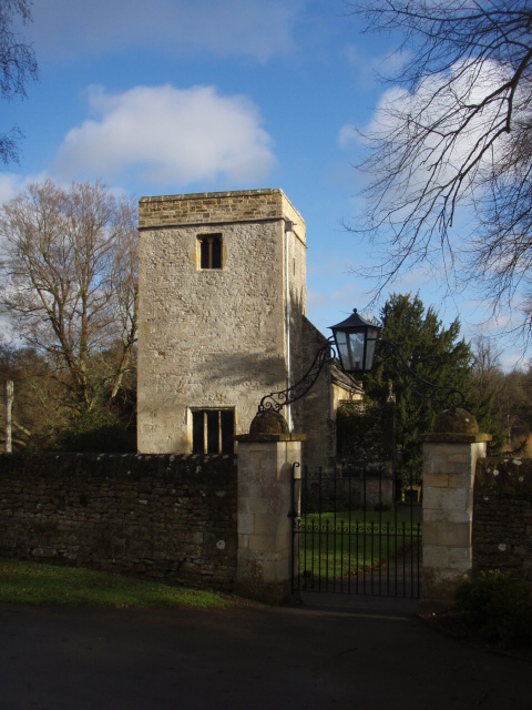
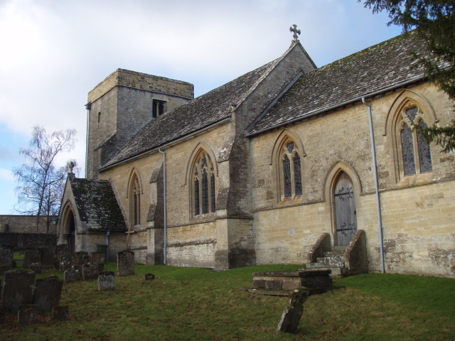
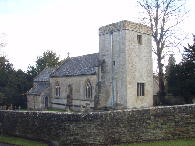
| Description | : | Manor and churchThe first known record of Glympton's existence is a charter from about AD 1050 in which it is given as a witness's address. In the reign of King Edward the Confessor, Wulfward the White, a thegn of Edward's consort Queen Edith, held the manor of Glympton. Wulfward survived the Norman conquest of England but by 1086 King William I had granted the manor to Geoffrey de Montbray, Bishop of Coutances. By 1122 Geoffrey de Clinton, chamberlain of Henry I of England held the manor. In 1633 the manor was bought by William Wheate, whose descendants continued to hold... Read More |
frequently asked questions (FAQ):
-
Where is Glympton Churchyard?
Glympton Churchyard is located at Glympton, West Oxfordshire District ,Oxfordshire ,England.
-
Glympton Churchyard cemetery's updated grave count on graveviews.com?
1 memorials
-
Where are the coordinates of the Glympton Churchyard?
Latitude: 51.8937150
Longitude: -1.3852970
Nearby Cemetories:
1. St Nicholas Churchyard
Kiddington, West Oxfordshire District, England
Coordinate: 51.9032900, -1.4031790
2. St Mary the Virgin Churchyard
Wootton, West Oxfordshire District, England
Coordinate: 51.8756430, -1.3636990
3. Steeple Barton Churchyard
Steeple Barton, West Oxfordshire District, England
Coordinate: 51.9207670, -1.3498060
4. St. Edward the Confessor Churchyard
Westcot Barton, West Oxfordshire District, England
Coordinate: 51.9280100, -1.3747200
5. St Martins Churchyard
Sandford St Martin, West Oxfordshire District, England
Coordinate: 51.9371500, -1.3901400
6. North Oxfordshire Memorial Park and Crematorium
Tackley, West Oxfordshire District, England
Coordinate: 51.8647410, -1.3312160
7. Lawn Cemetery
Woodstock, West Oxfordshire District, England
Coordinate: 51.8534220, -1.3512110
8. St. Nicholas Churchyard
Tackley, West Oxfordshire District, England
Coordinate: 51.8782400, -1.3102910
9. St. Kenelms Churchyard
Enstone, West Oxfordshire District, England
Coordinate: 51.9232490, -1.4494010
10. St Kenelm's Churchyard Extension
Enstone, West Oxfordshire District, England
Coordinate: 51.9240960, -1.4484250
11. St Mary Magdalene Churchyard
Woodstock, West Oxfordshire District, England
Coordinate: 51.8472890, -1.3569480
12. Hensington Road Cemetery
Woodstock, West Oxfordshire District, England
Coordinate: 51.8488700, -1.3495500
13. Saint James the Great Churchyard
Stonesfield, West Oxfordshire District, England
Coordinate: 51.8510437, -1.4303250
14. Stonesfield Cemetery
Stonesfield, West Oxfordshire District, England
Coordinate: 51.8497110, -1.4301480
15. St Leonard and St James Churchyard
Rousham, West Oxfordshire District, England
Coordinate: 51.9139780, -1.3037790
16. Blenheim Palace
Woodstock, West Oxfordshire District, England
Coordinate: 51.8414993, -1.3611000
17. SS Peter and Paul Churchyard
Steeple Aston, Cherwell District, England
Coordinate: 51.9311350, -1.3091000
18. St Mary Churchyard
Lower Heyford, Cherwell District, England
Coordinate: 51.9202580, -1.2960220
19. Charlbury Cemetery
Charlbury, West Oxfordshire District, England
Coordinate: 51.8753600, -1.4855300
20. St. Mary the Virgin Churchyard
Charlbury, West Oxfordshire District, England
Coordinate: 51.8722050, -1.4846970
21. St Mary Magdelene Churchyard
Duns Tew, Cherwell District, England
Coordinate: 51.9528350, -1.3363090
22. Holy Trinity Churchyard
Over Worton, West Oxfordshire District, England
Coordinate: 51.9598240, -1.3753620
23. St Michael and All Angels Churchyard
Great Tew, West Oxfordshire District, England
Coordinate: 51.9569280, -1.4205150
24. St. Martin's Churchyard
Bladon, West Oxfordshire District, England
Coordinate: 51.8304596, -1.3495430