
| Memorials | : | 0 |
| Location | : | Hallum, Ferwerderadiel Municipality, Netherlands |
| Coordinate | : | 53.3070540, 5.7853420 |
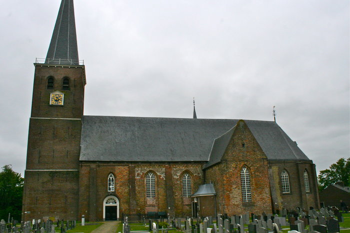
| Description | : | Graveyard surrounding the church in Hallum Hallum, a village in the commune of Ferwerderadeel, is 16 kilometres north of Leeuwarden on the road to Holwerd. The church and churchyard are in the village centre. In the south-eastern corner are the graves of three World War Two airmen, two from the United Kingdom and one from Canada. One of the former is unidentified and buried as an unknown. |
frequently asked questions (FAQ):
-
Where is Hallum Protestant Churchyard?
Hallum Protestant Churchyard is located at Hallum, Ferwerderadiel Municipality ,Friesland ,Netherlands.
-
Hallum Protestant Churchyard cemetery's updated grave count on graveviews.com?
0 memorials
-
Where are the coordinates of the Hallum Protestant Churchyard?
Latitude: 53.3070540
Longitude: 5.7853420

Nearby Cemetories:
1. Westernijtsjerk Kerkhof
Westernijtsjerk, Ferwerderadiel Municipality, Netherlands
Coordinate: 53.3279795, 5.8003224
2. Marrum Churchyard
Marrum, Ferwerderadiel Municipality, Netherlands
Coordinate: 53.3341522, 5.8117681
3. Kerkhof Petruskerk
Wanswerd, Ferwerderadiel Municipality, Netherlands
Coordinate: 53.3009375, 5.8496879
4. Ferwert Kerkhof
Ferwert, Ferwerderadiel Municipality, Netherlands
Coordinate: 53.3388900, 5.8237700
5. Stiens Protestant Churchyard
Stiens, Leeuwarderadeel Municipality, Netherlands
Coordinate: 53.2624810, 5.7572899
6. Kerkhof Nederlands Hervormde kerk Hegebeintum
Hegebeintum, Ferwerderadiel Municipality, Netherlands
Coordinate: 53.3368479, 5.8498713
7. Kerkhof Johanneskerk
Britsum, Leeuwarderadeel Municipality, Netherlands
Coordinate: 53.2542998, 5.7855996
8. Atelierkerk
Ginnum, Ferwerderadiel Municipality, Netherlands
Coordinate: 53.3231763, 5.8745312
9. Algemene Begraafplaats
Vrouwenparochie, Het Bildt Municipality, Netherlands
Coordinate: 53.2849877, 5.6946783
10. Sint-Vituskerk
Wyns, Tytsjerksteradiel Municipality, Netherlands
Coordinate: 53.2516880, 5.8322860
11. Blija Protestant Churchyard
Blija, Ferwerderadiel Municipality, Netherlands
Coordinate: 53.3511734, 5.8606162
12. Kerkhof Cornjum
Cornjum, Leeuwarderadeel Municipality, Netherlands
Coordinate: 53.2431266, 5.7825235
13. Tsjerkhôf Jannum
Jannum, Ferwerderadiel Municipality, Netherlands
Coordinate: 53.3126308, 5.9027619
14. Begraafplaats Aldtsjerk
Aldtsjerk, Tytsjerksteradiel Municipality, Netherlands
Coordinate: 53.2648500, 5.8887300
15. Petruskerkhof
Lichtaard, Ferwerderadiel Municipality, Netherlands
Coordinate: 53.3263379, 5.9135862
16. Lekkum Churchyard
Lekkum, Leeuwarden Municipality, Netherlands
Coordinate: 53.2263300, 5.8194900
17. Marijetsjerke Begraafplaats
Oenkerk, Tytsjerksteradiel Municipality, Netherlands
Coordinate: 53.2537643, 5.8927362
18. Giekerk Martinuskerk
Giekerk, Tytsjerksteradiel Municipality, Netherlands
Coordinate: 53.2411660, 5.8785276
19. Holwerd Protestant Churchyard
Holwerd, Dongeradeel Municipality, Netherlands
Coordinate: 53.3710500, 5.8972200
20. Leeuwarden Noorderbegraafplaats
Leeuwarden, Leeuwarden Municipality, Netherlands
Coordinate: 53.2135900, 5.7733900
21. Kloosterkapel begraafplaats
Sibrandahûs, Dantumadeel Municipality, Netherlands
Coordinate: 53.3111878, 5.9425346
22. Kerkhof Alexanderkerk Rinsumageest
Rinsumageest, Dantumadeel Municipality, Netherlands
Coordinate: 53.2959488, 5.9429579
23. Raard Protestant Churchyard
Raard, Dongeradeel Municipality, Netherlands
Coordinate: 53.3254600, 5.9444900
24. Joodse begraafplaats
Leeuwarden, Leeuwarden Municipality, Netherlands
Coordinate: 53.2089720, 5.7912400