
| Memorials | : | 0 |
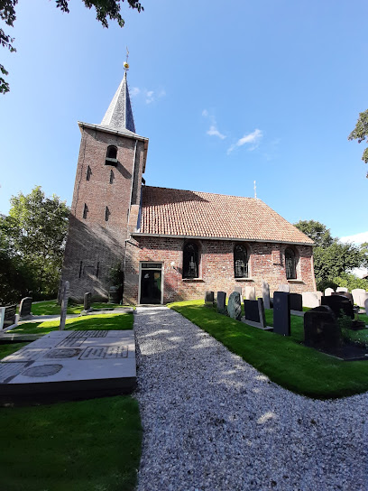
| Location | : | Raard, Dongeradeel Municipality, Netherlands |
| Coordinate | : | 53.3254600, 5.9444900 |
| Description | : | Raard is a village 2 kilometres south-west of the Dokkum-Holwerd road, 4 kilometres from Dokkum and 30 kilometres north-north-east of Leeuwarden. The churchyard surrounds the church, in the centre of the village. |
frequently asked questions (FAQ):
-
Where is Raard Protestant Churchyard?
Raard Protestant Churchyard is located at Raard, Dongeradeel Municipality ,Friesland ,Netherlands.
-
Raard Protestant Churchyard cemetery's updated grave count on graveviews.com?
0 memorials
-
Where are the coordinates of the Raard Protestant Churchyard?
Latitude: 53.3254600
Longitude: 5.9444900
Nearby Cemetories:
1. Kloosterkapel begraafplaats
Sibrandahûs, Dantumadeel Municipality, Netherlands
Coordinate: 53.3111878, 5.9425346
2. Petruskerkhof
Lichtaard, Ferwerderadiel Municipality, Netherlands
Coordinate: 53.3263379, 5.9135862
3. Tsjerkhôf Jannum
Jannum, Ferwerderadiel Municipality, Netherlands
Coordinate: 53.3126308, 5.9027619
4. Kerkhof Alexanderkerk Rinsumageest
Rinsumageest, Dantumadeel Municipality, Netherlands
Coordinate: 53.2959488, 5.9429579
5. Akkerwoude Protestant Churchyard
Akkerwoude, Dantumadeel Municipality, Netherlands
Coordinate: 53.2909300, 5.9779800
6. Atelierkerk
Ginnum, Ferwerderadiel Municipality, Netherlands
Coordinate: 53.3231763, 5.8745312
7. Damwoude General Cemetery
Damwâld, Dantumadeel Municipality, Netherlands
Coordinate: 53.2857700, 5.9996900
8. Holwerd Protestant Churchyard
Holwerd, Dongeradeel Municipality, Netherlands
Coordinate: 53.3710500, 5.8972200
9. Blija Protestant Churchyard
Blija, Ferwerderadiel Municipality, Netherlands
Coordinate: 53.3511734, 5.8606162
10. Rêsthôf Broeksterwâld
Broeksterwoude, Dantumadeel Municipality, Netherlands
Coordinate: 53.2758766, 5.9907295
11. Kerkhof Nederlands Hervormde kerk Hegebeintum
Hegebeintum, Ferwerderadiel Municipality, Netherlands
Coordinate: 53.3368479, 5.8498713
12. Sint-Vituskerk Churchyard
Wetzens, Dongeradeel Municipality, Netherlands
Coordinate: 53.3467450, 6.0345649
13. Kerkhof Petruskerk
Wanswerd, Ferwerderadiel Municipality, Netherlands
Coordinate: 53.3009375, 5.8496879
14. Rêsthôf Driezum
Driezum, Dantumadeel Municipality, Netherlands
Coordinate: 53.2948039, 6.0418101
15. Driesum Protestant Churchyard
Driezum, Dantumadeel Municipality, Netherlands
Coordinate: 53.2977400, 6.0460900
16. Begraafplaats Aldtsjerk
Aldtsjerk, Tytsjerksteradiel Municipality, Netherlands
Coordinate: 53.2648500, 5.8887300
17. It Readtsjerkje hôf
Readtsjerk, Dantumadeel Municipality, Netherlands
Coordinate: 53.2562756, 5.9332706
18. Ferwert Kerkhof
Ferwert, Ferwerderadiel Municipality, Netherlands
Coordinate: 53.3388900, 5.8237700
19. Kleastertsjerke Cemetery
Niawier, Dongeradeel Municipality, Netherlands
Coordinate: 53.3637650, 6.0499337
20. Marijetsjerke Begraafplaats
Oenkerk, Tytsjerksteradiel Municipality, Netherlands
Coordinate: 53.2537643, 5.8927362
21. Marrum Churchyard
Marrum, Ferwerderadiel Municipality, Netherlands
Coordinate: 53.3341522, 5.8117681
22. St. Ceciliatsjerke
Oosternijkerk, Dongeradeel Municipality, Netherlands
Coordinate: 53.3788210, 6.0531531
23. Westernijtsjerk Kerkhof
Westernijtsjerk, Ferwerderadiel Municipality, Netherlands
Coordinate: 53.3279795, 5.8003224
24. Kerkhof Nederlands Hervormde kerk De Westereen
Zwaagwesteinde, Dantumadeel Municipality, Netherlands
Coordinate: 53.2583297, 6.0348107