
| Memorials | : | 0 |
| Location | : | Wyns, Tytsjerksteradiel Municipality, Netherlands |
| Website | : | www.begraafplaats-wyns.nl/ |
| Coordinate | : | 53.2516880, 5.8322860 |
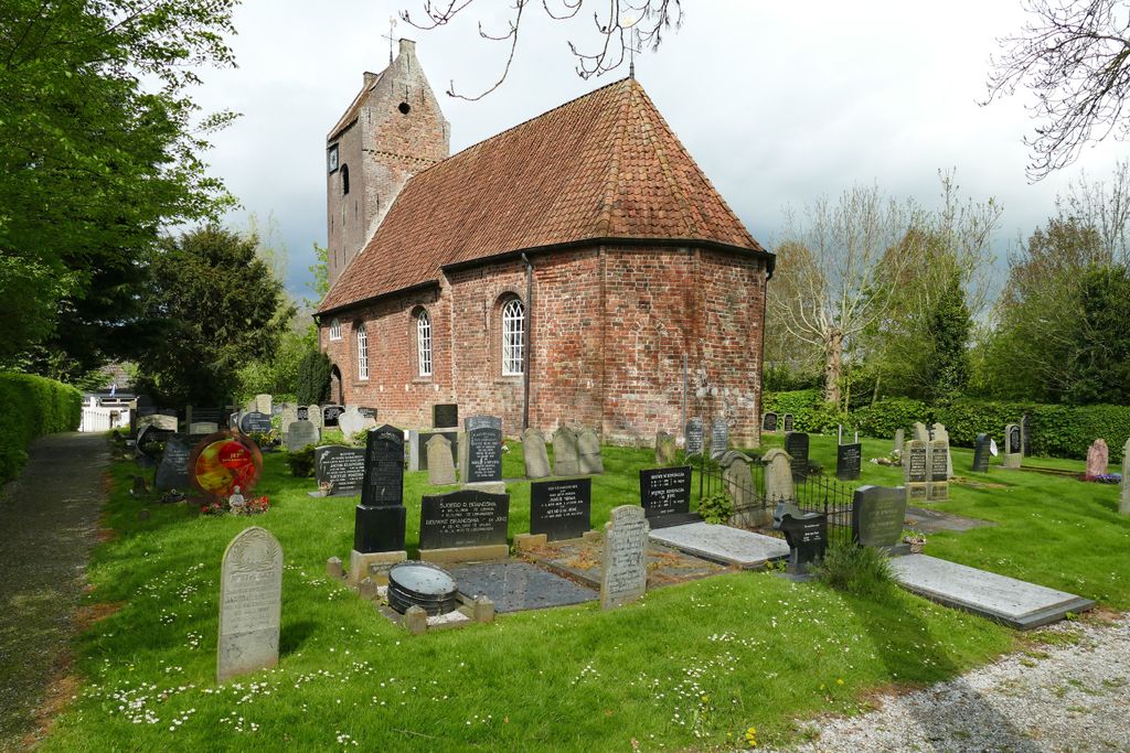
| Description | : | Laatromaanse kerk, gebouwd rond het jaar 1200 met een inwendig halfrond maar uitwendig driezijdig gesloten koor en een iets jongere toren. In de kerk bevindt zich een 17e-eeuwse preekstoel met doophek. De toren is in 1862 gedeeltelijk ommetseld met een klein formaat baksteen. In de toren hangen twee klokken, een van 300 en een van 177 kilogram. De begraafplaats van Wyns ligt rondom de oude kerk op de terp midden in het dorp. De kerk vormt samen met de begraafplaats het hart van het dorpje Wyns, dat gelegen is aan het oude riviertje de Dokkummer Ee. Wyns is het enige terpdorp... Read More |
frequently asked questions (FAQ):
-
Where is Sint-Vituskerk?
Sint-Vituskerk is located at Wyns 31 Wyns, Tytsjerksteradiel Municipality ,Friesland , 9091 BENetherlands.
-
Sint-Vituskerk cemetery's updated grave count on graveviews.com?
0 memorials
-
Where are the coordinates of the Sint-Vituskerk?
Latitude: 53.2516880
Longitude: 5.8322860

Nearby Cemetories:
1. Lekkum Churchyard
Lekkum, Leeuwarden Municipality, Netherlands
Coordinate: 53.2263300, 5.8194900
2. Kerkhof Johanneskerk
Britsum, Leeuwarderadeel Municipality, Netherlands
Coordinate: 53.2542998, 5.7855996
3. Giekerk Martinuskerk
Giekerk, Tytsjerksteradiel Municipality, Netherlands
Coordinate: 53.2411660, 5.8785276
4. Kerkhof Cornjum
Cornjum, Leeuwarderadeel Municipality, Netherlands
Coordinate: 53.2431266, 5.7825235
5. Marijetsjerke Begraafplaats
Oenkerk, Tytsjerksteradiel Municipality, Netherlands
Coordinate: 53.2537643, 5.8927362
6. Begraafplaats Aldtsjerk
Aldtsjerk, Tytsjerksteradiel Municipality, Netherlands
Coordinate: 53.2648500, 5.8887300
7. Stiens Protestant Churchyard
Stiens, Leeuwarderadeel Municipality, Netherlands
Coordinate: 53.2624810, 5.7572899
8. Joodse begraafplaats
Leeuwarden, Leeuwarden Municipality, Netherlands
Coordinate: 53.2089720, 5.7912400
9. Kerkhof Petruskerk
Wanswerd, Ferwerderadiel Municipality, Netherlands
Coordinate: 53.3009375, 5.8496879
10. Leeuwarden Noorderbegraafplaats
Leeuwarden, Leeuwarden Municipality, Netherlands
Coordinate: 53.2135900, 5.7733900
11. Algemene Rooms-Katholieke Begraafplaats Vitushof
Leeuwarden, Leeuwarden Municipality, Netherlands
Coordinate: 53.2061700, 5.7694100
12. Rijperkerk Nederlands Hervormd Kerkhof
Rijperkerk, Tytsjerksteradiel Municipality, Netherlands
Coordinate: 53.2221200, 5.9183300
13. It Readtsjerkje hôf
Readtsjerk, Dantumadeel Municipality, Netherlands
Coordinate: 53.2562756, 5.9332706
14. Hallum Protestant Churchyard
Hallum, Ferwerderadiel Municipality, Netherlands
Coordinate: 53.3070540, 5.7853420
15. Begraafplaats Sint-Vituskerk
Tytsjerk, Tytsjerksteradiel Municipality, Netherlands
Coordinate: 53.2062242, 5.9142663
16. Tsjerkhôf Jannum
Jannum, Ferwerderadiel Municipality, Netherlands
Coordinate: 53.3126308, 5.9027619
17. Sint-Pontianustsjerke
Marsum, Menaldumadeel Municipality, Netherlands
Coordinate: 53.2108700, 5.7280502
18. Agnestsjerke
Goutum, Leeuwarden Municipality, Netherlands
Coordinate: 53.1786867, 5.8068433
19. Hoftsjerke begraafplaats
Hurdegaryp, Tytsjerksteradiel Municipality, Netherlands
Coordinate: 53.2175817, 5.9445193
20. Atelierkerk
Ginnum, Ferwerderadiel Municipality, Netherlands
Coordinate: 53.3231763, 5.8745312
21. Westernijtsjerk Kerkhof
Westernijtsjerk, Ferwerderadiel Municipality, Netherlands
Coordinate: 53.3279795, 5.8003224
22. Kerkhof Alexanderkerk Rinsumageest
Rinsumageest, Dantumadeel Municipality, Netherlands
Coordinate: 53.2959488, 5.9429579
23. Marrum Churchyard
Marrum, Ferwerderadiel Municipality, Netherlands
Coordinate: 53.3341522, 5.8117681
24. Kerkhof Nederlands Hervormde kerk Hegebeintum
Hegebeintum, Ferwerderadiel Municipality, Netherlands
Coordinate: 53.3368479, 5.8498713