
| Memorials | : | 0 |
| Location | : | Hoedekenskerke, Borsele Municipality, Netherlands |
| Coordinate | : | 51.4224100, 3.9129400 |
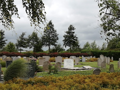
| Description | : | This cemetery is situated just outside the village. The cemetery is in use since January 1, 1873. Before that date the dead were burried in the churchyard, surrounding the (remains of a large) church. By law it was forbidden to have a graveyard near the houses. |
frequently asked questions (FAQ):
-
Where is Hoedekenskerke Waardweg Cemetery?
Hoedekenskerke Waardweg Cemetery is located at Waardweg Hoedekenskerke, Borsele Municipality ,Zeeland ,Netherlands.
-
Hoedekenskerke Waardweg Cemetery cemetery's updated grave count on graveviews.com?
0 memorials
-
Where are the coordinates of the Hoedekenskerke Waardweg Cemetery?
Latitude: 51.4224100
Longitude: 3.9129400
Nearby Cemetories:
1. Hoedekenskerke Old Churchyard
Hoedekenskerke, Borsele Municipality, Netherlands
Coordinate: 51.4235320, 3.9121413
2. Baarland Steenweg Cemetery
Baarland, Borsele Municipality, Netherlands
Coordinate: 51.4072879, 3.8944024
3. Lenshoekdijk Old
's-Gravenpolder, Borsele Municipality, Netherlands
Coordinate: 51.4554900, 3.9012800
4. 's-Gravenpolder Algemene Begraafplaats
's-Gravenpolder, Borsele Municipality, Netherlands
Coordinate: 51.4556100, 3.9003500
5. Oudelande Algemene Begraafplaats
Oudelande, Borsele Municipality, Netherlands
Coordinate: 51.4095600, 3.8564700
6. Willibrorduskerk v.m.
Ossenisse, Hulst Municipality, Netherlands
Coordinate: 51.3888248, 3.9803445
7. Algemene Begraafplaats
Nisse, Borsele Municipality, Netherlands
Coordinate: 51.4584900, 3.8467600
8. Ovezande Bloemenstraat Cemetery
Ovezande, Borsele Municipality, Netherlands
Coordinate: 51.4274400, 3.8208500
9. Crematorium en uitvaartcentrum Het Zeeuwse Land
Goes Municipality, Netherlands
Coordinate: 51.4810570, 3.8994665
10. Biezelinge Algemene Begraafplaats
Biezelinge, Kapelle Municipality, Netherlands
Coordinate: 51.4777300, 3.9575600
11. Ellewoutsdijk Begraafplaats
Ellewoutsdijk, Borsele Municipality, Netherlands
Coordinate: 51.3922900, 3.8175300
12. Driewegen Protestant Cemetery
Driewegen, Borsele Municipality, Netherlands
Coordinate: 51.4176900, 3.8052200
13. Schore Algemene Begraafplaats
Schore, Kapelle Municipality, Netherlands
Coordinate: 51.4658500, 3.9969800
14. Kapelle French Military Cemetery
Kapelle, Kapelle Municipality, Netherlands
Coordinate: 51.4877370, 3.9482423
15. Kloetinge General Cemetery
Kloetinge, Goes Municipality, Netherlands
Coordinate: 51.4971500, 3.9232100
16. Kruiningen General Cemetery
Kruiningen, Reimerswaal Municipality, Netherlands
Coordinate: 51.4488400, 4.0277900
17. Heinkenszand Kerklaan Cemetery
Heinkenszand, Borsele Municipality, Netherlands
Coordinate: 51.4717900, 3.8139200
18. Kloosterzande General Cemetery
Kloosterzande, Hulst Municipality, Netherlands
Coordinate: 51.3644390, 4.0211730
19. 's-Heer-Hendrikskinderen Algemene Begraafplaats
's-Heer Hendrikskinderen, Goes Municipality, Netherlands
Coordinate: 51.5012100, 3.8463800
20. Goes Algemene Begraafplaats
Goes, Goes Municipality, Netherlands
Coordinate: 51.5120600, 3.8866100
21. H. Catharina Church Cemetery
Hengstdijk, Hulst Municipality, Netherlands
Coordinate: 51.3467612, 3.9979042
22. R.K. Begraafplaats
's-Heerenhoek, Borsele Municipality, Netherlands
Coordinate: 51.4542131, 3.7715854
23. Begraafplaats Memento Mori
Waarde, Reimerswaal Municipality, Netherlands
Coordinate: 51.4202400, 4.0657000
24. 's-Heerenhoek Old Cemetery
's-Heerenhoek, Borsele Municipality, Netherlands
Coordinate: 51.4634500, 3.7642900