
| Memorials | : | 0 |
| Location | : | Hoggeston, Aylesbury Vale District, England |
| Coordinate | : | 51.9179220, -0.8260200 |
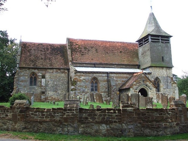
| Description | : | The parish church of Hoggeston is dedicated to the Holy Cross. The church has a 16th century weatherboarded bell turret (containing 3 Change ringing Bells and a Sanctus bell) over the north aisle. The origins of the church are 13th century. There are 14th century additions, and some perpendicular windows of the same era. The stained glass east window was designed by Sir Ninian Comper in 1949. The wrought iron gate, made in the 1970s, into the church yard depicts a stag, the crest of the Micklem family, who resided at Maines Hill, a house just outside the confines of... Read More |
frequently asked questions (FAQ):
-
Where is Holy Cross Churchyard?
Holy Cross Churchyard is located at Hoggeston, Aylesbury Vale District ,Buckinghamshire ,England.
-
Holy Cross Churchyard cemetery's updated grave count on graveviews.com?
0 memorials
-
Where are the coordinates of the Holy Cross Churchyard?
Latitude: 51.9179220
Longitude: -0.8260200
Nearby Cemetories:
1. St Martin's churchyard
Dunton, Aylesbury Vale District, England
Coordinate: 51.9117610, -0.8038370
2. Swanbourne Cemetery
Swanbourne, Aylesbury Vale District, England
Coordinate: 51.9353700, -0.8349600
3. St. Swithun's Churchyard
Swanbourne, Aylesbury Vale District, England
Coordinate: 51.9382920, -0.8362480
4. Mursley Cemetery
Mursley, Aylesbury Vale District, England
Coordinate: 51.9483550, -0.8110360
5. St Mary the Virgin Churchyard
Mursley, Aylesbury Vale District, England
Coordinate: 51.9494170, -0.8125050
6. St. Mary's Churchyard
North Marston, Aylesbury Vale District, England
Coordinate: 51.8971600, -0.8720400
7. St John the Baptist Churchyard
Granborough, Aylesbury Vale District, England
Coordinate: 51.9180150, -0.8850860
8. St. Nicholas' Churchyard
Cublington, Aylesbury Vale District, England
Coordinate: 51.8918828, -0.7825741
9. St. John the Evangelist Churchyard
Whitchurch, Aylesbury Vale District, England
Coordinate: 51.8806720, -0.8351220
10. All Saints Churchyard
Oving, Aylesbury Vale District, England
Coordinate: 51.8859230, -0.8644540
11. Primitive Methodist Church Churchyard (Defunct)
North Marston, Aylesbury Vale District, England
Coordinate: 51.8987110, -0.8828110
12. St. Michael & All Angels Churchyard
Stewkley, Aylesbury Vale District, England
Coordinate: 51.9269300, -0.7625700
13. Holy Trinity Churchyard
Drayton Parslow, Aylesbury Vale District, England
Coordinate: 51.9508846, -0.7802638
14. St. Giles Churchyard
Pitchcott, Aylesbury Vale District, England
Coordinate: 51.8768733, -0.8750126
15. St Mary the Virgin with Weedon Churchyard
Hardwick, Aylesbury Vale District, England
Coordinate: 51.8636070, -0.8301330
16. St. Nicholas Churchyard
Little Horwood, Aylesbury Vale District, England
Coordinate: 51.9703630, -0.8508680
17. St. James the Great Churchyard
Aston Abbotts, Aylesbury Vale District, England
Coordinate: 51.8742390, -0.7706790
18. St. Mary the Virgin Churchyard
East Claydon, Aylesbury Vale District, England
Coordinate: 51.9234470, -0.9254750
19. Weedon Methodist Chapelyard
Weedon, Aylesbury Vale District, England
Coordinate: 51.8554190, -0.8184970
20. St. James Churchyard
Great Horwood, Aylesbury Vale District, England
Coordinate: 51.9740230, -0.8792870
21. St. Mary's Churchyard
Addington, Aylesbury Vale District, England
Coordinate: 51.9497100, -0.9206790
22. St. John the Baptist Churchyard
Hogshaw, Aylesbury Vale District, England
Coordinate: 51.8966960, -0.9297480
23. St. Faith Churchyard
Newton Longville, Aylesbury Vale District, England
Coordinate: 51.9748000, -0.7667600
24. All Saints Churchyard
Wing, Aylesbury Vale District, England
Coordinate: 51.8945984, -0.7227797