
| Memorials | : | 0 |
| Location | : | Ilkeston, Erewash Borough, England |
| Coordinate | : | 52.9645800, -1.3077120 |
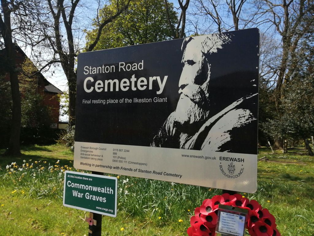
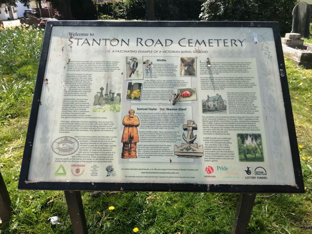
| Description | : | Stanton Road Cemetery came up on a search in Billion Graves. I think it is probably closed for interments long ago. http://churchdb.gukutils.org.uk/DBY1007.php There is a history of Stanton Road Cemetery on the Ilkeston and District Local History Society website. Briefly, the Ilkeston General Cemetery Company was established in 1863, and the Cemetery opened in 1866. Ilkeston's Park Road Cemetery was opened in 1892. Derbyshire Record Office hold registers of burials in the Cemetery for the period 1864-1997. |
frequently asked questions (FAQ):
-
Where is Ilkeston Stanton Road?
Ilkeston Stanton Road is located at Stanton Road, Ilkeston, Derbyshire Ilkeston, Erewash Borough ,Derbyshire , DE7 5FWEngland.
-
Ilkeston Stanton Road cemetery's updated grave count on graveviews.com?
0 memorials
-
Where are the coordinates of the Ilkeston Stanton Road?
Latitude: 52.9645800
Longitude: -1.3077120
Nearby Cemetories:
1. All Saints
Kirk Hallam, Erewash Borough, England
Coordinate: 52.9602950, -1.3188150
2. Park Cemetery
Ilkeston, Erewash Borough, England
Coordinate: 52.9714000, -1.3006350
3. St. Helen's Churchyard
Trowell, Broxtowe Borough, England
Coordinate: 52.9528120, -1.2815590
4. St. Wilfrid Churchyard
West Hallam, Erewash Borough, England
Coordinate: 52.9656640, -1.3579720
5. Holy Trinity Churchyard
Mapperley, Amber Valley Borough, England
Coordinate: 52.9818800, -1.3536800
6. Bramcote Crematorium
Beeston, Broxtowe Borough, England
Coordinate: 52.9456300, -1.2555100
7. All Saints Church
Strelley, Broxtowe Borough, England
Coordinate: 52.9737900, -1.2470340
8. St. Helen's Churchyard
Stapleford, Broxtowe Borough, England
Coordinate: 52.9316670, -1.2744440
9. Stapleford Cemetery
Stapleford, Broxtowe Borough, England
Coordinate: 52.9299770, -1.2699190
10. St. Andrew's Churchyard
Stanley, Erewash Borough, England
Coordinate: 52.9594760, -1.3772680
11. Eastwood Cemetery
Eastwood, Broxtowe Borough, England
Coordinate: 53.0115814, -1.3073300
12. St. Michael and All Angels Churchyard
Bramcote, Broxtowe Borough, England
Coordinate: 52.9352531, -1.2463690
13. All Saints Churchyard
Stanley Common, Erewash Borough, England
Coordinate: 52.9770772, -1.3834721
14. All Saints Risley Churchyard
Risley, Erewash Borough, England
Coordinate: 52.9164000, -1.3158000
15. Marlpool Municipal Cemetery
Heanor, Amber Valley Borough, England
Coordinate: 53.0082110, -1.3490550
16. Wollaton Cemetery
Wollaton, Nottingham Unitary Authority, England
Coordinate: 52.9503000, -1.2260800
17. St. Mary's Churchyard
Eastwood, Broxtowe Borough, England
Coordinate: 53.0166227, -1.3084371
18. St. Leonard's Churchyard
Wollaton, Nottingham Unitary Authority, England
Coordinate: 52.9529790, -1.2200830
19. Beeston Cemetery
Beeston, Broxtowe Borough, England
Coordinate: 52.9354540, -1.2275310
20. Ockbrook Moravian Burial Ground
Ockbrook, Erewash Borough, England
Coordinate: 52.9215600, -1.3755740
21. St. Mary's Churchyard
Greasley, Broxtowe Borough, England
Coordinate: 53.0201100, -1.2720500
22. St. John the Baptist Churchyard
Smalley, Amber Valley Borough, England
Coordinate: 52.9930300, -1.3961360
23. All Saints Churchyard
Ockbrook, Erewash Borough, England
Coordinate: 52.9170770, -1.3713030
24. Smalley Baptist Churchyard
Smalley, Amber Valley Borough, England
Coordinate: 52.9968520, -1.3947580