
| Memorials | : | 1 |
| Location | : | Kelsey, El Dorado County, USA |
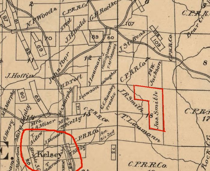
| Description | : | The property of Joseph Smith, an African-American pioneer of El Dorado County, is the location of his grave. Smith obtained a Federal Land Patent for this land which was described in his Probate file documents to be the N.E. 1/4 of N.W. 1/4, the W. 1/2 of N.E. 1/4 and the N.W. 1/4 of S. E. 1/4, Sec. 18, Tp. (township) 11, North, R. (range) 11 East, M.D.B. M. This matches exactly the patent issued to Smith in the year 1894. A view of the location of Smith's land in relation to the town of Kelsey and nearby... Read More |
frequently asked questions (FAQ):
-
Where is Joseph Smith Ranch?
Joseph Smith Ranch is located at Kelsey, El Dorado County, USA.
-
Joseph Smith Ranch cemetery's updated grave count on graveviews.com?
1 memorials
Nearby Cemetories:
1. Andreason Cemetery
Apex, El Dorado County, USA
Coordinate: 38.6941590, -120.8187750
2. Fairplay Cemetery
Fair Play, El Dorado County, USA
Coordinate: 38.6940960, -120.8186620
3. Heusner Ranch Family Cemetery
Buckeye, El Dorado County, USA
Coordinate: 38.6963882, -120.8151932
4. Greenwood Pioneer Cemetery
Greenwood, El Dorado County, USA
5. Hoboken House
Greenwood, El Dorado County, USA
Coordinate: 38.8438800, -121.0148900
6. Spanish Dry Diggings Cemetery
Greenwood, El Dorado County, USA
Coordinate: 38.8301010, -121.0093307
7. Al Tahoe Cemetery
South Lake Tahoe, El Dorado County, USA
8. Happy Homestead Cemetery
South Lake Tahoe, El Dorado County, USA
9. Johnson-Springmeyer Cemetery
South Lake Tahoe, El Dorado County, USA
Coordinate: 38.8822220, -120.2055560
10. Rust Family Gravesite
Cameron Park, El Dorado County, USA
Coordinate: 38.7547140, -120.7098510
11. Saint Michaels Catholic Cemetery
Cameron Park, El Dorado County, USA
Coordinate: 38.7450981, -120.6564407
12. Skinner Ranch Cemetery
Cameron Park, El Dorado County, USA
Coordinate: 38.5830383, -120.9679184
13. Carpenter Family Residence Burial Plot
Diamond Springs, El Dorado County, USA
Coordinate: 38.6941590, -120.8187750
14. Diamond Springs Cemetery
Diamond Springs, El Dorado County, USA
Coordinate: 38.6940960, -120.8186620
15. Odd Fellows Cemetery
Diamond Springs, El Dorado County, USA
Coordinate: 38.6963882, -120.8151932
16. Ringgold Cemetery
Diamond Springs, El Dorado County, USA
17. Bayley Family Cemetery
Pilot Hill, El Dorado County, USA
Coordinate: 38.8438800, -121.0148900
18. Pilot Hill Cemetery
Pilot Hill, El Dorado County, USA
Coordinate: 38.8301010, -121.0093307
19. Pilot Springs House - Avery Grave
Pilot Hill, El Dorado County, USA
20. Wild Goose Flat Cemetery
Pilot Hill, El Dorado County, USA
21. William W Tyler’s Grave
El Dorado County, USA
Coordinate: 38.8822220, -120.2055560
22. Blairs-Winkelman Cemetery
Camino, El Dorado County, USA
Coordinate: 38.7547140, -120.7098510
23. Camino Cemetery
Camino, El Dorado County, USA
Coordinate: 38.7450981, -120.6564407
24. Bryant Cemetery
Latrobe, El Dorado County, USA
Coordinate: 38.5830383, -120.9679184