
| Memorials | : | 1 |
| Location | : | Conway, Franklin County, USA |
| Coordinate | : | 42.4836630, -72.7195800 |
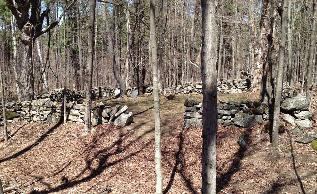
| Description | : | The cemetery is off of Old Cricket Hill Road on the north side of a nameless abandoned road that is lined on both sides with stone walls, it is directly across the old road from a large, deep cellar hole that the 1871 F.W. Beers Atlas of Franklin County labeled as belonging to "Z. Bates". At one time it was the home of the town's poor farm. The cemetery itself is bounded on all four sides by stone walls, and its very small - maybe 25' x 35'. The Massachusetts Historical Commission does not refer to this cemetery... Read More |
frequently asked questions (FAQ):
-
Where is Maynard Cemetery?
Maynard Cemetery is located at Town Farm Road Conway, Franklin County ,Massachusetts , 01341USA.
-
Maynard Cemetery cemetery's updated grave count on graveviews.com?
1 memorials
-
Where are the coordinates of the Maynard Cemetery?
Latitude: 42.4836630
Longitude: -72.7195800
Nearby Cemetories:
1. Cricket Hill Cemetery
Conway, Franklin County, USA
Coordinate: 42.4783300, -72.7009500
2. South Centre Cemetery
Conway, Franklin County, USA
Coordinate: 42.5015940, -72.6973490
3. Southwest Cemetery
Conway, Franklin County, USA
Coordinate: 42.4660280, -72.7458610
4. Howland Cemetery
Conway, Franklin County, USA
Coordinate: 42.5127983, -72.6967010
5. Boyden Cemetery
Conway, Franklin County, USA
Coordinate: 42.4832993, -72.6667023
6. South Part Cemetery
Conway, Franklin County, USA
Coordinate: 42.4625015, -72.6707993
7. Pine Grove Cemetery
Conway, Franklin County, USA
Coordinate: 42.5222015, -72.6908035
8. Briar Hill Cemetery
Ashfield, Franklin County, USA
Coordinate: 42.4742600, -72.7798300
9. South Ashfield Cemetery
Ashfield, Franklin County, USA
Coordinate: 42.5077209, -72.7730026
10. West Whately Cemetery
Whately, Franklin County, USA
Coordinate: 42.4335251, -72.6772766
11. Beldingville Cemetery
Ashfield, Franklin County, USA
Coordinate: 42.5365562, -72.7638016
12. Mill River Cemetery
Deerfield, Franklin County, USA
Coordinate: 42.5011890, -72.6377770
13. Rogers Cemetery
Williamsburg, Hampshire County, USA
Coordinate: 42.4300800, -72.7661000
14. Saint John's Church
Ashfield, Franklin County, USA
Coordinate: 42.5258600, -72.7894260
15. Plain Cemetery
Ashfield, Franklin County, USA
Coordinate: 42.5292015, -72.7889023
16. Hill Cemetery
Ashfield, Franklin County, USA
Coordinate: 42.5208015, -72.7992020
17. Goshen Center Cemetery
Goshen, Hampshire County, USA
Coordinate: 42.4483280, -72.8049800
18. Center Cemetery
Whately, Franklin County, USA
Coordinate: 42.4431000, -72.6363983
19. Baptist Corner Cemetery
Ashfield, Franklin County, USA
Coordinate: 42.5540771, -72.7639313
20. Brookside Cemetery
Deerfield, Franklin County, USA
Coordinate: 42.4707985, -72.6106033
21. Cosby Family Cemetery
Shelburne, Franklin County, USA
Coordinate: 42.5566400, -72.6702100
22. Saint Stanislaus Cemetery
Deerfield, Franklin County, USA
Coordinate: 42.4707985, -72.6082993
23. Sugarloaf Street Cemetery
South Deerfield, Franklin County, USA
Coordinate: 42.4762800, -72.6071500
24. Holy Ghost Ukrainian Catholic Cemetery
Whately, Franklin County, USA
Coordinate: 42.4639015, -72.6097031