
| Memorials | : | 72 |
| Location | : | Carlisle, Noble County, USA |
| Coordinate | : | 39.7220001, -81.3229980 |
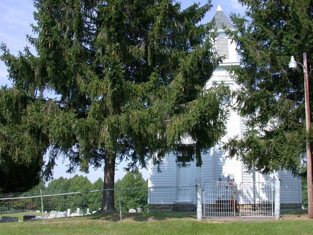
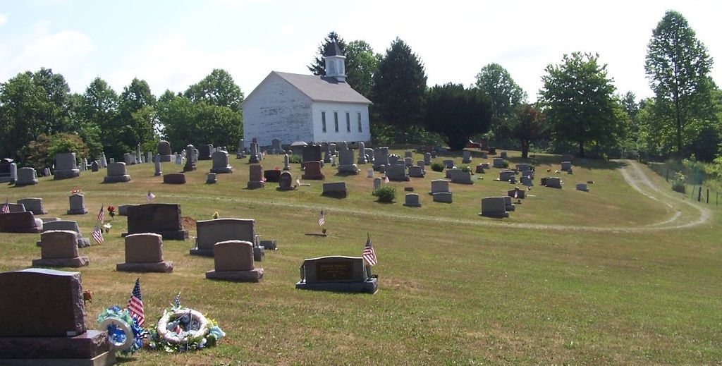
| Description | : | The cemetery if located behind and on either side of the Mount Tabor Church on the west side of Crum Ridge Road (County Road 45) at its intersection with Tabor Ridge Road (County Road 3). The cemetery is 1.5 acres in size. The cemetery is located in Stock Township, Nobel County, Ohio, and is # 9151 (Mount Tabor Cemetery / Tabor Ridge Cemetery) in “Ohio Cemeteries 1803-2003”, compiled by the Ohio Genealogical Society. The U.S. Geological Survey (USGS) Geographic Names Information System (GNIS) feature ID for the cemetery is 1877645 (Mount Tabor Cemetery). |
frequently asked questions (FAQ):
-
Where is Mount Tabor Cemetery?
Mount Tabor Cemetery is located at Crum Ridge Road (County Road 45) Carlisle, Noble County ,Ohio , 43788USA.
-
Mount Tabor Cemetery cemetery's updated grave count on graveviews.com?
67 memorials
-
Where are the coordinates of the Mount Tabor Cemetery?
Latitude: 39.7220001
Longitude: -81.3229980
Nearby Cemetories:
1. Crum Ridge Cemetery
Noble County, USA
Coordinate: 39.6884100, -81.3323400
2. Curtis Ridge Cemetery
Noble County, USA
Coordinate: 39.7546997, -81.3419037
3. Stafford Cemetery
Stafford, Monroe County, USA
Coordinate: 39.7128500, -81.2723400
4. Carlisle Methodist Cemetery
Carlisle, Noble County, USA
Coordinate: 39.7459490, -81.3660950
5. Saint Michaels Catholic Church Cemetery
Carlisle, Noble County, USA
Coordinate: 39.7450870, -81.3673140
6. Sutherland Methodist Cemetery
Stafford, Monroe County, USA
Coordinate: 39.7281281, -81.2692804
7. Vance Cemetery
Harriettsville, Noble County, USA
Coordinate: 39.6855760, -81.2877440
8. Crow Cemetery
Carlisle, Noble County, USA
Coordinate: 39.7651500, -81.3469770
9. Rado Cemetery
Noble County, USA
Coordinate: 39.7019005, -81.3818970
10. Swazey Methodist Cemetery
Monroe County, USA
Coordinate: 39.7661800, -81.2887300
11. Stewart Cemetery
Noble County, USA
Coordinate: 39.6699982, -81.3244019
12. Road Fork Cemetery
Noble County, USA
Coordinate: 39.6683040, -81.3139180
13. Mount Zion Methodist Cemetery
Lewisville, Monroe County, USA
Coordinate: 39.7238390, -81.2483750
14. Old Saint Michaels Cemetery
Noble County, USA
Coordinate: 39.7549800, -81.3853300
15. Archer Cemetery
Stock Township, Noble County, USA
Coordinate: 39.7548250, -81.3859140
16. Bracken Ridge Church Cemetery
Summit Township, Monroe County, USA
Coordinate: 39.7747960, -81.2629620
17. Hines Chapel Church of Christ Cemetery
Monroe County, USA
Coordinate: 39.6922900, -81.2398300
18. Saint Marys Cemetery
Fulda, Noble County, USA
Coordinate: 39.7232780, -81.4151840
19. East Union Cemetery
East Union, Noble County, USA
Coordinate: 39.7689600, -81.3973400
20. Parks Cemetery
Marr, Monroe County, USA
Coordinate: 39.6611500, -81.2681900
21. Hesson Family Cemetery
Noble County, USA
Coordinate: 39.6847000, -81.4068985
22. Summerfield Methodist Church Cemetery
Summerfield, Noble County, USA
Coordinate: 39.7967339, -81.3358231
23. Creighton Ridge Church of Christ Cemetery
Marr, Monroe County, USA
Coordinate: 39.6629320, -81.2612340
24. Wise Cemetery
Lewisville, Monroe County, USA
Coordinate: 39.7754620, -81.2504200