
| Memorials | : | 8 |
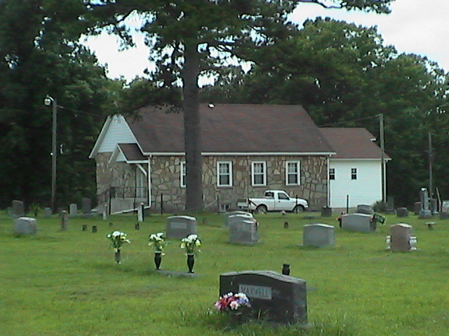
| Location | : | Dry Creek Township, Howell County, USA |
| Coordinate | : | 36.8299200, -91.9486000 |
| Description | : | Take 63 north (from west plains) to Olden, Missouri, turn left on road 474, go one mile, take first road to left road 474, go 1/2 mile, turn right on road 470 to road 487. Cemetery is on the right. Section 21, Twp 25, R9. |
frequently asked questions (FAQ):
-
Where is Mount Zion Cemetery?
Mount Zion Cemetery is located at Dry Creek Township, Howell County ,Missouri ,USA.
-
Mount Zion Cemetery cemetery's updated grave count on graveviews.com?
8 memorials
-
Where are the coordinates of the Mount Zion Cemetery?
Latitude: 36.8299200
Longitude: -91.9486000
Nearby Cemetories:
1. Howell Memorial Park Cemetery
Pomona, Howell County, USA
Coordinate: 36.8460007, -91.9181976
2. Sadie Brown Cemetery
West Plains, Howell County, USA
Coordinate: 36.7967186, -91.8965530
3. Dry Creek Cemetery
Pomona, Howell County, USA
Coordinate: 36.8776800, -91.9886100
4. Lone Pine Cemetery
West Plains, Howell County, USA
Coordinate: 36.7813988, -91.9057999
5. New Liberty Baptist Cemetery
Grimmet, Howell County, USA
Coordinate: 36.7775002, -91.9869003
6. Collins Cemetery
Siloam Springs, Howell County, USA
Coordinate: 36.7858009, -92.0139008
7. Buff Cemetery
West Plains, Howell County, USA
Coordinate: 36.8633003, -92.0261002
8. Oak Grove Cemetery
West Plains, Howell County, USA
Coordinate: 36.8633838, -92.0262578
9. Mackey Cemetery
Pomona, Howell County, USA
Coordinate: 36.8659554, -91.8659134
10. Epps Cemetery
Pomona, Howell County, USA
Coordinate: 36.9057999, -91.9203033
11. Dripping Springs Cemetery
West Plains, Howell County, USA
Coordinate: 36.8175583, -91.8487625
12. Hopes Rest Cemetery
West Plains, Howell County, USA
Coordinate: 36.7452500, -91.9557700
13. Burnham Cemetery
Burnham, Howell County, USA
Coordinate: 36.9207993, -91.9496994
14. Campbell Cemetery
West Plains, Howell County, USA
Coordinate: 36.7563600, -91.8721200
15. Pleasant Hill Cemetery
Pottersville, Howell County, USA
Coordinate: 36.7310982, -91.9606018
16. Galloway Cemetery
West Plains, Howell County, USA
Coordinate: 36.7529106, -91.8682175
17. Antioch Cemetery
Pomona, Howell County, USA
Coordinate: 36.8725200, -91.8307400
18. Pleasant View Cemetery
West Plains, Howell County, USA
Coordinate: 36.7900009, -91.8257980
19. Lost Camp Cemetery
Pomona, Howell County, USA
Coordinate: 36.9105988, -91.8566971
20. Horton Cemetery
Howell County, USA
Coordinate: 36.8678017, -92.0867004
21. Siloam Springs Cemetery
Gentryville, Douglas County, USA
Coordinate: 36.7867012, -92.0875015
22. Siloam Springs Cemetery
Siloam Springs, Howell County, USA
Coordinate: 36.7867100, -92.0876400
23. Union Grove General Baptist Cemetery
West Plains, Howell County, USA
Coordinate: 36.7403380, -92.0601540
24. Blue Mound Cemetery
Pottersville, Howell County, USA
Coordinate: 36.7026100, -91.9695200