
| Memorials | : | 6 |
| Location | : | Grimmet, Howell County, USA |
| Coordinate | : | 36.7775002, -91.9869003 |
frequently asked questions (FAQ):
-
Where is New Liberty Baptist Cemetery?
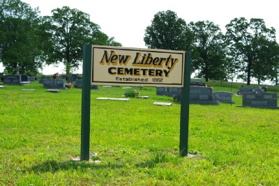
New Liberty Baptist Cemetery is located at Grimmet, Howell County ,Missouri ,USA.
-
New Liberty Baptist Cemetery cemetery's updated grave count on graveviews.com?
5 memorials
-
Where are the coordinates of the New Liberty Baptist Cemetery?
Latitude: 36.7775002
Longitude: -91.9869003
Nearby Cemetories:
1. Collins Cemetery
Siloam Springs, Howell County, USA
Coordinate: 36.7858009, -92.0139008
2. Hopes Rest Cemetery
West Plains, Howell County, USA
Coordinate: 36.7452500, -91.9557700
3. Pleasant Hill Cemetery
Pottersville, Howell County, USA
Coordinate: 36.7310982, -91.9606018
4. Mount Zion Cemetery
Dry Creek Township, Howell County, USA
Coordinate: 36.8299200, -91.9486000
5. Lone Pine Cemetery
West Plains, Howell County, USA
Coordinate: 36.7813988, -91.9057999
6. Union Grove General Baptist Cemetery
West Plains, Howell County, USA
Coordinate: 36.7403380, -92.0601540
7. Sadie Brown Cemetery
West Plains, Howell County, USA
Coordinate: 36.7967186, -91.8965530
8. Blue Mound Cemetery
Pottersville, Howell County, USA
Coordinate: 36.7026100, -91.9695200
9. Siloam Springs Cemetery
Gentryville, Douglas County, USA
Coordinate: 36.7867012, -92.0875015
10. Siloam Springs Cemetery
Siloam Springs, Howell County, USA
Coordinate: 36.7867100, -92.0876400
11. Pottersville Cemetery
Pottersville, Howell County, USA
Coordinate: 36.6972008, -92.0152969
12. Ledbetter Cemetery
Pottersville, Howell County, USA
Coordinate: 36.7256012, -92.0753021
13. Howell Memorial Park Cemetery
Pomona, Howell County, USA
Coordinate: 36.8460007, -91.9181976
14. Buff Cemetery
West Plains, Howell County, USA
Coordinate: 36.8633003, -92.0261002
15. Oak Grove Cemetery
West Plains, Howell County, USA
Coordinate: 36.8633838, -92.0262578
16. Campbell Cemetery
West Plains, Howell County, USA
Coordinate: 36.7563600, -91.8721200
17. Mitts Cemetery
Howell County, USA
Coordinate: 36.7633018, -92.1066971
18. Galloway Cemetery
West Plains, Howell County, USA
Coordinate: 36.7529106, -91.8682175
19. Dry Creek Cemetery
Pomona, Howell County, USA
Coordinate: 36.8776800, -91.9886100
20. Gospel Hill Church of Christ Cemetery
Pottersville, Howell County, USA
Coordinate: 36.6812100, -92.0570100
21. Dripping Springs Cemetery
West Plains, Howell County, USA
Coordinate: 36.8175583, -91.8487625
22. Horton Cemetery
Howell County, USA
Coordinate: 36.8678017, -92.0867004
23. Homeland Cemetery
Homeland, Howell County, USA
Coordinate: 36.6706009, -91.9167023
24. Thornton-Roosevelt Cemetery
Roosevelt, Douglas County, USA
Coordinate: 36.8325005, -92.1216965