
| Memorials | : | 0 |
| Location | : | Selmer, McNairy County, USA |
| Coordinate | : | 35.1730920, -88.5710370 |
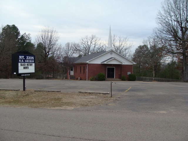
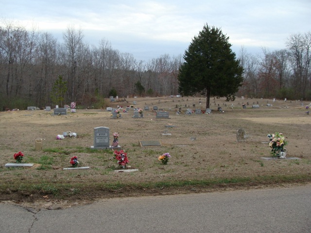
| Description | : | From the intersection of Oakgrove Rd. & US-64, in Selmer, travel north on Oakgrove Rd. for 0.6 mi., continuing onto Purdy Rd., going 0.3 mi. to the cemetery on the east (right) side, adjacent to the road & about 400' north of the Mt Zion MB Church. |
frequently asked questions (FAQ):
-
Where is Mount Zion MB Church Cemetery?
Mount Zion MB Church Cemetery is located at 965 Purdy Road Selmer, McNairy County ,Tennessee , 38375USA.
-
Mount Zion MB Church Cemetery cemetery's updated grave count on graveviews.com?
0 memorials
-
Where are the coordinates of the Mount Zion MB Church Cemetery?
Latitude: 35.1730920
Longitude: -88.5710370
Nearby Cemetories:
1. McCullar Family Cemetery
Selmer, McNairy County, USA
Coordinate: 35.1642580, -88.5716610
2. Warren Cemetery
Selmer, McNairy County, USA
Coordinate: 35.1775480, -88.5603820
3. Poor Farm Cemetery
McNairy County, USA
Coordinate: 35.1802990, -88.5564760
4. Oak Hill Cemetery
Selmer, McNairy County, USA
Coordinate: 35.1785650, -88.6008290
5. Bethesda Memorial Gardens
Selmer, McNairy County, USA
Coordinate: 35.1988880, -88.5709240
6. Fellowship Baptist Church Cemetery
Selmer, McNairy County, USA
Coordinate: 35.1519470, -88.5456420
7. Falcon Cemetery
Selmer, McNairy County, USA
Coordinate: 35.1420180, -88.5904980
8. Simpson-Wolfe Cemetery
Selmer, McNairy County, USA
Coordinate: 35.1644420, -88.6240660
9. Brooks Cemetery
Purdy, McNairy County, USA
Coordinate: 35.2082660, -88.5330580
10. Hope McNairy County Memorial Cemetery
Selmer, McNairy County, USA
Coordinate: 35.1221970, -88.5618700
11. Lake Hill Memory Gardens
Bethel Springs, McNairy County, USA
Coordinate: 35.2169810, -88.6048380
12. Union Grove Church Cemetery
Selmer, McNairy County, USA
Coordinate: 35.1463330, -88.5071040
13. Prospect Church Cemetery
Selmer, McNairy County, USA
Coordinate: 35.1453460, -88.5053200
14. Pleasant Grove Cemetery
Selmer, McNairy County, USA
Coordinate: 35.1116160, -88.5604710
15. Purdy Wright Cemetery
Purdy, McNairy County, USA
Coordinate: 35.2306570, -88.5403730
16. Chapel Hill Cemetery
Bethel Springs, McNairy County, USA
Coordinate: 35.2373190, -88.5663610
17. Motley Family Cemetery
Bethel Springs, McNairy County, USA
Coordinate: 35.2294220, -88.6108090
18. Bethel Springs Cemetery
Bethel Springs, McNairy County, USA
Coordinate: 35.2332380, -88.6066780
19. Purdy Wisdom Cemetery
Purdy, McNairy County, USA
Coordinate: 35.2343230, -88.5341050
20. Prather Cemetery
Selmer, McNairy County, USA
Coordinate: 35.0990860, -88.5695710
21. Sanders Cemetery #4
Stantonville, McNairy County, USA
Coordinate: 35.1793350, -88.4793370
22. Spring Hill Cemetery
Selmer, McNairy County, USA
Coordinate: 35.1193700, -88.5061040
23. Fink Cemetery
Purdy, McNairy County, USA
Coordinate: 35.1898540, -88.4780670
24. Pleasant Site Church Cemetery
Stantonville, McNairy County, USA
Coordinate: 35.1248340, -88.4950890