
| Memorials | : | 0 |
| Location | : | Rothenburg ob der Tauber, Landkreis Ansbach, Germany |
| Coordinate | : | 49.3843200, 10.1867210 |
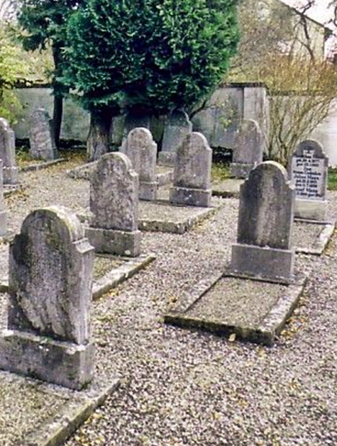
| Description | : | This is the second or newer Jewish cemetery in the city of Rothenburg. It is kept as a memorial, no new burials are taking place. The first Jewish cemetery in Rothenburg was established in the 14th century and used until 1520. It was turned into a Christian cemetery after that and eventually closed altogether and turned into a market square. The area maintained the name "Judenkirchhof" (Jewish Burial Ground) until 1958, when it was renamed Schrannenplatz. The New Jewish Cemetery was established in 1899 and used until 1938, when the Nazis in Germany destroyed it and the stones within. The Jewish congragation... Read More |
frequently asked questions (FAQ):
-
Where is Neuer jüdischer Friedhof Rothenburg?
Neuer jüdischer Friedhof Rothenburg is located at Wiesenstrasse Rothenburg ob der Tauber, Landkreis Ansbach ,Bavaria (Bayern) , 91541Germany.
-
Neuer jüdischer Friedhof Rothenburg cemetery's updated grave count on graveviews.com?
0 memorials
-
Where are the coordinates of the Neuer jüdischer Friedhof Rothenburg?
Latitude: 49.3843200
Longitude: 10.1867210
Nearby Cemetories:
1. Alter Friedhof Rothenburg
Rothenburg ob der Tauber, Landkreis Ansbach, Germany
Coordinate: 49.3754270, 10.1874910
2. Neuer Friedhof Rothenburg
Rothenburg ob der Tauber, Landkreis Ansbach, Germany
Coordinate: 49.3741670, 10.1865520
3. Franziskanerkloster Rothenburg o.d. Tauber
Rothenburg ob der Tauber, Landkreis Ansbach, Germany
Coordinate: 49.3766670, 10.1763890
4. Friedhof Sankt Leonhard
Rothenburg ob der Tauber, Landkreis Ansbach, Germany
Coordinate: 49.3619997, 10.1952344
5. Friedhof Neusitz
Neusitz, Landkreis Ansbach, Germany
Coordinate: 49.3714107, 10.2224423
6. Gebsattel
Gebsattel, Landkreis Ansbach, Germany
Coordinate: 49.3503735, 10.1932641
7. Friedhof Bockenfeld
Bockenfeld, Landkreis Ansbach, Germany
Coordinate: 49.3286696, 10.1967328
8. Friedhof Heiligenbronn
Heiligenbronn, Landkreis Schwäbisch Hall, Germany
Coordinate: 49.3794013, 10.0981218
9. Friedhof Diebach
Diebach, Landkreis Ansbach, Germany
Coordinate: 49.3093394, 10.1865778
10. Friedhof Insingen
Insingen, Landkreis Ansbach, Germany
Coordinate: 49.3033533, 10.1619194
11. Friedhof Ohrenbach
Ohrenbach, Landkreis Ansbach, Germany
Coordinate: 49.4691644, 10.2109335
12. Friedhof Gammesfeld
Gammesfeld, Landkreis Schwäbisch Hall, Germany
Coordinate: 49.3112540, 10.0948363
13. Friedhof Gastenfelden
Gastenfelden (Buch am Wald), Landkreis Ansbach, Germany
Coordinate: 49.3160642, 10.2959667
14. Friedhof Diebach-Oberoestheim
Oberoestheim, Landkreis Ansbach, Germany
Coordinate: 49.2861721, 10.2036907
15. Friedhof Hausen am Bach
Rot am See, Landkreis Schwäbisch Hall, Germany
Coordinate: 49.2959356, 10.1179181
16. Friedhof Archshofen
Archshofen, Main-Tauber-Kreis, Germany
Coordinate: 49.4529800, 10.0750300
17. Gailnau Cemetery
Untergailnau, Landkreis Ansbach, Germany
Coordinate: 49.2678533, 10.1887184
18. Friedhof Brettheim
Brettheim, Landkreis Schwäbisch Hall, Germany
Coordinate: 49.2782623, 10.0903073
19. Friedhof Marktbergel
Marktbergel, Landkreis Neustadt-Bad Windsheim, Germany
Coordinate: 49.4406240, 10.3596980
20. Friedhof Wettringen
Wettringen, Landkreis Ansbach, Germany
Coordinate: 49.2579900, 10.1574300
21. Friedhof Krailshausen
Krailshausen, Landkreis Schwäbisch Hall, Germany
Coordinate: 49.3665818, 9.9915662
22. Jüdischer Friedhof Ermetzhofen
Ermetzhofen, Landkreis Neustadt-Bad Windsheim, Germany
Coordinate: 49.5011699, 10.2782867
23. Friedhof Wörnitz
Wörnitz, Landkreis Ansbach, Germany
Coordinate: 49.2567417, 10.2422890
24. Friedhof Wildentierbach
Wildentierbach, Main-Tauber-Kreis, Germany
Coordinate: 49.3952860, 9.9825730