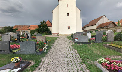
| Memorials | : | 0 |
| Location | : | Marktbergel, Landkreis Neustadt-Bad Windsheim, Germany |
| Coordinate | : | 49.4406240, 10.3596980 |
frequently asked questions (FAQ):
-
Where is Friedhof Marktbergel?
Friedhof Marktbergel is located at Marktbergel, Landkreis Neustadt-Bad Windsheim ,Bavaria (Bayern) ,Germany.
-
Friedhof Marktbergel cemetery's updated grave count on graveviews.com?
0 memorials
-
Where are the coordinates of the Friedhof Marktbergel?
Latitude: 49.4406240
Longitude: 10.3596980
Nearby Cemetories:
1. Friedhof Oberdachstetten
Oberdachstetten, Landkreis Ansbach, Germany
Coordinate: 49.4123330, 10.4262450
2. Friedhof Wiebelsheim (Bayern)
Wiebelsheim, Landkreis Neustadt-Bad Windsheim, Germany
Coordinate: 49.5010116, 10.3689109
3. Friedhof Bad Windsheim
Bad Windsheim, Landkreis Neustadt-Bad Windsheim, Germany
Coordinate: 49.4983360, 10.4132410
4. Jüdischer Friedhof Ermetzhofen
Ermetzhofen, Landkreis Neustadt-Bad Windsheim, Germany
Coordinate: 49.5011699, 10.2782867
5. Friedhof Colmberg
Colmberg, Landkreis Ansbach, Germany
Coordinate: 49.3531348, 10.4133476
6. Friedhof Ohrenbach
Ohrenbach, Landkreis Ansbach, Germany
Coordinate: 49.4691644, 10.2109335
7. Friedhof Gräfenbuch
Grafenbuch, Landkreis Ansbach, Germany
Coordinate: 49.3731206, 10.4759098
8. Friedhof Neusitz
Neusitz, Landkreis Ansbach, Germany
Coordinate: 49.3714107, 10.2224423
9. Neuer jüdischer Friedhof Rothenburg
Rothenburg ob der Tauber, Landkreis Ansbach, Germany
Coordinate: 49.3843200, 10.1867210
10. Alter Friedhof Rothenburg
Rothenburg ob der Tauber, Landkreis Ansbach, Germany
Coordinate: 49.3754270, 10.1874910
11. Neuer Friedhof Rothenburg
Rothenburg ob der Tauber, Landkreis Ansbach, Germany
Coordinate: 49.3741670, 10.1865520
12. Friedhof Gastenfelden
Gastenfelden (Buch am Wald), Landkreis Ansbach, Germany
Coordinate: 49.3160642, 10.2959667
13. Friedhof Sankt Leonhard
Rothenburg ob der Tauber, Landkreis Ansbach, Germany
Coordinate: 49.3619997, 10.1952344
14. Franziskanerkloster Rothenburg o.d. Tauber
Rothenburg ob der Tauber, Landkreis Ansbach, Germany
Coordinate: 49.3766670, 10.1763890
15. Gedenkstein für die Opfer der Gasexplosion
Lehrberg, Landkreis Ansbach, Germany
Coordinate: 49.3452310, 10.5098440
16. Friedhof Lehrberg
Lehrberg, Landkreis Ansbach, Germany
Coordinate: 49.3439220, 10.5120000
17. Friedhof Leutershausen Mittelfranken
Leutershausen, Landkreis Ansbach, Germany
Coordinate: 49.3031320, 10.4037171
18. Gebsattel
Gebsattel, Landkreis Ansbach, Germany
Coordinate: 49.3503735, 10.1932641
19. Friedhof Bockenfeld
Bockenfeld, Landkreis Ansbach, Germany
Coordinate: 49.3286696, 10.1967328
20. Friedhof Rügland
Rugland, Landkreis Ansbach, Germany
Coordinate: 49.4007652, 10.5924935
21. Friedhof Gollhofen
Gollhofen, Landkreis Neustadt-Bad Windsheim, Germany
Coordinate: 49.5679728, 10.1901900
22. Friedhof Weissenkirchberg-Brunst
Weissenkirchberg, Landkreis Ansbach, Germany
Coordinate: 49.2714885, 10.3384210
23. Friedhof Diebach
Diebach, Landkreis Ansbach, Germany
Coordinate: 49.3093394, 10.1865778
24. Friedhof Schloss Frankenberg
Weigenheim, Landkreis Neustadt-Bad Windsheim, Germany
Coordinate: 49.6092690, 10.2658930

