
| Memorials | : | 0 |
| Location | : | Nuneham Courtenay, South Oxfordshire District, England |
| Website | : | www.visitchurches.org.uk/visit/church-listing/all-saints-nuneham-courtenay.html |
| Coordinate | : | 51.6805300, -1.2181300 |
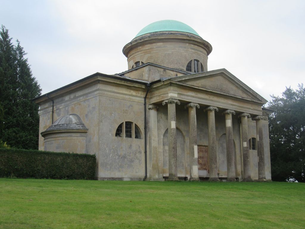
| Description | : | A gentleman's folly in a beautiful Thames-side setting This stunning church was built in the 1760s by Solicitor-General Simon Harcourt as part of the landscaped park for Nuneham Park House. Built to a classical design, with a gleaming dome and six slender columns, the church is as magnificent as its setting overlooking the Thames. Inside, All Saints is a monument to wealth and taste, with Italian fittings, magnificent memorial sculptures and busts. Look for the child among the bluebells - a beautiful and moving lifesize memorial. |
frequently asked questions (FAQ):
-
Where is Old All Saints Church?
Old All Saints Church is located at Nuneham Park,Nuneham Courtenay, Oxfordshire, England Nuneham Courtenay, South Oxfordshire District ,Oxfordshire , OX44 9PQEngland.
-
Old All Saints Church cemetery's updated grave count on graveviews.com?
0 memorials
-
Where are the coordinates of the Old All Saints Church?
Latitude: 51.6805300
Longitude: -1.2181300
Nearby Cemetories:
1. All Saints Parish Churchyard
Nuneham Courtenay, South Oxfordshire District, England
Coordinate: 51.6882380, -1.2057616
2. Radley Cemetery
Radley, Vale of White Horse District, England
Coordinate: 51.6893900, -1.2446800
3. St. James the Great Churchyard
Radley, Vale of White Horse District, England
Coordinate: 51.6907270, -1.2462510
4. St Peter Churchyard
Marsh Baldon, South Oxfordshire District, England
Coordinate: 51.6941870, -1.1884550
5. St Michael Churchyard
Clifton Hampden, South Oxfordshire District, England
Coordinate: 51.6558680, -1.2103840
6. Kennington Cemetery
Kennington, Vale of White Horse District, England
Coordinate: 51.7055400, -1.2397800
7. St. Andrew's Churchyard
Sandford-on-Thames, South Oxfordshire District, England
Coordinate: 51.7121430, -1.2289060
8. St Lawrence Churchyard
Toot Baldon, South Oxfordshire District, England
Coordinate: 51.7051720, -1.1750220
9. Our Lady and St Edmund of Abingdon Roman Catholic
Abingdon, Vale of White Horse District, England
Coordinate: 51.6747940, -1.2776270
10. St Mary the Virgin Churchyard
Long Wittenham, South Oxfordshire District, England
Coordinate: 51.6423650, -1.2092860
11. Abingdon Abbey (Defunct)
Abingdon, Vale of White Horse District, England
Coordinate: 51.6704790, -1.2783620
12. St Nicholas Church
Abingdon, Vale of White Horse District, England
Coordinate: 51.6702720, -1.2808640
13. St Mary and St Nicholas Churchyard
Littlemore, City of Oxford, England
Coordinate: 51.7210753, -1.2232272
14. Littlemore Chapel
Littlemore, City of Oxford, England
Coordinate: 51.7208320, -1.2270330
15. Abingdon War Memorial
Abingdon, Vale of White Horse District, England
Coordinate: 51.6702940, -1.2839070
16. Ss. Peter and Paul Churchyard
Appleford, Vale of White Horse District, England
Coordinate: 51.6396800, -1.2356090
17. St. Helen's Churchyard
Abingdon, Vale of White Horse District, England
Coordinate: 51.6672868, -1.2830793
18. Abingdon Baptist Church Burial Ground
Abingdon, Vale of White Horse District, England
Coordinate: 51.6700100, -1.2870810
19. St Leonard's Churchyard
Sunningwell, Vale of White Horse District, England
Coordinate: 51.7013600, -1.2840500
20. St. Paul's Churchyard
Culham, South Oxfordshire District, England
Coordinate: 51.6512320, -1.2762060
21. Dorchester Cemetery
Dorchester, South Oxfordshire District, England
Coordinate: 51.6478130, -1.1649480
22. St Mary the Virgin Churchyard
Iffley, City of Oxford, England
Coordinate: 51.7273590, -1.2381680
23. Spring Road Cemetery
Abingdon, Vale of White Horse District, England
Coordinate: 51.6722620, -1.2951410
24. St. Peter's Churchyard
Little Wittenham, South Oxfordshire District, England
Coordinate: 51.6369880, -1.1830625