
| Memorials | : | 0 |
| Location | : | Ryde, Isle of Wight Unitary Authority, England |
| Phone | : | 01983 882420 |
| Coordinate | : | 50.7310000, -1.1996000 |
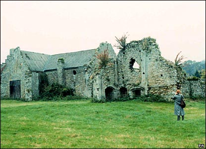
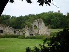
| Description | : | In 1131, Quarr was founded as a Savignac abbey, dedicated to the Blessed Virgin, by Baldwin II de Redvers (Réviers), Lord of the Isle of Wight and later Earl of Devon. The founder was buried in the Abbey in 1155, and his remains, along with those of a royal princess, Cecily of York (died 1507), second daughter of King Edward IV of England and godmother of Henry VIII, still lie on the site of the mediaeval monastery, as do other important personages. It was Cistercian from 1147 to 1536. After the Dissolution of the Monasteries in 1536, the... Read More |
frequently asked questions (FAQ):
-
Where is Quarr Old Abbey?
Quarr Old Abbey is located at Ryde, Isle of Wight Unitary Authority ,Isle of Wight , PO33 4ESEngland.
-
Quarr Old Abbey cemetery's updated grave count on graveviews.com?
0 memorials
-
Where are the coordinates of the Quarr Old Abbey?
Latitude: 50.7310000
Longitude: -1.1996000
Nearby Cemetories:
1. Quarr Abbey
Binstead, Isle of Wight Unitary Authority, England
Coordinate: 50.7311862, -1.2034333
2. Holy Cross Churchyard
Binstead, Isle of Wight Unitary Authority, England
Coordinate: 50.7320080, -1.1863070
3. Binstead Cemetery
Binstead, Isle of Wight Unitary Authority, England
Coordinate: 50.7264610, -1.1866180
4. Ryde Cemetery
Ryde, Isle of Wight Unitary Authority, England
Coordinate: 50.7249730, -1.1668550
5. St Peter's
Havenstreet, Isle of Wight Unitary Authority, England
Coordinate: 50.7095580, -1.2063290
6. St. Edmund's Churchyard
Wootton, Isle of Wight Unitary Authority, England
Coordinate: 50.7308220, -1.2344490
7. St Thomas Churchyard
Ryde, Isle of Wight Unitary Authority, England
Coordinate: 50.7305600, -1.1632540
8. St Cecilia's Abbey
Ryde, Isle of Wight Unitary Authority, England
Coordinate: 50.7279800, -1.1463120
9. St. Johns Churchyard
Ryde, Isle of Wight Unitary Authority, England
Coordinate: 50.7149770, -1.1482370
10. Isle of Wight Crematorium
Whippingham, Isle of Wight Unitary Authority, England
Coordinate: 50.7217910, -1.2573910
11. St. Mildred's Churchyard
Whippingham, Isle of Wight Unitary Authority, England
Coordinate: 50.7398230, -1.2768350
12. St Paul's Cemetery
Newport, Isle of Wight Unitary Authority, England
Coordinate: 50.7072300, -1.2827400
13. East Cowes Cemetery
East Cowes, Isle of Wight Unitary Authority, England
Coordinate: 50.7502300, -1.2876600
14. St Mary the Virgin Churchyard
Brading, Isle of Wight Unitary Authority, England
Coordinate: 50.6824400, -1.1429600
15. St James Churchyard
East Cowes, Isle of Wight Unitary Authority, England
Coordinate: 50.7579430, -1.2861300
16. Newport Cemetery
Newport, Isle of Wight Unitary Authority, England
Coordinate: 50.7041360, -1.2887540
17. St. Mark's Churchyard
Alverstoke, Gosport Borough, England
Coordinate: 50.7826800, -1.1436100
18. St Mary Churchyard
Alverstoke, Gosport Borough, England
Coordinate: 50.7856760, -1.1480810
19. St John the Baptist Church
Northwood, Isle of Wight Unitary Authority, England
Coordinate: 50.7340380, -1.3023130
20. Isle of Wight Workhouse Burial Ground
Carisbrooke, Isle of Wight Unitary Authority, England
Coordinate: 50.7112150, -1.2979810
21. Clayhall Naval Cemetery
Gosport, Gosport Borough, England
Coordinate: 50.7833862, -1.1373420
22. Turkish Naval Cemetery
Gosport, Gosport Borough, England
Coordinate: 50.7840710, -1.1383980
23. Northwood Cemetery
Cowes, Isle of Wight Unitary Authority, England
Coordinate: 50.7513700, -1.3003600
24. St Thomas Church
Newport, Isle of Wight Unitary Authority, England
Coordinate: 50.6997610, -1.2940130