
| Memorials | : | 0 |
| Location | : | Readtsjerk, Dantumadeel Municipality, Netherlands |
| Phone | : | +31 58-2562350 |
| Website | : | www.readtsjerkje.nl |
| Coordinate | : | 53.2562756, 5.9332706 |
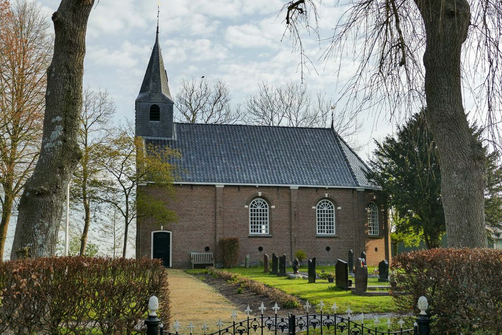
| Description | : | The church of Readtsjerk Around the year 1100 this church was founded by the episcopal Saint Martin's Church of Utrecht, and is therefore probably the oldest church in Friesland. It is a sober, Romanesque church, built on the spur of a sand ridge. In the Middle Ages, the church was surrounded by swamp and peatland, which was reclaimed by the monks of the Abbey of the Premontratensian Order in Dokkum. During the first five centuries, this church was a Roman Catholic chapel, dedicated to Saint Martin. After the Reformation in 1580, the church belonged to the Protestant churches until 1992. The... Read More |
frequently asked questions (FAQ):
-
Where is It Readtsjerkje hôf?
It Readtsjerkje hôf is located at Tsjerkewei 17 Readtsjerk, Dantumadeel Municipality ,Friesland ,Netherlands.
-
It Readtsjerkje hôf cemetery's updated grave count on graveviews.com?
0 memorials
-
Where are the coordinates of the It Readtsjerkje hôf?
Latitude: 53.2562756
Longitude: 5.9332706
Nearby Cemetories:
1. Marijetsjerke Begraafplaats
Oenkerk, Tytsjerksteradiel Municipality, Netherlands
Coordinate: 53.2537643, 5.8927362
2. Begraafplaats Aldtsjerk
Aldtsjerk, Tytsjerksteradiel Municipality, Netherlands
Coordinate: 53.2648500, 5.8887300
3. Feanwâlden Bûtefjild Cemetery
Feanwâlden, Dantumadeel Municipality, Netherlands
Coordinate: 53.2378864, 5.9815750
4. Rijperkerk Nederlands Hervormd Kerkhof
Rijperkerk, Tytsjerksteradiel Municipality, Netherlands
Coordinate: 53.2221200, 5.9183300
5. Giekerk Martinuskerk
Giekerk, Tytsjerksteradiel Municipality, Netherlands
Coordinate: 53.2411660, 5.8785276
6. Begraafplaats te Veenwouden Cemetery
Feanwâlden, Dantumadeel Municipality, Netherlands
Coordinate: 53.2390761, 5.9921180
7. Hoftsjerke begraafplaats
Hurdegaryp, Tytsjerksteradiel Municipality, Netherlands
Coordinate: 53.2175817, 5.9445193
8. Rêsthôf Broeksterwâld
Broeksterwoude, Dantumadeel Municipality, Netherlands
Coordinate: 53.2758766, 5.9907295
9. Kerkhof Alexanderkerk Rinsumageest
Rinsumageest, Dantumadeel Municipality, Netherlands
Coordinate: 53.2959488, 5.9429579
10. Akkerwoude Protestant Churchyard
Akkerwoude, Dantumadeel Municipality, Netherlands
Coordinate: 53.2909300, 5.9779800
11. Damwoude General Cemetery
Damwâld, Dantumadeel Municipality, Netherlands
Coordinate: 53.2857700, 5.9996900
12. Begraafplaats Sint-Vituskerk
Tytsjerk, Tytsjerksteradiel Municipality, Netherlands
Coordinate: 53.2062242, 5.9142663
13. Kloosterkapel begraafplaats
Sibrandahûs, Dantumadeel Municipality, Netherlands
Coordinate: 53.3111878, 5.9425346
14. Begraafplaats De Westereen
Zwaagwesteinde, Dantumadeel Municipality, Netherlands
Coordinate: 53.2497819, 6.0273741
15. Tsjerkhôf Jannum
Jannum, Ferwerderadiel Municipality, Netherlands
Coordinate: 53.3126308, 5.9027619
16. Sint-Vituskerk
Wyns, Tytsjerksteradiel Municipality, Netherlands
Coordinate: 53.2516880, 5.8322860
17. Kerkhof Nederlands Hervormde kerk De Westereen
Zwaagwesteinde, Dantumadeel Municipality, Netherlands
Coordinate: 53.2583297, 6.0348107
18. Begraafplaats Zwaagwesteinde
Zwaagwesteinde, Dantumadeel Municipality, Netherlands
Coordinate: 53.2580833, 6.0351062
19. Kerkhof Petruskerk
Wanswerd, Ferwerderadiel Municipality, Netherlands
Coordinate: 53.3009375, 5.8496879
20. Raard Protestant Churchyard
Raard, Dongeradeel Municipality, Netherlands
Coordinate: 53.3254600, 5.9444900
21. Petruskerkhof
Lichtaard, Ferwerderadiel Municipality, Netherlands
Coordinate: 53.3263379, 5.9135862
22. Begraafplaats Twijzelerheide
Twijzelerheide, Achtkarspelen Municipality, Netherlands
Coordinate: 53.2413444, 6.0525175
23. Bergum Protestant Churchyard
Bergum, Tytsjerksteradiel Municipality, Netherlands
Coordinate: 53.1958500, 6.0016300
24. Lekkum Churchyard
Lekkum, Leeuwarden Municipality, Netherlands
Coordinate: 53.2263300, 5.8194900