
| Memorials | : | 0 |
| Location | : | Mills County, USA |
| Coordinate | : | 41.1255500, -95.7725000 |
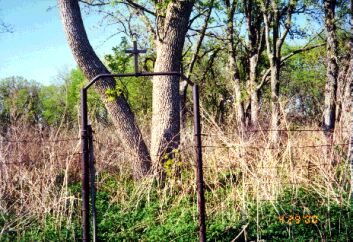
| Description | : | This cemetery was established on the farm once owned by Henry and Sophia (Plumer) Saar, now on the Van Pelt farm on Highway 275 and the Mineola Road in the Northeast Quarter of Section 15 , Oak Township. It is fenced and there is a metal arch with a cross over the gateway. Earlier burials in Plumer Settlement were made in this cemetery which is 67 by 54 feet and was platted for 65 lots. However, when the Salem Lutheran Church was built to the north, the Plumer Settlement (Salem Lutheran) Cemetery was established across the... Read More |
frequently asked questions (FAQ):
-
Where is Saar's Field Cemetery?
Saar's Field Cemetery is located at Mills County ,Iowa ,USA.
-
Saar's Field Cemetery cemetery's updated grave count on graveviews.com?
0 memorials
-
Where are the coordinates of the Saar's Field Cemetery?
Latitude: 41.1255500
Longitude: -95.7725000
Nearby Cemetories:
1. Saint Boniface Catholic Cemetery
Mills County, USA
Coordinate: 41.1419000, -95.7467100
2. Salem Lutheran Church Cemetery
Glenwood, Mills County, USA
Coordinate: 41.1556015, -95.7617035
3. West Liberty Cemetery
Glenwood, Mills County, USA
Coordinate: 41.0956001, -95.7536011
4. Wall Cemetery
Mineola, Mills County, USA
Coordinate: 41.1157990, -95.8153000
5. Saint Pauls Evangelical Country Church Cemetery
Dumfries, Pottawattamie County, USA
Coordinate: 41.1748352, -95.7492371
6. Gowens-Turner Cemetery
Glenwood, Mills County, USA
Coordinate: 41.0715510, -95.7952420
7. Mineola Cemetery
Mineola, Mills County, USA
Coordinate: 41.1391130, -95.6941800
8. Godsey Cemetery
Mills County, USA
Coordinate: 41.0705986, -95.8075027
9. Zion Cemetery
Pottawattamie County, USA
Coordinate: 41.1778000, -95.7272000
10. Saint Marys Cemetery
Mills County, USA
Coordinate: 41.1517580, -95.8514000
11. Martin Chapel Cemetery
Pacific City, Mills County, USA
Coordinate: 41.0611000, -95.8013992
12. Glenwood Cemetery
Glenwood, Mills County, USA
Coordinate: 41.0599670, -95.7480240
13. Glenwood Catholic Cemetery
Glenwood, Mills County, USA
Coordinate: 41.0600000, -95.7453000
14. Lewis Township Cemetery
Council Bluffs, Pottawattamie County, USA
Coordinate: 41.2117004, -95.7938995
15. Keg Creek Township Cemetery
Treynor, Pottawattamie County, USA
Coordinate: 41.1913986, -95.6893997
16. Moscrip Cemetery
Bellevue, Sarpy County, USA
Coordinate: 41.1413500, -95.8917000
17. Glenwood Resource Center Cemetery
Glenwood, Mills County, USA
Coordinate: 41.0361720, -95.7338590
18. Bellevue Cemetery
Bellevue, Sarpy County, USA
Coordinate: 41.1492004, -95.8944016
19. Fontenelle Forest Cemetery
Bellevue, Sarpy County, USA
Coordinate: 41.1636430, -95.8887200
20. Columban Martyrs Memorial Garden
Bellevue, Sarpy County, USA
Coordinate: 41.1403220, -95.9034390
21. Offutt AFB Cemetery
Sarpy County, USA
Coordinate: 41.1325607, -95.9096451
22. Silver City Cemetery
Silver City, Mills County, USA
Coordinate: 41.1042442, -95.6380005
23. Bomar Family Cemetery
Mills County, USA
Coordinate: 41.0369400, -95.6941700
24. Maple Grove Cemetery
Council Bluffs, Pottawattamie County, USA
Coordinate: 41.2265560, -95.8187100