
| Memorials | : | 0 |
| Location | : | Redmarshall, Stockton-on-Tees Unitary Authority, England |
| Coordinate | : | 54.5840600, -1.4037700 |
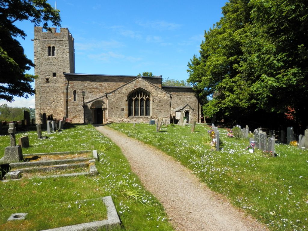
| Description | : | St Cuthbert's Parish Church stands on the north side of the small village of Redmarshall, with the lane from Bishopton to Carlton forming the northern boundary of the churchyard. The church stands on a slight eminence and its tower commands extensive views across the low-lying land around the mouth of the Tees. Of the original 12th-century church the nave and tower remain, but the chancel was rebuilt in its present form in the latter part of the 13th century. The south chapel, representing the chantry of St. Mary, and later known as the Claxton porch, is an addition of the 15th... Read More |
frequently asked questions (FAQ):
-
Where is Saint Cuthbert's Churchyard?
Saint Cuthbert's Churchyard is located at Redmarshall, Stockton-on-Tees Unitary Authority ,County Durham ,England.
-
Saint Cuthbert's Churchyard cemetery's updated grave count on graveviews.com?
0 memorials
-
Where are the coordinates of the Saint Cuthbert's Churchyard?
Latitude: 54.5840600
Longitude: -1.4037700
Nearby Cemetories:
1. St. Peter's Churchyard
Bishopton, Darlington Unitary Authority, England
Coordinate: 54.5852070, -1.4368680
2. St John's Churchyard
Stillington, Stockton-on-Tees Unitary Authority, England
Coordinate: 54.6064000, -1.4173000
3. St. James' Churchyard
Thorpe Thewles, Stockton-on-Tees Unitary Authority, England
Coordinate: 54.6051920, -1.3790430
4. St. John's Churchyard
Elton, Stockton-on-Tees Unitary Authority, England
Coordinate: 54.5500830, -1.3803290
5. St. Thomas a Becket Churchyard
Thorpe Thewles, Stockton-on-Tees Unitary Authority, England
Coordinate: 54.6224980, -1.3854178
6. St. Mary's Churchyard
Long Newton, Stockton-on-Tees Unitary Authority, England
Coordinate: 54.5417700, -1.4098500
7. Durham Road Cemetery
Stockton-on-Tees, Stockton-on-Tees Unitary Authority, England
Coordinate: 54.5754110, -1.3283100
8. All Saints Churchyard
Great Stainton, Darlington Unitary Authority, England
Coordinate: 54.5936200, -1.4818800
9. Oxbridge Lane Cemetery
Stockton-on-Tees, Stockton-on-Tees Unitary Authority, England
Coordinate: 54.5617050, -1.3319520
10. St. Mary the Virgin Churchyard
Norton, Stockton-on-Tees Unitary Authority, England
Coordinate: 54.5924790, -1.3163220
11. St Thomas Churchyard
Stockton-on-Tees, Stockton-on-Tees Unitary Authority, England
Coordinate: 54.5665430, -1.3123540
12. St Andrew Churchyard
Sadberge, Darlington Unitary Authority, England
Coordinate: 54.5453890, -1.4744810
13. Holy Trinity Churchyard
Stockton-on-Tees, Stockton-on-Tees Unitary Authority, England
Coordinate: 54.5603000, -1.3151000
14. Preston-on-Tees Municipal Cemetery
Stockton-on-Tees Unitary Authority, England
Coordinate: 54.5422400, -1.3367300
15. St Cuthbert Churchyard
Billingham, Stockton-on-Tees Unitary Authority, England
Coordinate: 54.5941830, -1.2931180
16. St Paul Churchyard
Thornaby on Tees, Stockton-on-Tees Unitary Authority, England
Coordinate: 54.5517940, -1.3048610
17. St. Peter ad Vincula Churchyard
Thornaby on Tees, Stockton-on-Tees Unitary Authority, England
Coordinate: 54.5412998, -1.3044432
18. Sedgefield Old Cemetery
Sedgefield, Durham Unitary Authority, England
Coordinate: 54.6527050, -1.4416632
19. St. Peter's Churchyard
Wolviston, Stockton-on-Tees Unitary Authority, England
Coordinate: 54.6250820, -1.2977740
20. St Edmund Churchyard
Sedgefield, Durham Unitary Authority, England
Coordinate: 54.6532480, -1.4485160
21. Sedgefield New Cemetery
Sedgefield, Durham Unitary Authority, England
Coordinate: 54.6557900, -1.4447300
22. Egglescliffe Cemetery
Egglescliffe, Stockton-on-Tees Unitary Authority, England
Coordinate: 54.5127200, -1.3520100
23. St. John the Baptist Churchyard
Egglescliffe, Stockton-on-Tees Unitary Authority, England
Coordinate: 54.5121000, -1.3518000
24. Thornaby Cemetery
Thornaby on Tees, Stockton-on-Tees Unitary Authority, England
Coordinate: 54.5492000, -1.2826740