
| Memorials | : | 0 |
| Location | : | Thorpe Thewles, Stockton-on-Tees Unitary Authority, England |
| Coordinate | : | 54.6224980, -1.3854178 |
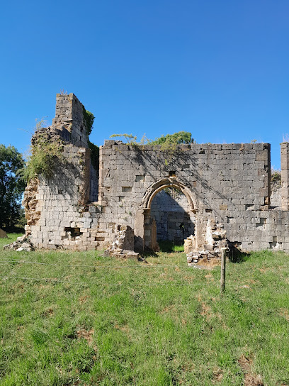
| Description | : | NZ 32 NE GRINDON DURHAM ROAD (off) (East side) 1/500 Ruins of Church of St Thomas A Becket 16.11.67 1 Statutory Address: RUINS OF A CHURCH OF ST THOMAS A BECKET, DURHAM ROAD The building or site itself may lie within the boundary of more than one authority. District: Stockton-on-Tees (Unitary Authority) Parish: Grindon National Grid Reference: NZ3978125435 The original parish church at Grindon is Norman in origin (1153 – 1193) and was dedicated to St Thomas a Becket. The church was consecrated by Hugh de Puiset, Bishop of Durham and great grandson of William the Conqueror. It stands in a field in Grindon and is now on private land.... Read More |
frequently asked questions (FAQ):
-
Where is St. Thomas a Becket Churchyard?
St. Thomas a Becket Churchyard is located at Statutory Address: RUINS OF A CHURCH OF ST THOMAS A BECKET, DURHAM ROAD Thorpe Thewles, Stockton-on-Tees Unitary Authority ,County Durham ,England.
-
St. Thomas a Becket Churchyard cemetery's updated grave count on graveviews.com?
0 memorials
-
Where are the coordinates of the St. Thomas a Becket Churchyard?
Latitude: 54.6224980
Longitude: -1.3854178
Nearby Cemetories:
1. St. James' Churchyard
Thorpe Thewles, Stockton-on-Tees Unitary Authority, England
Coordinate: 54.6051920, -1.3790430
2. St John's Churchyard
Stillington, Stockton-on-Tees Unitary Authority, England
Coordinate: 54.6064000, -1.4173000
3. Saint Cuthbert's Churchyard
Redmarshall, Stockton-on-Tees Unitary Authority, England
Coordinate: 54.5840600, -1.4037700
4. Sedgefield Old Cemetery
Sedgefield, Durham Unitary Authority, England
Coordinate: 54.6527050, -1.4416632
5. St. Peter's Churchyard
Bishopton, Darlington Unitary Authority, England
Coordinate: 54.5852070, -1.4368680
6. St Edmund Churchyard
Sedgefield, Durham Unitary Authority, England
Coordinate: 54.6532480, -1.4485160
7. Sedgefield New Cemetery
Sedgefield, Durham Unitary Authority, England
Coordinate: 54.6557900, -1.4447300
8. St. Mary the Virgin Churchyard
Norton, Stockton-on-Tees Unitary Authority, England
Coordinate: 54.5924790, -1.3163220
9. St. Peter's Churchyard
Wolviston, Stockton-on-Tees Unitary Authority, England
Coordinate: 54.6250820, -1.2977740
10. Durham Road Cemetery
Stockton-on-Tees, Stockton-on-Tees Unitary Authority, England
Coordinate: 54.5754110, -1.3283100
11. Winterton Hospital Cemetery
Sedgefield, Durham Unitary Authority, England
Coordinate: 54.6677800, -1.4471800
12. St Cuthbert Churchyard
Billingham, Stockton-on-Tees Unitary Authority, England
Coordinate: 54.5941830, -1.2931180
13. All Saints Churchyard
Great Stainton, Darlington Unitary Authority, England
Coordinate: 54.5936200, -1.4818800
14. Oxbridge Lane Cemetery
Stockton-on-Tees, Stockton-on-Tees Unitary Authority, England
Coordinate: 54.5617050, -1.3319520
15. Fishburn Cemetery
Fishburn, Durham Unitary Authority, England
Coordinate: 54.6847100, -1.4397300
16. Billingham Cemetery
Billingham, Stockton-on-Tees Unitary Authority, England
Coordinate: 54.6177010, -1.2650780
17. St Thomas Churchyard
Stockton-on-Tees, Stockton-on-Tees Unitary Authority, England
Coordinate: 54.5665430, -1.3123540
18. St. John's Churchyard
Elton, Stockton-on-Tees Unitary Authority, England
Coordinate: 54.5500830, -1.3803290
19. Holy Trinity Churchyard
Stockton-on-Tees, Stockton-on-Tees Unitary Authority, England
Coordinate: 54.5603000, -1.3151000
20. St Peter's Churchyard
Elwick, Hartlepool Unitary Authority, England
Coordinate: 54.6813620, -1.2982740
21. Saint Michael Churchyard
Bishop Middleham, Durham Unitary Authority, England
Coordinate: 54.6754810, -1.4931890
22. St John Haverton Hill Churchyard
Haverton Hill, Stockton-on-Tees Unitary Authority, England
Coordinate: 54.5961580, -1.2516480
23. St. Mary's Churchyard
Long Newton, Stockton-on-Tees Unitary Authority, England
Coordinate: 54.5417700, -1.4098500
24. St Paul Churchyard
Thornaby on Tees, Stockton-on-Tees Unitary Authority, England
Coordinate: 54.5517940, -1.3048610