
| Memorials | : | 7 |
| Location | : | New Haven, Franklin County, USA |
| Coordinate | : | 38.5459500, -91.3678600 |
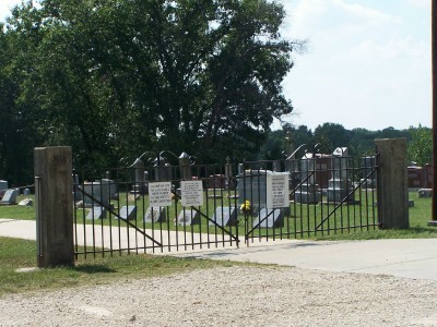
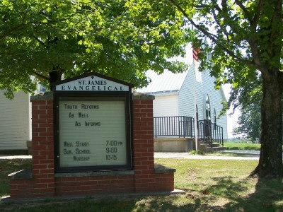
| Description | : | This cemetery was originally associated with the St. James United Church of Christ, now known as the St. James Evangelical Church. The cemetery is known by funeral homes, newspapers and local residents simply as "St. James Cemetery". The church and cemetery is physically in Franklin County, with a street and mailing address of 4310 Highway E, New Haven, MO (9 miles northeast) although it has always had a community affiliation with Stony Hill, MO, which is 1/2 mile to the west in Gasconade County. |
frequently asked questions (FAQ):
-
Where is Saint James Cemetery?
Saint James Cemetery is located at Stony Hill, MO(44N. R.4W. Sec. 22) New Haven, Franklin County ,Missouri ,USA.
-
Saint James Cemetery cemetery's updated grave count on graveviews.com?
6 memorials
-
Where are the coordinates of the Saint James Cemetery?
Latitude: 38.5459500
Longitude: -91.3678600

Nearby Cemetories:
1. Roth Cemetery
Gasconade County, USA
Coordinate: 38.5705986, -91.3886032
2. Mann Cemetery
Gasconade County, USA
Coordinate: 38.5321999, -91.4057999
3. Kohlbush Cemetery
Franklin County, USA
Coordinate: 38.5741997, -91.3330994
4. Kohlbusch Family Cemetery
New Haven, Franklin County, USA
Coordinate: 38.5747430, -91.3323930
5. Hoemann Cemetery
Detmold, Franklin County, USA
Coordinate: 38.5343500, -91.3185400
6. Helling Cemetery
Franklin County, USA
Coordinate: 38.5710983, -91.3202972
7. Dahl Cemetery
Gasconade County, USA
Coordinate: 38.5910988, -91.3728027
8. Von Behren Family Cemetery
Kohl City, Franklin County, USA
Coordinate: 38.5959770, -91.3645790
9. Smith Cemetery of Senate Grove
Berger, Franklin County, USA
Coordinate: 38.5833000, -91.3237800
10. Ebenezer Stone Church Cemetery
Gerald, Franklin County, USA
Coordinate: 38.5043182, -91.3180161
11. Detmold Cemetery
Detmold, Franklin County, USA
Coordinate: 38.5385000, -91.2935300
12. Senate Grove Cemetery
Berger, Franklin County, USA
Coordinate: 38.5959000, -91.3265000
13. Meyers Cemetery
Franklin County, USA
Coordinate: 38.5839005, -91.3047028
14. Meyer Family Cemetery
New Haven, Franklin County, USA
Coordinate: 38.5831929, -91.3034617
15. Beemont United Methodist Cemetery
Owensville, Gasconade County, USA
Coordinate: 38.4844398, -91.3830566
16. Schroeder Cemetery
Beemont, Franklin County, USA
Coordinate: 38.4897000, -91.3295600
17. Freese Cemetery
Kohl City, Franklin County, USA
Coordinate: 38.6002370, -91.3243680
18. New Hope Missionary Baptist Church Cemetery
Beemont, Franklin County, USA
Coordinate: 38.4813770, -91.3595580
19. Meyer Family Cemetery
Gasconade County, USA
Coordinate: 38.4723700, -91.3681400
20. Bethany Evangelical Cemetery
Berger, Franklin County, USA
Coordinate: 38.6253100, -91.3642500
21. Hempelmann Cemetery
New Haven, Franklin County, USA
Coordinate: 38.6036500, -91.2954300
22. Kahle Cemetery
Gasconade County, USA
Coordinate: 38.5475006, -91.4730988
23. Sattler's Cemetery
Gasconade County, USA
Coordinate: 38.5476870, -91.4733320
24. Stoecklin Cemetery
Gasconade County, USA
Coordinate: 38.6178017, -91.4242020