
| Memorials | : | 0 |
| Location | : | Beemont, Franklin County, USA |
| Coordinate | : | 38.4813770, -91.3595580 |
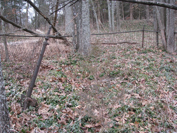
| Description | : | New Hope Missionary Baptist Church was organized in 1858 by Elder Peter Williams. In 1860 a log building was erected and in 1882 a new frame building was built and dedicated by Elder J. C. Armstrong. Pastors up until 1888 included J. D. Murphy, L. M. Mahanay and William Bridges. Membership of the church in 1888 was seventy eight. There is no evidence remaining of this church except for its small cemetery which is untended and overgrown. The entire area is blanketed with periwinkle. Once fenced, the fence is now mostly down making for... Read More |
frequently asked questions (FAQ):
-
Where is New Hope Missionary Baptist Church Cemetery?
New Hope Missionary Baptist Church Cemetery is located at Highway ZZ and Beemont Road Beemont, Franklin County ,Missouri ,USA.
-
New Hope Missionary Baptist Church Cemetery cemetery's updated grave count on graveviews.com?
0 memorials
-
Where are the coordinates of the New Hope Missionary Baptist Church Cemetery?
Latitude: 38.4813770
Longitude: -91.3595580
Nearby Cemetories:
1. Meyer Family Cemetery
Gasconade County, USA
Coordinate: 38.4723700, -91.3681400
2. Beemont United Methodist Cemetery
Owensville, Gasconade County, USA
Coordinate: 38.4844398, -91.3830566
3. Schroeder Cemetery
Beemont, Franklin County, USA
Coordinate: 38.4897000, -91.3295600
4. Georgetown Cemetery
Gasconade County, USA
Coordinate: 38.4608002, -91.3786011
5. Ebenezer Stone Church Cemetery
Gerald, Franklin County, USA
Coordinate: 38.5043182, -91.3180161
6. Stevens Cemetery
Gerald, Franklin County, USA
Coordinate: 38.4644700, -91.3099700
7. Schroeder Cemetery
Gasconade County, USA
Coordinate: 38.4536018, -91.4047012
8. Cedar Fork United Baptist Church #2
Gerald, Franklin County, USA
Coordinate: 38.4283500, -91.3499200
9. Cedar Fork United Baptist Church #1
Gerald, Franklin County, USA
Coordinate: 38.4284100, -91.3373500
10. Hoemann Cemetery
Detmold, Franklin County, USA
Coordinate: 38.5343500, -91.3185400
11. Mann Cemetery
Gasconade County, USA
Coordinate: 38.5321999, -91.4057999
12. Saint James Cemetery
New Haven, Franklin County, USA
Coordinate: 38.5459500, -91.3678600
13. Bridges Family Cemetery
Franklin County, USA
Coordinate: 38.4681100, -91.2778300
14. Sprick Family Cemetery
Port Hudson, Franklin County, USA
Coordinate: 38.4682100, -91.2692400
15. Koirtyohann-Bates Family Cemetery
Gerald, Franklin County, USA
Coordinate: 38.4286003, -91.2941971
16. Saint John Lutheran Church Cemetery
Owensville, Gasconade County, USA
Coordinate: 38.4457800, -91.4428100
17. Neely Family Cemetery
Port Hudson, Franklin County, USA
Coordinate: 38.4564100, -91.2692600
18. Malvern Cemetery
Port Hudson, Franklin County, USA
Coordinate: 38.4560400, -91.2689600
19. Saint James UCC Cemetery
Drake, Gasconade County, USA
Coordinate: 38.4419950, -91.4420980
20. Detmold Cemetery
Detmold, Franklin County, USA
Coordinate: 38.5385000, -91.2935300
21. Evangelical Saint Paul Cemetery
Gerald, Franklin County, USA
Coordinate: 38.4105988, -91.3106003
22. Boeuff Cemetery
Gerald, Franklin County, USA
Coordinate: 38.3944016, -91.3450012
23. Schuett Cemetery
Port Hudson, Franklin County, USA
Coordinate: 38.4680700, -91.2463600
24. Immanuel Cemetery
Gasconade County, USA
Coordinate: 38.4460983, -91.4677963