
| Memorials | : | 0 |
| Location | : | Gasconade County, USA |
| Coordinate | : | 38.4723700, -91.3681400 |
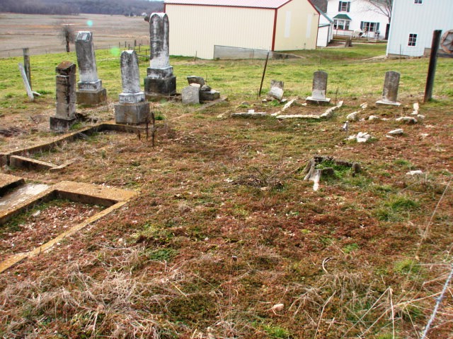
| Description | : | Family cemetery visible from Pin Oak Road on the present day (2012) Kopp farm alongside driveway near farm buildings. Maintained by property owner. Some stones are broken or crumbling. Two graves are marked by concrete coping only, but evidently once had temporary metal markers, the stubs of which are visible in the concrete. |
frequently asked questions (FAQ):
-
Where is Meyer Family Cemetery?
Meyer Family Cemetery is located at Pin Oak Road, just off Highway ZZ Gasconade County ,Missouri ,USA.
-
Meyer Family Cemetery cemetery's updated grave count on graveviews.com?
0 memorials
-
Where are the coordinates of the Meyer Family Cemetery?
Latitude: 38.4723700
Longitude: -91.3681400
Nearby Cemetories:
1. New Hope Missionary Baptist Church Cemetery
Beemont, Franklin County, USA
Coordinate: 38.4813770, -91.3595580
2. Georgetown Cemetery
Gasconade County, USA
Coordinate: 38.4608002, -91.3786011
3. Beemont United Methodist Cemetery
Owensville, Gasconade County, USA
Coordinate: 38.4844398, -91.3830566
4. Schroeder Cemetery
Gasconade County, USA
Coordinate: 38.4536018, -91.4047012
5. Schroeder Cemetery
Beemont, Franklin County, USA
Coordinate: 38.4897000, -91.3295600
6. Stevens Cemetery
Gerald, Franklin County, USA
Coordinate: 38.4644700, -91.3099700
7. Cedar Fork United Baptist Church #2
Gerald, Franklin County, USA
Coordinate: 38.4283500, -91.3499200
8. Cedar Fork United Baptist Church #1
Gerald, Franklin County, USA
Coordinate: 38.4284100, -91.3373500
9. Ebenezer Stone Church Cemetery
Gerald, Franklin County, USA
Coordinate: 38.5043182, -91.3180161
10. Saint John Lutheran Church Cemetery
Owensville, Gasconade County, USA
Coordinate: 38.4457800, -91.4428100
11. Saint James UCC Cemetery
Drake, Gasconade County, USA
Coordinate: 38.4419950, -91.4420980
12. Mann Cemetery
Gasconade County, USA
Coordinate: 38.5321999, -91.4057999
13. Bridges Family Cemetery
Franklin County, USA
Coordinate: 38.4681100, -91.2778300
14. Koirtyohann-Bates Family Cemetery
Gerald, Franklin County, USA
Coordinate: 38.4286003, -91.2941971
15. Hoemann Cemetery
Detmold, Franklin County, USA
Coordinate: 38.5343500, -91.3185400
16. Saint James Cemetery
New Haven, Franklin County, USA
Coordinate: 38.5459500, -91.3678600
17. Evangelical Saint Paul Cemetery
Gerald, Franklin County, USA
Coordinate: 38.4105988, -91.3106003
18. Sprick Family Cemetery
Port Hudson, Franklin County, USA
Coordinate: 38.4682100, -91.2692400
19. Neely Family Cemetery
Port Hudson, Franklin County, USA
Coordinate: 38.4564100, -91.2692600
20. Malvern Cemetery
Port Hudson, Franklin County, USA
Coordinate: 38.4560400, -91.2689600
21. Boeuff Cemetery
Gerald, Franklin County, USA
Coordinate: 38.3944016, -91.3450012
22. Immanuel Cemetery
Gasconade County, USA
Coordinate: 38.4460983, -91.4677963
23. Methodist Cemetery
Rosebud, Gasconade County, USA
Coordinate: 38.3917660, -91.3999690
24. Detmold Cemetery
Detmold, Franklin County, USA
Coordinate: 38.5385000, -91.2935300