
| Memorials | : | 14 |
| Location | : | Barbados |
| Coordinate | : | 13.2919100, -59.6235800 |
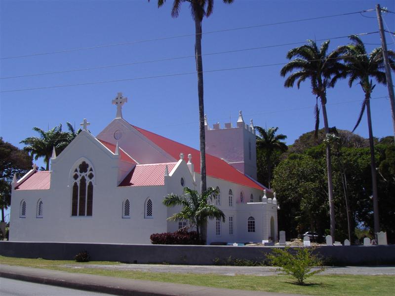
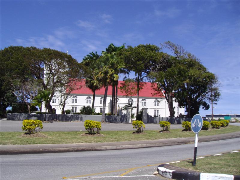
| Description | : | St. Lucy is one of the six parishes created by Governor Sir William Tufton and the first Church was in existence in 1629. It was built of timber and was destroyed by a hurricane. The second Church was built in 1741 of sawn stone. This was destroyed by the hurricane of 1780. The third Church was also destroyed by hurricane in 1831. The present Church was built in 1837, and is essentially Georgian, with a tower which conforms to the characteristic of all the other Parish Churches rebuilt during this period. It has a gallery running continuously... Read More |
frequently asked questions (FAQ):
-
Where is Saint Lucy Parish Church Cemetery?
Saint Lucy Parish Church Cemetery is located at near Sir Theodore Brancker roundabout, C D O'Neal Highway at Hwy 1C, St. Lucy Parish Saint Lucy ,Barbados.
-
Saint Lucy Parish Church Cemetery cemetery's updated grave count on graveviews.com?
12 memorials
-
Where are the coordinates of the Saint Lucy Parish Church Cemetery?
Latitude: 13.2919100
Longitude: -59.6235800
Nearby Cemetories:
1. All Saints Chapel Burial Ground
Barbados
Coordinate: 13.2696800, -59.6125200
2. Saint Philip-the-Less Churchyard
Barbados
Coordinate: 13.2842700, -59.5821100
3. Mangrove Plantation Estate Cemetery
Barbados
Coordinate: 13.2349700, -59.6172900
4. Saint Andrew Parish Church Cemetery
Barbados
Coordinate: 13.2526700, -59.5678600
5. Saint James Parish Church and Cemetery
Barbados
Coordinate: 13.1908600, -59.6381500
6. Saint Thomas Parish Church Cemetery
Barbados
Coordinate: 13.1858900, -59.6129200
7. Holy Innocents Church Graveyard
Barbados
Coordinate: 13.1826710, -59.5811000
8. Saint Joseph Parish Church Cemetery
Barbados
Coordinate: 13.2010490, -59.5393320
9. Newcastle Plantation Estate
Barbados
Coordinate: 13.1938400, -59.5001400
10. Saint George Parish Church Cemetery
Barbados
Coordinate: 13.1311300, -59.5639400
11. Saint David's Churchyard
Barbados
Coordinate: 13.1311300, -59.5639400
12. Saint Johns Parish Church Cemetery
Barbados
Coordinate: 13.1840296, -59.4721794
13. Saint Leonards Anglican Church Cemetery
Barbados
Coordinate: 13.1059010, -59.6191760
14. Saint Matthews Anglican Church Cemetery
Barbados
Coordinate: 13.1045160, -59.5790290
15. Saint Philip Parish Church Cemetery
Barbados
Coordinate: 13.1366770, -59.4887670
16. Garrison Military Cemetery
Barbados
Coordinate: 13.0791530, -59.6098530
17. Coral Ridge Memorial Gardens
Barbados
Coordinate: 13.0973640, -59.5254600
18. Saint Mathias Church Memorial Garden
Barbados
Coordinate: 13.0761570, -59.5994940
19. Christ Church Parish Church
Barbados
Coordinate: 13.0651820, -59.5381840
20. Choc Bay War Cemetery
Saint Lucia
Coordinate: 14.0225200, -60.9861370
21. Castries City Cemetery
Saint Lucia
Coordinate: 14.0224370, -60.9869960
22. San Chez Cemetery
Grenada
Coordinate: 12.5247260, -61.3865720
23. Tibeau Cemetery
Grenada
Coordinate: 12.4973638, -61.4237995
24. Grand Bay Cemetery
Grenada
Coordinate: 12.4714613, -61.4349142