
| Memorials | : | 2 |
| Location | : | Crockett Mills, Crockett County, USA |
| Coordinate | : | 35.9096750, -89.1609030 |
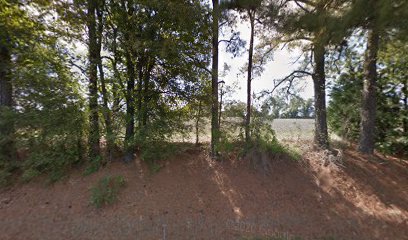
| Description | : | From the intersection of TN-188 N & TN-152 W, south of Crockett Mills, travel north on TN-188 for 5.3 mi. to the cemetery on the west (left) side of the road, about 800' across a cultivated field, under a large tree. |
frequently asked questions (FAQ):
-
Where is Sanders Cemetery?
Sanders Cemetery is located at 7973 TN-188 Crockett Mills, Crockett County ,Tennessee ,USA.
-
Sanders Cemetery cemetery's updated grave count on graveviews.com?
0 memorials
-
Where are the coordinates of the Sanders Cemetery?
Latitude: 35.9096750
Longitude: -89.1609030
Nearby Cemetories:
1. Warren Cemetery
Crockett Mills, Crockett County, USA
Coordinate: 35.9074790, -89.1521770
2. Providence Baptist Church Cemetery
Crockett Mills, Crockett County, USA
Coordinate: 35.8839830, -89.1595080
3. Asprey Cemetery
Crockett Mills, Crockett County, USA
Coordinate: 35.8844990, -89.1532570
4. Bethesda Cemetery
Wilcox, Crockett County, USA
Coordinate: 35.9361230, -89.1557970
5. Lanier Cemetery
Crockett Mills, Crockett County, USA
Coordinate: 35.8852830, -89.1465090
6. Williams Chapel Baptist Church Cemetery
Friendship, Crockett County, USA
Coordinate: 35.9258940, -89.1916320
7. Mount Zion Cemetery
Friendship, Crockett County, USA
Coordinate: 35.9131950, -89.2032590
8. Crockett Mills Christian Church Cemetery
Crockett Mills, Crockett County, USA
Coordinate: 35.8690090, -89.1593320
9. Mays Chapel Cemetery
Friendship, Crockett County, USA
Coordinate: 35.9363540, -89.2006050
10. Stamps Cemetery
Crockett Mills, Crockett County, USA
Coordinate: 35.8678400, -89.1495400
11. Old Dyer Church Cemetery
Friendship, Crockett County, USA
Coordinate: 35.8844600, -89.2101900
12. Hudson Grove Church Cemetery
Crockett Mills, Crockett County, USA
Coordinate: 35.8713410, -89.1956910
13. Edwards Cemetery
Friendship, Crockett County, USA
Coordinate: 35.9314120, -89.2146810
14. Deaton Cemetery
Friendship, Crockett County, USA
Coordinate: 35.9350080, -89.2122640
15. Elizabeth Methodist Church Cemetery
Elizabeth, Crockett County, USA
Coordinate: 35.9605010, -89.1770140
16. Perry Cemetery
Maury Junction, Crockett County, USA
Coordinate: 35.8675600, -89.2051410
17. Friendship Cemetery
Friendship, Crockett County, USA
Coordinate: 35.9146430, -89.2381450
18. Hendrix Cemetery
Tigrett, Dyer County, USA
Coordinate: 35.9511500, -89.2206950
19. Allen Chapel Cemetery
Tigrett, Dyer County, USA
Coordinate: 35.9511400, -89.2207500
20. Bowen Chapel Cemetery
Friendship, Dyer County, USA
Coordinate: 35.9311810, -89.2353720
21. Avery Cemetery
Crockett Mills, Crockett County, USA
Coordinate: 35.8533000, -89.1226400
22. Young & Williams Cemetery
Elizabeth, Crockett County, USA
Coordinate: 35.9707990, -89.1937240
23. Ward's Grove C.M.E. Church Cemetery
Trenton, Gibson County, USA
Coordinate: 35.9097929, -89.0770110
24. Robertson-Warren Cemetery
Friendship, Crockett County, USA
Coordinate: 35.8830700, -89.2427200