
| Memorials | : | 0 |
| Location | : | Fort Gaines, Clay County, USA |
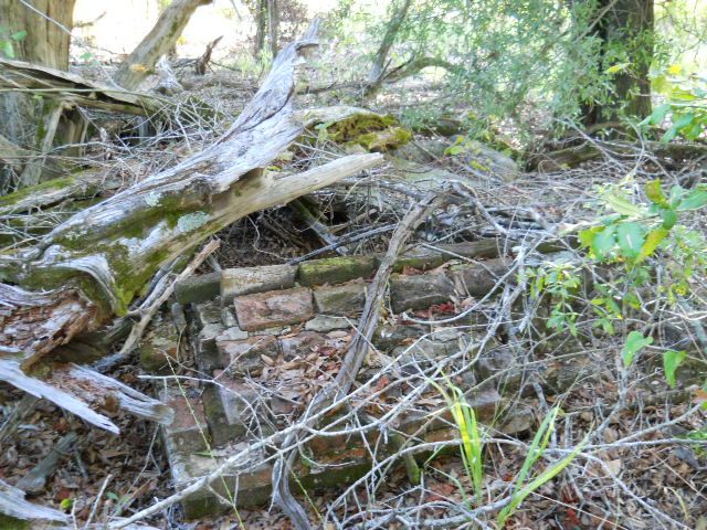
| Description | : | Small family cemetery located on private property about 5 miles north of Fort Gaines in Clay County GA, at/near the site of the old Crozier Plantation just off the Chattahoochee River. Burials consist of Dr B P Smith and his wife Sarah E Green Smith, along with at least two unidentified graves with primitive markers which are unnamed. In addition to these burials there are also old primitive cabin hearths on the property from the original settlers. The old plantation is either the same as or immediately next to the old Crozier plantation homestead in Clay County Ga. There is... Read More |
frequently asked questions (FAQ):
-
Where is Smith Greene Family Cemetery?
Smith Greene Family Cemetery is located at Fort Gaines, Clay County, USA.
-
Smith Greene Family Cemetery cemetery's updated grave count on graveviews.com?
0 memorials
Nearby Cemetories:
1. Bethel Church Cemetery #2
Clay County, USA
Coordinate: 31.6182995, -84.9428024
2. Bluffton Cemetery
Bluffton, Clay County, USA
Coordinate: 31.6035995, -84.9730988
3. Coates Cemetery
Bluffton, Clay County, USA
Coordinate: 31.6403008, -84.9882965
4. Elias Lee Family Cemetery
Bluffton, Clay County, USA
Coordinate: 31.5935993, -84.9313965
5. Friendship Baptist Church Cemetery
Bluffton, Clay County, USA
Coordinate: 31.7553730, -85.0485560
6. Todd Cemetery
Bluffton, Clay County, USA
Coordinate: 31.7786007, -85.1035995
7. Union AME Church Cemetery
Bluffton, Clay County, USA
Coordinate: 31.6583004, -84.9682999
8. Vincent Cemetery
Bluffton, Clay County, USA
Coordinate: 31.5192432, -84.8542328
9. Mount Zion Cemetery
Clay County, USA
Coordinate: 31.5293999, -84.9308014
10. New Lowell Cemetery
Clay County, USA
Coordinate: 31.6557999, -85.0242004
11. Shiloh Cemetery
Clay County, USA
12. Ebenezer AME Church Cemetery
Zetto, Clay County, USA
Coordinate: 31.6777992, -85.0083008
13. Judson Cemetery
Clay County, USA
Coordinate: 31.6182995, -84.9428024
14. Mount Vernon Cemetery
Clay County, USA
Coordinate: 31.6035995, -84.9730988
15. Pecan Cemetery
Clay County, USA
Coordinate: 31.6403008, -84.9882965
16. Wesley Cemetery
Clay County, USA
Coordinate: 31.5935993, -84.9313965
17. Mount Zion Church Cemetery #2
Days Crossroads, Clay County, USA
Coordinate: 31.7553730, -85.0485560
18. Saint James Cemetery
Clay County, USA
Coordinate: 31.7786007, -85.1035995
19. Singletary Cemetery
Clay County, USA
Coordinate: 31.6583004, -84.9682999
20. Blocker Family Cemetery
Clay County, USA
Coordinate: 31.5192432, -84.8542328
21. Bryant-Neves Cemetery
Clay County, USA
Coordinate: 31.5293999, -84.9308014
22. Campground Cemetery
Clay County, USA
Coordinate: 31.6557999, -85.0242004
23. Esau Davis Gravesite
Clay County, USA
24. Mount Gilead Cemetery
Clay County, USA
Coordinate: 31.6777992, -85.0083008