| Memorials | : | 0 |
| Location | : | Blunsdon St Andrew, Swindon Unitary Authority, England |
| Phone | : | 07588 594410 |
| Website | : | www.nschurch.org.uk/ |
| Coordinate | : | 51.6059595, -1.8048494 |
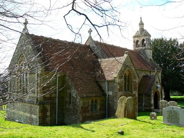
| Description | : | St Andrew's Church is Grade II Listed. Elements of the church appear to be 13th- century in origin, although it was almost entirely rebuilt in 1868. A settlement at Bluntesdone is recorded in the Domesday Survey of 1086 and the place name Bluntesdon Seynt Andreu is recorded in 1281.The village was probably originally centred on St Andrew's Church. Although a building known as Blunsdon Abbey previously lay to the south of the site, there is no evidence for any religious house in the area. The Church lies in a wider landscape of prehistoric and Romano-British rural settlement in north Wiltshire.... Read More |
frequently asked questions (FAQ):
-
Where is St Andrew's Church?
St Andrew's Church is located at St Andrew's Church, Tadpole Lane, Blunsdon, Swindon Blunsdon St Andrew, Swindon Unitary Authority ,Wiltshire , SN25 2DWEngland.
-
St Andrew's Church cemetery's updated grave count on graveviews.com?
0 memorials
-
Where are the coordinates of the St Andrew's Church?
Latitude: 51.6059595
Longitude: -1.8048494
Nearby Cemetories:
1. St. Leonard's Churchyard
Broad Blunsdon, Swindon Unitary Authority, England
Coordinate: 51.6153980, -1.7804317
2. Blunsdon Cemetery
Broad Blunsdon, Swindon Unitary Authority, England
Coordinate: 51.6160210, -1.7774919
3. Whitworth Road Cemetery
Swindon, Swindon Unitary Authority, England
Coordinate: 51.5836530, -1.7862070
4. St. Mary's Churchyard
Swindon, Swindon Unitary Authority, England
Coordinate: 51.5790500, -1.7990100
5. Upper Stratton Cemetery
Stratton St Margaret, Swindon Unitary Authority, England
Coordinate: 51.5833283, -1.7661632
6. Kingsdown Crematorium
Swindon, Swindon Unitary Authority, England
Coordinate: 51.5968450, -1.7513770
7. St Margaret Churchyard
Stratton St Margaret, Swindon Unitary Authority, England
Coordinate: 51.5824430, -1.7422550
8. St. Sampson Churchyard
Cricklade, Wiltshire Unitary Authority, England
Coordinate: 51.6405970, -1.8580760
9. St. Mary's Churchyard
Cricklade, Wiltshire Unitary Authority, England
Coordinate: 51.6435624, -1.8553451
10. Cricklade Cemetery
Cricklade, Wiltshire Unitary Authority, England
Coordinate: 51.6414360, -1.8605570
11. Radnor Street Cemetery
Swindon, Swindon Unitary Authority, England
Coordinate: 51.5556150, -1.7885900
12. Lydiard Tregoze St Mary Church
Blagrove, Swindon Unitary Authority, England
Coordinate: 51.5617700, -1.8514300
13. Saint Mary Magdalene Church Cemetery
South Marston, Swindon Unitary Authority, England
Coordinate: 51.5903900, -1.7195100
14. Christ Church Burial Ground
Swindon, Swindon Unitary Authority, England
Coordinate: 51.5537243, -1.7744208
15. Highworth Cemetery
Highworth, Swindon Unitary Authority, England
Coordinate: 51.6285450, -1.7212890
16. Parish Church of St. Mary
Castle Eaton, Swindon Unitary Authority, England
Coordinate: 51.6624180, -1.7896647
17. St. Mary's Churchyard
Kempsford, Cotswold District, England
Coordinate: 51.6670420, -1.7681363
18. St. James' Churchyard
Sevenhampton, Swindon Unitary Authority, England
Coordinate: 51.6119590, -1.6984440
19. All Saints Churchyard
Down Ampney, Cotswold District, England
Coordinate: 51.6674850, -1.8592640
20. St John Baptist and St Helen Churchyard
Wroughton, Swindon Unitary Authority, England
Coordinate: 51.5210500, -1.8030770
21. Saint Andrew's Church
Wanborough, Swindon Unitary Authority, England
Coordinate: 51.5415040, -1.7018220
22. St. James Churchyard
Bourton, Cherwell District, England
Coordinate: 51.5794090, -1.6638890
23. Holy Cross Churchyard
Ashton Keynes, Wiltshire Unitary Authority, England
Coordinate: 51.6479000, -1.9394000
24. St. Andrew's Churchyard
Shrivenham, Vale of White Horse District, England
Coordinate: 51.6000270, -1.6537370

