
| Memorials | : | 0 |
| Location | : | Corney, Copeland Borough, England |
| Coordinate | : | 54.3099720, -3.3656840 |
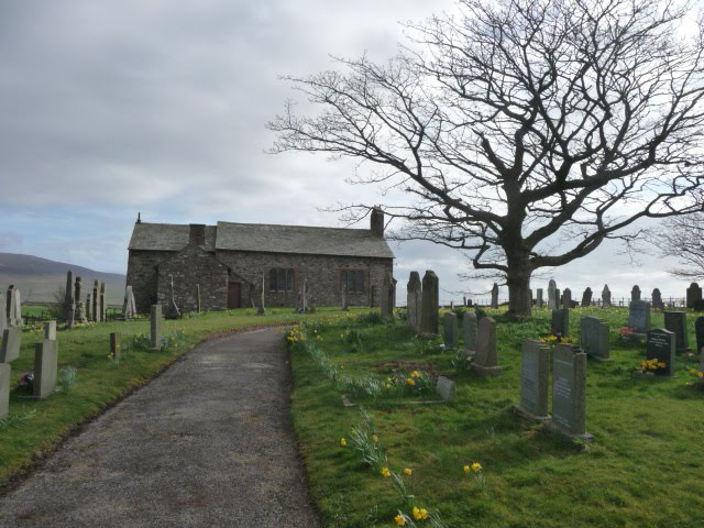
| Description | : | St. John the Baptist, Church Brow, Corney Fell, Bootle, Cumbria LA19 5TW A beautiful country church serving a small, mainly farming, community, Corney St John the Baptist is perched on a shelf of land between the coast and the higher fells. To the east is a fine view of Black Combe and the lakeland mountains, and to the west, the Irish Sea, with distant glimpses of Scotland and the Isle of Man. The unspoilt churchyard is notable for its rich flora. The small congregation prefers a traditional style of worship. Services are held every fortnight. ======================== There is one wargrave of the Great... Read More |
frequently asked questions (FAQ):
-
Where is St. John The Baptist Churchyard?
St. John The Baptist Churchyard is located at Church Brow, Corney Fell Corney, Copeland Borough ,Cumbria , LA19 5TXEngland.
-
St. John The Baptist Churchyard cemetery's updated grave count on graveviews.com?
0 memorials
-
Where are the coordinates of the St. John The Baptist Churchyard?
Latitude: 54.3099720
Longitude: -3.3656840
Nearby Cemetories:
1. St. Michael and All Angels Churchyard
Bootle, Copeland Borough, England
Coordinate: 54.2833510, -3.3732080
2. St John's Church
Waberthwaite, Copeland Borough, England
Coordinate: 54.3433418, -3.3854907
3. Saint Michael and All Angels
Muncaster, Copeland Borough, England
Coordinate: 54.3567850, -3.3802270
4. St Mary's Churchyard
Whitbeck, Copeland Borough, England
Coordinate: 54.2438000, -3.3533470
5. Ulpha Churchyard Extension
Ulpha, Copeland Borough, England
Coordinate: 54.3282170, -3.2350270
6. St. John the Baptist Churchyard
Ulpha, Copeland Borough, England
Coordinate: 54.3285020, -3.2349130
7. St Anne Churchyard Thwaites
Millom Without, Copeland Borough, England
Coordinate: 54.2584700, -3.2632200
8. St. Peter Churchyard
Drigg, Copeland Borough, England
Coordinate: 54.3796400, -3.4328800
9. St Mary Churchyard
Whicham, Copeland Borough, England
Coordinate: 54.2326310, -3.3287160
10. St Paul Churchyard
Irton, Copeland Borough, England
Coordinate: 54.3915480, -3.4006870
11. St. Mary Magdalene Parish Churchyard
Broughton-in-Furness, South Lakeland District, England
Coordinate: 54.2761400, -3.2152660
12. Saint Catherine's Churchyard
Eskdale, Copeland Borough, England
Coordinate: 54.3911910, -3.2706530
13. Holy Trinity Churchyard
Millom, Copeland Borough, England
Coordinate: 54.2206610, -3.2727780
14. Holy Trinity Church
Duddon, South Lakeland District, England
Coordinate: 54.3549054, -3.1877149
15. Millom Cemetery
Millom, Copeland Borough, England
Coordinate: 54.2088860, -3.2731320
16. Nether Wasdale Cemetery
Nether Wasdale, Copeland Borough, England
Coordinate: 54.4242140, -3.3463910
17. St Michael and All Angels Churchyard
Nether Wasdale, Copeland Borough, England
Coordinate: 54.4245000, -3.3508600
18. St George Churchyard
Millom, Copeland Borough, England
Coordinate: 54.2085440, -3.2718660
19. St Mary's Churchyard
Gosforth, Copeland Borough, England
Coordinate: 54.4192540, -3.4313680
20. St Lukes Churchyard
Haverigg, Copeland Borough, England
Coordinate: 54.1968680, -3.2925720
21. St John the Evangelist
Woodland, South Lakeland District, England
Coordinate: 54.2919829, -3.1579023
22. Wall End Church of Christ Cemetery
Kirkby in Furness, South Lakeland District, England
Coordinate: 54.2389300, -3.1753120
23. St Cuthbert's Churchyard
Kirkby Ireleth, South Lakeland District, England
Coordinate: 54.2298000, -3.1770820
24. Ponsonby Parish Churchyard
Ponsonby, Copeland Borough, England
Coordinate: 54.4367970, -3.4782480