
| Memorials | : | 6 |
| Location | : | Eskdale, Copeland Borough, England |
| Coordinate | : | 54.3911910, -3.2706530 |
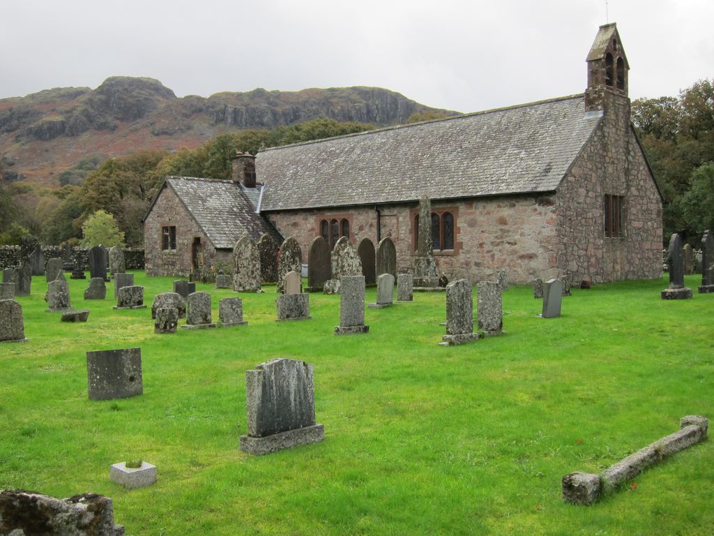
| Description | : | St Catherine's Church is the Parish Church of Eskdale. The Church lies beside the river Esk on which spot there has been a church since the 6th Century AD. The church guide states that little is known of the history of St Catherine's Church, Eskdale. Who built the chapel, and when, is unknown. There is, however, a strong tradition linking it with the loss of the White Ship in 1120, on St Catherine's Day. Amongst those lost was a nephew of Ranulph le Meschines: he was Richard Earl of Chester, and through him the Meschines family succeeded to the earldom.... Read More |
frequently asked questions (FAQ):
-
Where is Saint Catherine's Churchyard?
Saint Catherine's Churchyard is located at Boot Eskdale, Copeland Borough ,Cumbria , CA19 1TGEngland.
-
Saint Catherine's Churchyard cemetery's updated grave count on graveviews.com?
6 memorials
-
Where are the coordinates of the Saint Catherine's Churchyard?
Latitude: 54.3911910
Longitude: -3.2706530
Nearby Cemetories:
1. Nether Wasdale Cemetery
Nether Wasdale, Copeland Borough, England
Coordinate: 54.4242140, -3.3463910
2. St Michael and All Angels Churchyard
Nether Wasdale, Copeland Borough, England
Coordinate: 54.4245000, -3.3508600
3. Holy Trinity Church
Duddon, South Lakeland District, England
Coordinate: 54.3549054, -3.1877149
4. St. John the Baptist Churchyard
Ulpha, Copeland Borough, England
Coordinate: 54.3285020, -3.2349130
5. Ulpha Churchyard Extension
Ulpha, Copeland Borough, England
Coordinate: 54.3282170, -3.2350270
6. Saint Michael and All Angels
Muncaster, Copeland Borough, England
Coordinate: 54.3567850, -3.3802270
7. St Paul Churchyard
Irton, Copeland Borough, England
Coordinate: 54.3915480, -3.4006870
8. Saint Olaf's Churchyard
Wasdale, Copeland Borough, England
Coordinate: 54.4670350, -3.2535080
9. St John's Church
Waberthwaite, Copeland Borough, England
Coordinate: 54.3433418, -3.3854907
10. St. Peter Churchyard
Drigg, Copeland Borough, England
Coordinate: 54.3796400, -3.4328800
11. St Mary's Churchyard
Gosforth, Copeland Borough, England
Coordinate: 54.4192540, -3.4313680
12. St. John The Baptist Churchyard
Corney, Copeland Borough, England
Coordinate: 54.3099720, -3.3656840
13. Saint Luke Churchyard
Torver, South Lakeland District, England
Coordinate: 54.3390980, -3.1018010
14. Sacred Heart RC Churchyard
Coniston, South Lakeland District, England
Coordinate: 54.3610700, -3.0795620
15. St Andrew Churchyard
Coniston, South Lakeland District, England
Coordinate: 54.3688390, -3.0751230
16. Coniston Graveyard
Coniston, South Lakeland District, England
Coordinate: 54.3694000, -3.0731000
17. St John the Evangelist
Woodland, South Lakeland District, England
Coordinate: 54.2919829, -3.1579023
18. St. Mary Magdalene Parish Churchyard
Broughton-in-Furness, South Lakeland District, England
Coordinate: 54.2761400, -3.2152660
19. St. Michael and All Angels Churchyard
Bootle, Copeland Borough, England
Coordinate: 54.2833510, -3.3732080
20. Calder Abbey
Copeland Borough, England
Coordinate: 54.4441670, -3.4661110
21. Ponsonby Parish Churchyard
Ponsonby, Copeland Borough, England
Coordinate: 54.4367970, -3.4782480
22. St Anne Churchyard Thwaites
Millom Without, Copeland Borough, England
Coordinate: 54.2584700, -3.2632200
23. Langdale Cemetery
Chapel Stile, South Lakeland District, England
Coordinate: 54.4377600, -3.0500180
24. Holy Trinity Churchyard
Chapel Stile, South Lakeland District, England
Coordinate: 54.4402700, -3.0486090