
| Memorials | : | 1 |
| Location | : | Digswell, Welwyn Hatfield District, England |
| Coordinate | : | 51.8186190, -0.2051940 |
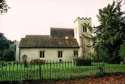
| Description | : | St. John's Church, Digswell, is nearly 800 years old. A church stood on the site at the time of the Norman conquest and today remains of the 12th century walls may still be seen enclosing the Lady Chapel. The church has been added to and enlarged across the centuries, particularly in the early 1960s when the church was considerably enlarged to accommodate the growth of Welwyn Garden City. Inside the church are several brasses which attract interest. In the best condition is that of Sir John Peryent and his Lady who died in 1432 and 1415 respectively. Sir... Read More |
frequently asked questions (FAQ):
-
Where is St John the Evangelist Churchyard?
St John the Evangelist Churchyard is located at Digswell, Welwyn Hatfield District ,Hertfordshire ,England.
-
St John the Evangelist Churchyard cemetery's updated grave count on graveviews.com?
1 memorials
-
Where are the coordinates of the St John the Evangelist Churchyard?
Latitude: 51.8186190
Longitude: -0.2051940
Nearby Cemetories:
1. St. Mary's Churchyard
Welwyn, Welwyn Hatfield District, England
Coordinate: 51.8311660, -0.2151400
2. Welwyn Cemetery
Welwyn, Welwyn Hatfield District, England
Coordinate: 51.8331340, -0.2199520
3. St Peter Churchyard
Ayot St Peter, Welwyn Hatfield District, England
Coordinate: 51.8201700, -0.2331800
4. St John the Evangelist Churchyard
Lemsford, Welwyn Hatfield District, England
Coordinate: 51.7934510, -0.2355890
5. Knebworth Cemetery
Knebworth, North Hertfordshire District, England
Coordinate: 51.8595280, -0.1867730
6. Ayot St Lawrence Old Churchyard
Ayot St Lawrence, Welwyn Hatfield District, England
Coordinate: 51.8377038, -0.2678795
7. St Lawrence Churchyard
Ayot St Lawrence, Welwyn Hatfield District, England
Coordinate: 51.8379490, -0.2717340
8. All Saints Churchyard
Datchworth, East Hertfordshire District, England
Coordinate: 51.8575577, -0.1609916
9. St Andrew Church
Bramfield, East Hertfordshire District, England
Coordinate: 51.8241000, -0.1266000
10. St Martin
Knebworth, North Hertfordshire District, England
Coordinate: 51.8654900, -0.1820500
11. St. Mary's Churchyard
Knebworth, North Hertfordshire District, England
Coordinate: 51.8723580, -0.2160890
12. St. Luke's Churchyard
Hatfield, Welwyn Hatfield District, England
Coordinate: 51.7643980, -0.2237710
13. St. Helen's Churchyard
Wheathampstead, St Albans District, England
Coordinate: 51.8124510, -0.2946400
14. St. Etheldreda Churchyard
Hatfield, Welwyn Hatfield District, England
Coordinate: 51.7614490, -0.2120150
15. Wheathampstead United Churchyard
Wheathampstead, St Albans District, England
Coordinate: 51.8108170, -0.2972210
16. Harwood Park Crematorium
Stevenage, Stevenage Borough, England
Coordinate: 51.8717680, -0.1698410
17. Hatfield Estate
Hatfield, Welwyn Hatfield District, England
Coordinate: 51.7606100, -0.2092010
18. St. Mary's Churchyard
Essendon, Welwyn Hatfield District, England
Coordinate: 51.7630460, -0.1561580
19. Ss Peter and Paul Churchyard
Kimpton, North Hertfordshire District, England
Coordinate: 51.8527990, -0.2918240
20. St Michael and All Angels Churchyard
Waterford, East Hertfordshire District, England
Coordinate: 51.8152260, -0.0971940
21. St Mary Churchyard
Hertingfordbury, East Hertfordshire District, England
Coordinate: 51.7919480, -0.1043700
22. Hertford Cemetery
Hertford, East Hertfordshire District, England
Coordinate: 51.8033280, -0.0979060
23. Ss Mary and Andrew Churchyard
Watton-at-Stone, East Hertfordshire District, England
Coordinate: 51.8533290, -0.1102500
24. St Mary the Virgin Churchyard
Stapleford, East Hertfordshire District, England
Coordinate: 51.8349710, -0.0973140