
| Memorials | : | 20 |
| Location | : | Essendon, Welwyn Hatfield District, England |
| Coordinate | : | 51.7630460, -0.1561580 |
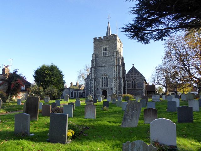
| Description | : | Essendon is a Hertfordshire village and civil parish located 6 miles south-west of the town of Hertford on the B158 road. The village is 100 metres above sea level and offers views of the Lea Valley to the north. Although on an ancient site, St Mary's Church dates mainly from the 17th and 18th centuries and was restored in 1883. The west tower dates from the 15th century and has six bells, the oldest is dated 1681. The church contains an unusual Wedgewood ceramic font dated 1780 and several brasses and monuments. In 1916 the east end of the church was... Read More |
frequently asked questions (FAQ):
-
Where is St. Mary's Churchyard?
St. Mary's Churchyard is located at Church Street Essendon, Welwyn Hatfield District ,Hertfordshire ,England.
-
St. Mary's Churchyard cemetery's updated grave count on graveviews.com?
20 memorials
-
Where are the coordinates of the St. Mary's Churchyard?
Latitude: 51.7630460
Longitude: -0.1561580
Nearby Cemetories:
1. St. Andrew's Churchyard
Little Berkhamsted, East Hertfordshire District, England
Coordinate: 51.7547390, -0.1295270
2. Saint Mary
Bayford, East Hertfordshire District, England
Coordinate: 51.7629540, -0.1035070
3. Hatfield Estate
Hatfield, Welwyn Hatfield District, England
Coordinate: 51.7606100, -0.2092010
4. St. Etheldreda Churchyard
Hatfield, Welwyn Hatfield District, England
Coordinate: 51.7614490, -0.2120150
5. St. Luke's Churchyard
Hatfield, Welwyn Hatfield District, England
Coordinate: 51.7643980, -0.2237710
6. St Mary Churchyard
Hertingfordbury, East Hertfordshire District, England
Coordinate: 51.7919480, -0.1043700
7. Welwyn Hatfield Lawn Cemetery
Welwyn Hatfield, Welwyn Hatfield District, England
Coordinate: 51.7422400, -0.2315670
8. Hertford Cemetery
Hertford, East Hertfordshire District, England
Coordinate: 51.8033280, -0.0979060
9. St Andrews Cemetery
Hertford, East Hertfordshire District, England
Coordinate: 51.8026720, -0.0951500
10. Saint Andrew Churchyard
Hertford, East Hertfordshire District, England
Coordinate: 51.7960550, -0.0823520
11. St John the Evangelist Churchyard
Lemsford, Welwyn Hatfield District, England
Coordinate: 51.7934510, -0.2355890
12. All Saints with Saint John Churchyard
Hertford, East Hertfordshire District, England
Coordinate: 51.7950040, -0.0757330
13. The Immaculate Conception and St Joseph
Hertford, East Hertfordshire District, England
Coordinate: 51.7988966, -0.0745293
14. St John the Evangelist Churchyard
Digswell, Welwyn Hatfield District, England
Coordinate: 51.8186190, -0.2051940
15. Holy Trinity Churchyard
Bengeo, East Hertfordshire District, England
Coordinate: 51.8053500, -0.0798610
16. St Michael and All Angels Churchyard
Waterford, East Hertfordshire District, England
Coordinate: 51.8152260, -0.0971940
17. St Andrew Church
Bramfield, East Hertfordshire District, England
Coordinate: 51.8241000, -0.1266000
18. St. Leonard's Churchyard
Bengeo, East Hertfordshire District, England
Coordinate: 51.8055165, -0.0722084
19. St. Mary's Churchyard
Potters Bar, Hertsmere Borough, England
Coordinate: 51.6926910, -0.1849770
20. Holy Trinity Churchyard
Hertford Heath, East Hertfordshire District, England
Coordinate: 51.7865300, -0.0433980
21. St Peter Churchyard
Ayot St Peter, Welwyn Hatfield District, England
Coordinate: 51.8201700, -0.2331800
22. St. Mary's Churchyard
Welwyn, Welwyn Hatfield District, England
Coordinate: 51.8311660, -0.2151400
23. St. Laurence Churchyard
Wormley, Broxbourne Borough, England
Coordinate: 51.7352050, -0.0389350
24. Adath Yisroel Cemetery
Cheshunt, Broxbourne Borough, England
Coordinate: 51.7015690, -0.0772910