
| Memorials | : | 0 |
| Location | : | Bodmin, Cornwall Unitary Authority, England |
| Website | : | bodmin.gov.uk/services/cemeteries/ |
| Coordinate | : | 50.4700220, -4.7345900 |
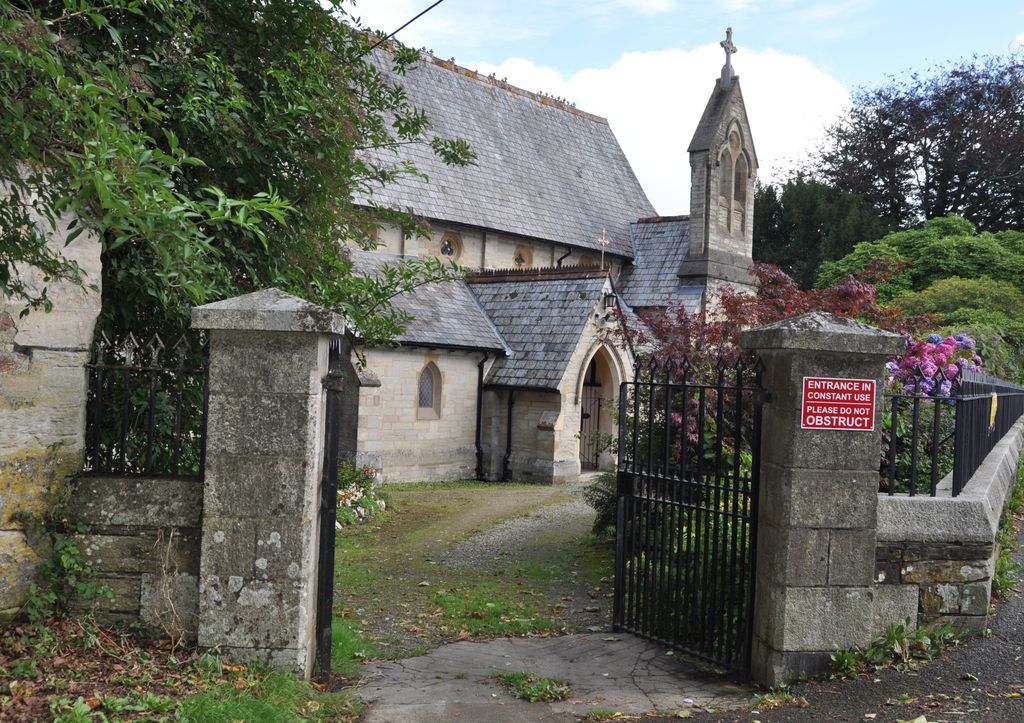
| Description | : | St Lawrence Church was previously the Chapel for the County Lunatic Asylum. It was built by public subscription and opened in 1861. It was extended in 1867 to accommodate extra staff and patients. The church was handed over to Bodmin Town Council when the NHS took over the Hospital. There were no burials in the Churchyard: It is referred to as a Garden of Remembrance with Cremation memorials only. |
frequently asked questions (FAQ):
-
Where is St Lawrence Community Churchyard?
St Lawrence Community Churchyard is located at West Heath Avenue Bodmin, Cornwall Unitary Authority ,Cornwall , PL31 2QTEngland.
-
St Lawrence Community Churchyard cemetery's updated grave count on graveviews.com?
0 memorials
-
Where are the coordinates of the St Lawrence Community Churchyard?
Latitude: 50.4700220
Longitude: -4.7345900
Nearby Cemetories:
1. Bodmin Jail
Bodmin, Cornwall Unitary Authority, England
Coordinate: 50.4749180, -4.7284800
2. Centenary Methodist Chapel
Bodmin, Cornwall Unitary Authority, England
Coordinate: 50.4708490, -4.7235180
3. Grey Friars
Bodmin, Cornwall Unitary Authority, England
Coordinate: 50.4705630, -4.7190570
4. Bodmin New Cemetery
Bodmin, Cornwall Unitary Authority, England
Coordinate: 50.4761490, -4.7194810
5. St Petroc Churchyard
Bodmin, Cornwall Unitary Authority, England
Coordinate: 50.4713620, -4.7167860
6. St Michael's Churchyard
Landrake, Cornwall Unitary Authority, England
Coordinate: 50.4747593, -4.7171859
7. Bodmin Old Cemetery
Bodmin, Cornwall Unitary Authority, England
Coordinate: 50.4757460, -4.7177320
8. Bodmin, Dissenters
Cornwall Unitary Authority, England
Coordinate: 50.4757031, -4.7170733
9. Glynn Valley Crematorium
Bodmin, Cornwall Unitary Authority, England
Coordinate: 50.4589010, -4.6874190
10. St Conan Churchyard
Egloshayle, Cornwall Unitary Authority, England
Coordinate: 50.4970780, -4.7714730
11. St Hydroc Churchyard
Lanhydrock, Cornwall Unitary Authority, England
Coordinate: 50.4411580, -4.6981200
12. St. Helena Churchyard
Helland, Cornwall Unitary Authority, England
Coordinate: 50.5100000, -4.7200000
13. Gunwen Methodist Chapel
Bodmin, Cornwall Unitary Authority, England
Coordinate: 50.4186600, -4.7427070
14. St. Meubred Churchyard
Cardinham, Cornwall Unitary Authority, England
Coordinate: 50.4879010, -4.6474830
15. St. Protus & St. Hyacinth Churchyard
Blisland, Cornwall Unitary Authority, England
Coordinate: 50.5272500, -4.6811400
16. Egloshayle Churchyard
Egloshayle, Cornwall Unitary Authority, England
Coordinate: 50.5125936, -4.8208436
17. Lanivet Churchyard
Lanivet, Cornwall Unitary Authority, England
Coordinate: 50.4000600, -4.7038300
18. Restormel Road Cemetery
Lostwithiel, Cornwall Unitary Authority, England
Coordinate: 50.4100830, -4.6693240
19. Lanlivery Churchyard
Lanlivery, Cornwall Unitary Authority, England
Coordinate: 50.3998158, -4.7030720
20. St. Bartholomew Church Cemetery
Lostwithiel, Cornwall Unitary Authority, England
Coordinate: 50.4073690, -4.6691250
21. Lostwithiel Borough Cemetery
Lostwithiel, Cornwall Unitary Authority, England
Coordinate: 50.4028000, -4.6754800
22. Cowbridge Cemetery
Lostwithiel, Cornwall Unitary Authority, England
Coordinate: 50.4022400, -4.6732450
23. St Cyriacus and St Julitta Church Cemetery
Luxulyan, Cornwall Unitary Authority, England
Coordinate: 50.3900250, -4.7415450
24. Boconnoc Parish Church
Boconnoc, Cornwall Unitary Authority, England
Coordinate: 50.4159600, -4.6094600