
| Memorials | : | 1 |
| Location | : | Ellel, City of Lancaster, England |
| Coordinate | : | 53.9756944, -2.7918522 |
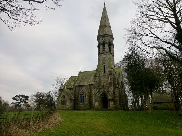
| Description | : | St. Mary's Chapel, Ellel Grange, was built by Alderman Preston and consecrated in 1873. The Chapel is unused and in a state of disrepair. The site lies to the south of Ellel Grange on the edge of a well wooded knoll. It is completely screened from all sides by mature woodland with access to the site being via a long single track access road on the western side of the A6. The site itself contains the existing Chapel building (formerly known as the Church of St. Mary and now known as Kings Lee Chapel) and the detached small Mausoleum building. |
frequently asked questions (FAQ):
-
Where is St. Mary's Chapel Ellel Grange?
St. Mary's Chapel Ellel Grange is located at Bay Horse Ellel, City of Lancaster ,Lancashire , LA2 0HNEngland.
-
St. Mary's Chapel Ellel Grange cemetery's updated grave count on graveviews.com?
1 memorials
-
Where are the coordinates of the St. Mary's Chapel Ellel Grange?
Latitude: 53.9756944
Longitude: -2.7918522
Nearby Cemetories:
1. St Thomas with Elizabeth Churchyard
Thurnham, City of Lancaster, England
Coordinate: 53.9819990, -2.8159520
2. Forton United Reform Church Cemetery
Forton, Wyre Borough, England
Coordinate: 53.9547940, -2.7813920
3. Saint Michael's and All Angels Church Cemetery
Cockerham, City of Lancaster, England
Coordinate: 53.9602092, -2.8204877
4. St John’s Church Graveyard
Ellel, City of Lancaster, England
Coordinate: 53.9990010, -2.7846660
5. St Paul's Churchyard
Forton, Wyre Borough, England
Coordinate: 53.9543760, -2.7605890
6. St Mark Churchyard
Dolphinholme, City of Lancaster, England
Coordinate: 53.9738730, -2.7378420
7. Christ Church of Glasson Churchyard
Glasson, City of Lancaster, England
Coordinate: 53.9966870, -2.8421460
8. St. Peter's Churchyard
Garstang, Wyre Borough, England
Coordinate: 53.9309510, -2.7591190
9. St. Helen's Churchyard
Overton, City of Lancaster, England
Coordinate: 54.0111620, -2.8552950
10. Scotforth Cemetery
Scotforth, City of Lancaster, England
Coordinate: 54.0282250, -2.8007170
11. Quernmore Methodist Churchyard
Quernmore, City of Lancaster, England
Coordinate: 54.0259440, -2.7361400
12. Quaker Burial Ground
Abbeystead, City of Lancaster, England
Coordinate: 53.9910820, -2.6912370
13. Christ Church Churchyard
Over Wyresdale, City of Lancaster, England
Coordinate: 53.9839250, -2.6861150
14. St Peter's Churchyard
Quernmore, City of Lancaster, England
Coordinate: 54.0367200, -2.7375400
15. Mount Street Congregational Chapel
Lancaster, City of Lancaster, England
Coordinate: 54.0468260, -2.8027430
16. Cathedral Cemetery of Lancaster
Lancaster, City of Lancaster, England
Coordinate: 54.0471170, -2.7942920
17. Friends Meeting House Burial Ground
Lancaster, City of Lancaster, England
Coordinate: 54.0482500, -2.8058025
18. St. Nicholas Street Chapel Churchyard
Lancaster, City of Lancaster, England
Coordinate: 54.0486900, -2.7987900
19. All Saints Parish Churchyard
Barnacre with Bonds, Wyre Borough, England
Coordinate: 53.9079120, -2.7430580
20. Garstang United Reformed Churchyard
Garstang, Wyre Borough, England
Coordinate: 53.9026500, -2.7747400
21. Lancaster Castle Cemetery
Lancaster, City of Lancaster, England
Coordinate: 54.0494330, -2.8047890
22. St. John the Evangelist Churchyard
Lancaster, City of Lancaster, England
Coordinate: 54.0504000, -2.7990000
23. Lancaster Cemetery
Lancaster, City of Lancaster, England
Coordinate: 54.0504210, -2.7768760
24. Lancaster Priory
Lancaster, City of Lancaster, England
Coordinate: 54.0507360, -2.8057850