
| Memorials | : | 0 |
| Location | : | Hardmead, Milton Keynes Borough, England |
| Coordinate | : | 52.1196000, -0.6358000 |
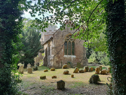
| Description | : | The west tower of the church dates from the 13th century, the chancel from slightly later, and the clerestory and the top stage of the tower were added in the 15th century. It formerly served a medieval village, but this has disappeared. After the church became redundant it was proposed to convert it into a house, but it was acquired by the charity the Friends of Friendless Churches and is now managed by the Friends of Hardmead.[2] The church was vested in the charity in 1982, which holds a 99-year lease with effect from 7 September 1982.[3] |
frequently asked questions (FAQ):
-
Where is St. Mary's Churchyard?
St. Mary's Churchyard is located at Hardmead, Milton Keynes Borough ,Buckinghamshire ,England.
-
St. Mary's Churchyard cemetery's updated grave count on graveviews.com?
0 memorials
-
Where are the coordinates of the St. Mary's Churchyard?
Latitude: 52.1196000
Longitude: -0.6358000
Nearby Cemetories:
1. St. Peter's Churchyard
Astwood, Milton Keynes Borough, England
Coordinate: 52.1164390, -0.6135200
2. St. Firmin Churchyard
North Crawley, Milton Keynes Borough, England
Coordinate: 52.0924400, -0.6485000
3. St Lawrence Churchyard
Chicheley, Milton Keynes Borough, England
Coordinate: 52.1037000, -0.6807000
4. St. Nicholas Churchyard
Newton Blossomville, Milton Keynes Borough, England
Coordinate: 52.1546343, -0.6482556
5. St Lauds Churchyard
Sherington, Milton Keynes Borough, England
Coordinate: 52.1122500, -0.7018140
6. St. Mary's Churchyard
Cold Brayfield, Milton Keynes Borough, England
Coordinate: 52.1609580, -0.6414440
7. St Mary's Churchyard
Clifton Reynes, Milton Keynes Borough, England
Coordinate: 52.1520000, -0.6820000
8. Cranfield Friend's Burial Ground
Cranfield, Central Bedfordshire Unitary Authority, England
Coordinate: 52.0820192, -0.5998549
9. All Saints Churchyard
Turvey, Bedford Borough, England
Coordinate: 52.1632000, -0.6267000
10. St. Leonard's Churchyard
Stagsden, Bedford Borough, England
Coordinate: 52.1313467, -0.5662217
11. Turvey Cemetery
Turvey, Bedford Borough, England
Coordinate: 52.1665007, -0.6243628
12. All Saints Churchyard
Emberton, Milton Keynes Borough, England
Coordinate: 52.1365770, -0.7082700
13. Olney Cemetery
Olney, Milton Keynes Borough, England
Coordinate: 52.1505480, -0.6996760
14. St Peter and St Paul Churchyard
Olney, Milton Keynes Borough, England
Coordinate: 52.1498710, -0.7009460
15. Mount Zion Burial Ground
Cranfield, Central Bedfordshire Unitary Authority, England
Coordinate: 52.0703595, -0.6110791
16. Olney Baptist Church Cemetery
Olney, Milton Keynes Borough, England
Coordinate: 52.1532830, -0.7021010
17. St Peter and St Paul Churchyard
Cranfield, Central Bedfordshire Unitary Authority, England
Coordinate: 52.0679750, -0.6071570
18. Cranfield Cemetery
Cranfield, Central Bedfordshire Unitary Authority, England
Coordinate: 52.0683000, -0.6041200
19. St. Michael's Churchyard
Lavendon, Milton Keynes Borough, England
Coordinate: 52.1734100, -0.6615200
20. Assumption of the Blessed Virgin Mary Churchyard
Moulsoe, Milton Keynes Borough, England
Coordinate: 52.0666500, -0.6790070
21. Lathbury Churchyard
Lathbury, Milton Keynes Borough, England
Coordinate: 52.0963900, -0.7247400
22. Newport Pagnell Old Cemetery
Newport Pagnell, Milton Keynes Borough, England
Coordinate: 52.0873930, -0.7186730
23. Tickford Street Cemetery
Newport Pagnell, Milton Keynes Borough, England
Coordinate: 52.0807670, -0.7121200
24. St. Peter and St. Paul's Churchyard
Newport Pagnell, Milton Keynes Borough, England
Coordinate: 52.0869970, -0.7203080