| Memorials | : | 0 |
| Location | : | Cranfield, Central Bedfordshire Unitary Authority, England |
| Coordinate | : | 52.0820192, -0.5998549 |
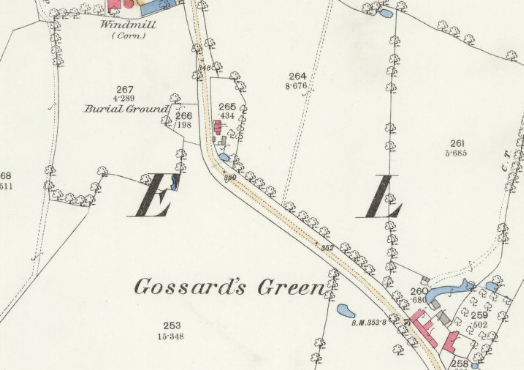
| Description | : | In April 1690 Cranfield registered a Meetinghouse at Gossards Green. This stood at the north western end of Gossards Green adjoining Meeting House Close. It was closed in 1849 and demolished in 1866 after being used as a cottage. A burial ground, in which about 17 adults and several children are buried, adjoins the site of the meeting house. The last burial was in c.1860. (Quakers in Cranfield by Sally Williams) |
frequently asked questions (FAQ):
-
Where is Cranfield Friend's Burial Ground?
Cranfield Friend's Burial Ground is located at Bourne End Road, Cranfield, Central Bedfordshire Unitary Authority, Bedfordshire, England Cranfield, Central Bedfordshire Unitary Authority ,Bedfordshire ,England.
-
Cranfield Friend's Burial Ground cemetery's updated grave count on graveviews.com?
0 memorials
-
Where are the coordinates of the Cranfield Friend's Burial Ground?
Latitude: 52.0820192
Longitude: -0.5998549
Nearby Cemetories:
1. Mount Zion Burial Ground
Cranfield, Central Bedfordshire Unitary Authority, England
Coordinate: 52.0703595, -0.6110791
2. Cranfield Cemetery
Cranfield, Central Bedfordshire Unitary Authority, England
Coordinate: 52.0683000, -0.6041200
3. St Peter and St Paul Churchyard
Cranfield, Central Bedfordshire Unitary Authority, England
Coordinate: 52.0679750, -0.6071570
4. St. Firmin Churchyard
North Crawley, Milton Keynes Borough, England
Coordinate: 52.0924400, -0.6485000
5. St. Peter's Churchyard
Astwood, Milton Keynes Borough, England
Coordinate: 52.1164390, -0.6135200
6. St Mary the Virgin Churchyard
Marston Moretaine, Central Bedfordshire Unitary Authority, England
Coordinate: 52.0597750, -0.5484290
7. St Mary the Virgin Churchyard
Wootton, Bedford Borough, England
Coordinate: 52.0948730, -0.5362630
8. Wootton (Lorraine Road) Cemetery
Wootton, Bedford Borough, England
Coordinate: 52.0987769, -0.5351370
9. St. Mary's Churchyard
Hardmead, Milton Keynes Borough, England
Coordinate: 52.1196000, -0.6358000
10. St Nicholas Churchyard
Hulcote, Central Bedfordshire Unitary Authority, England
Coordinate: 52.0399000, -0.6246000
11. St. Mary the Virgin Churchyard
Salford, Central Bedfordshire Unitary Authority, England
Coordinate: 52.0424070, -0.6368910
12. Assumption of the Blessed Virgin Mary Churchyard
Moulsoe, Milton Keynes Borough, England
Coordinate: 52.0666500, -0.6790070
13. St. Leonard's Churchyard
Stagsden, Bedford Borough, England
Coordinate: 52.1313467, -0.5662217
14. St Lawrence Churchyard
Chicheley, Milton Keynes Borough, England
Coordinate: 52.1037000, -0.6807000
15. Kempston Cemetery
Kempston, Bedford Borough, England
Coordinate: 52.1182990, -0.5224960
16. All Saints Churchyard
Kempston, Bedford Borough, England
Coordinate: 52.1209010, -0.5185350
17. St. Michael and All Angels Churchyard
Millbrook, Central Bedfordshire Unitary Authority, England
Coordinate: 52.0358350, -0.5231810
18. St James Churchyard
Husborne Crawley, Central Bedfordshire Unitary Authority, England
Coordinate: 52.0162250, -0.6090110
19. St. Lawrence's Churchyard
Broughton, Milton Keynes Borough, England
Coordinate: 52.0522000, -0.6980000
20. St. Botolph's Churchyard
Aspley Guise, Central Bedfordshire Unitary Authority, England
Coordinate: 52.0166510, -0.6281470
21. Tickford Street Cemetery
Newport Pagnell, Milton Keynes Borough, England
Coordinate: 52.0807670, -0.7121200
22. St Lauds Churchyard
Sherington, Milton Keynes Borough, England
Coordinate: 52.1122500, -0.7018140
23. St. Mary's Churchyard
Wavendon, Milton Keynes Borough, England
Coordinate: 52.0257000, -0.6730000
24. All Saint's Churchyard
Ridgmont, Central Bedfordshire Unitary Authority, England
Coordinate: 52.0117910, -0.5719780

