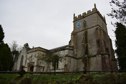
| Memorials | : | 0 |
| Location | : | Ashbury, Vale of White Horse District, England |
| Coordinate | : | 51.5626390, -1.6183810 |
| Description | : | The church, and town, was part of Berkshire until the 1974 boundary changes transferred it to Oxfordshire. The Church of England parish church of Saint Mary was originally Norman, rebuilt in the 13th century and in the 20th century, artist Martin Travers converted the north transept into a chapel of Saint Hubert in memory of Evelyn, Countess Craven who had lived at Ashdown House in the parish. |
frequently asked questions (FAQ):
-
Where is St Mary the Virgin Church?
St Mary the Virgin Church is located at Church Lane Ashbury, Vale of White Horse District ,Oxfordshire ,England.
-
St Mary the Virgin Church cemetery's updated grave count on graveviews.com?
0 memorials
-
Where are the coordinates of the St Mary the Virgin Church?
Latitude: 51.5626390
Longitude: -1.6183810
Nearby Cemetories:
1. St. Mary the Virgin Churchyard
Bishopstone, Swindon Unitary Authority, England
Coordinate: 51.5519060, -1.6499760
2. St Swithun
Compton Beauchamp, Vale of White Horse District, England
Coordinate: 51.5814163, -1.5981875
3. St. James Churchyard
Bourton, Cherwell District, England
Coordinate: 51.5794090, -1.6638890
4. St Swithun Churchyard Hinton Prava
Swindon Unitary Authority, England
Coordinate: 51.5481447, -1.6669194
5. St Swithun Churchyard Hinton Prava
Swindon Unitary Authority, England
Coordinate: 51.5481447, -1.6669194
6. All Saints
Woolstone, Vale of White Horse District, England
Coordinate: 51.5870310, -1.5765330
7. Shrivenham Parish Cemetery
Shrivenham, Vale of White Horse District, England
Coordinate: 51.5942061, -1.6517227
8. St. Andrew's Churchyard
Shrivenham, Vale of White Horse District, England
Coordinate: 51.6000270, -1.6537370
9. St. Thomas Churchyard
Watchfield, Vale of White Horse District, England
Coordinate: 51.6107409, -1.6468265
10. St Mary Churchyard
Uffington, Vale of White Horse District, England
Coordinate: 51.6018480, -1.5649000
11. Watchfield Cemetery
Watchfield, Vale of White Horse District, England
Coordinate: 51.6109220, -1.6467980
12. Watchfield Military Cemetery
Watchfield, Vale of White Horse District, England
Coordinate: 51.6110800, -1.6469400
13. St Mary the Virgin Parish Churchyard
Longcot, Vale of White Horse District, England
Coordinate: 51.6146420, -1.6056320
14. Saint Andrew's Church
Wanborough, Swindon Unitary Authority, England
Coordinate: 51.5415040, -1.7018220
15. Upper Lambourn Cemetery
Upper Lambourn, West Berkshire Unitary Authority, England
Coordinate: 51.5206400, -1.5499370
16. St. Luke's Churchyard
West Berkshire Unitary Authority, England
Coordinate: 51.5209870, -1.5492870
17. All Saints Churchyard
Liddington, Swindon Unitary Authority, England
Coordinate: 51.5298160, -1.7038690
18. St Nicholas Church
Baydon, Wiltshire Unitary Authority, England
Coordinate: 51.5008798, -1.5961523
19. Kingston Lisle Cemetery
Kingston Lisle, Vale of White Horse District, England
Coordinate: 51.5931324, -1.5284142
20. St John the Evangelist Churchyard
Fernham, Vale of White Horse District, England
Coordinate: 51.6251600, -1.5777100
21. Saint Mary Magdalene Church Cemetery
South Marston, Swindon Unitary Authority, England
Coordinate: 51.5903900, -1.7195100
22. St Nicholas Churchyard
Baulking, Vale of White Horse District, England
Coordinate: 51.6142910, -1.5431850
23. St. James' Churchyard
Sevenhampton, Swindon Unitary Authority, England
Coordinate: 51.6119590, -1.6984440
24. St Michael and All Angels Churchyard
Lambourn, West Berkshire Unitary Authority, England
Coordinate: 51.5086000, -1.5316000

