| Memorials | : | 0 |
| Location | : | Swindon Unitary Authority, England |
| Phone | : | https://www.achurchn |
| Website | : | www.achurchnearyou.com/church/11844/find-us/ |
| Coordinate | : | 51.5481447, -1.6669194 |
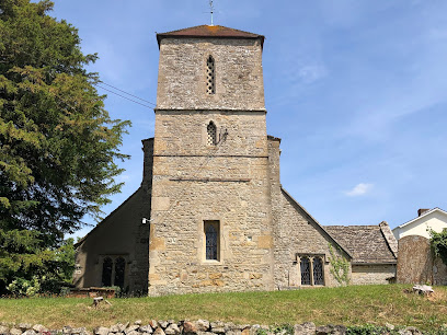
| Description | : | Hinton Parva, also known as Little Hinton, is a village in the Borough of Swindon in Wiltshire, England. It lies about 2 miles (3.2 km) from the eastern edge of the Swindon built-up area, and is separated from the town by farmland and the village of Wanborough. Hinton Parva was a separate civil parish parish until 1934, and is now in the parish of Bishopstone. Parts of the village were taken over by the War Department during World War II in 1943 to store tanks. The Norman parish church of St Swithun is a Grade I listed building. An area around the... Read More |
frequently asked questions (FAQ):
-
Where is St Swithun Churchyard Hinton Prava?
St Swithun Churchyard Hinton Prava is located at 2 Church Row Swindon Unitary Authority ,Wiltshire , SN4 0DLEngland.
-
St Swithun Churchyard Hinton Prava cemetery's updated grave count on graveviews.com?
0 memorials
-
Where are the coordinates of the St Swithun Churchyard Hinton Prava?
Latitude: 51.5481447
Longitude: -1.6669194
Nearby Cemetories:
1. St. Mary the Virgin Churchyard
Bishopstone, Swindon Unitary Authority, England
Coordinate: 51.5519060, -1.6499760
2. Saint Andrew's Church
Wanborough, Swindon Unitary Authority, England
Coordinate: 51.5415040, -1.7018220
3. All Saints Churchyard
Liddington, Swindon Unitary Authority, England
Coordinate: 51.5298160, -1.7038690
4. St. James Churchyard
Bourton, Cherwell District, England
Coordinate: 51.5794090, -1.6638890
5. St Mary the Virgin Church
Ashbury, Vale of White Horse District, England
Coordinate: 51.5626390, -1.6183810
6. Shrivenham Parish Cemetery
Shrivenham, Vale of White Horse District, England
Coordinate: 51.5942061, -1.6517227
7. St. Andrew's Churchyard
Shrivenham, Vale of White Horse District, England
Coordinate: 51.6000270, -1.6537370
8. Saint Mary Magdalene Church Cemetery
South Marston, Swindon Unitary Authority, England
Coordinate: 51.5903900, -1.7195100
9. St Swithun
Compton Beauchamp, Vale of White Horse District, England
Coordinate: 51.5814163, -1.5981875
10. St Margaret Churchyard
Stratton St Margaret, Swindon Unitary Authority, England
Coordinate: 51.5824430, -1.7422550
11. St. Thomas Churchyard
Watchfield, Vale of White Horse District, England
Coordinate: 51.6107409, -1.6468265
12. Watchfield Cemetery
Watchfield, Vale of White Horse District, England
Coordinate: 51.6109220, -1.6467980
13. Watchfield Military Cemetery
Watchfield, Vale of White Horse District, England
Coordinate: 51.6110800, -1.6469400
14. St Nicholas Church
Baydon, Wiltshire Unitary Authority, England
Coordinate: 51.5008798, -1.5961523
15. St. James' Churchyard
Sevenhampton, Swindon Unitary Authority, England
Coordinate: 51.6119590, -1.6984440
16. Christ Church Burial Ground
Swindon, Swindon Unitary Authority, England
Coordinate: 51.5537243, -1.7744208
17. Draycot Churchyard
Chiseldon, Swindon Unitary Authority, England
Coordinate: 51.4977100, -1.7399170
18. All Saints
Woolstone, Vale of White Horse District, England
Coordinate: 51.5870310, -1.5765330
19. St Michael Churchyard
Aldbourne, Wiltshire Unitary Authority, England
Coordinate: 51.4835694, -1.6209028
20. Upper Stratton Cemetery
Stratton St Margaret, Swindon Unitary Authority, England
Coordinate: 51.5833283, -1.7661632
21. Kingsdown Crematorium
Swindon, Swindon Unitary Authority, England
Coordinate: 51.5968450, -1.7513770
22. Radnor Street Cemetery
Swindon, Swindon Unitary Authority, England
Coordinate: 51.5556150, -1.7885900
23. St Mary the Virgin Parish Churchyard
Longcot, Vale of White Horse District, England
Coordinate: 51.6146420, -1.6056320
24. Upper Lambourn Cemetery
Upper Lambourn, West Berkshire Unitary Authority, England
Coordinate: 51.5206400, -1.5499370

