
| Memorials | : | 1 |
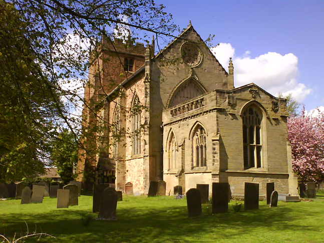
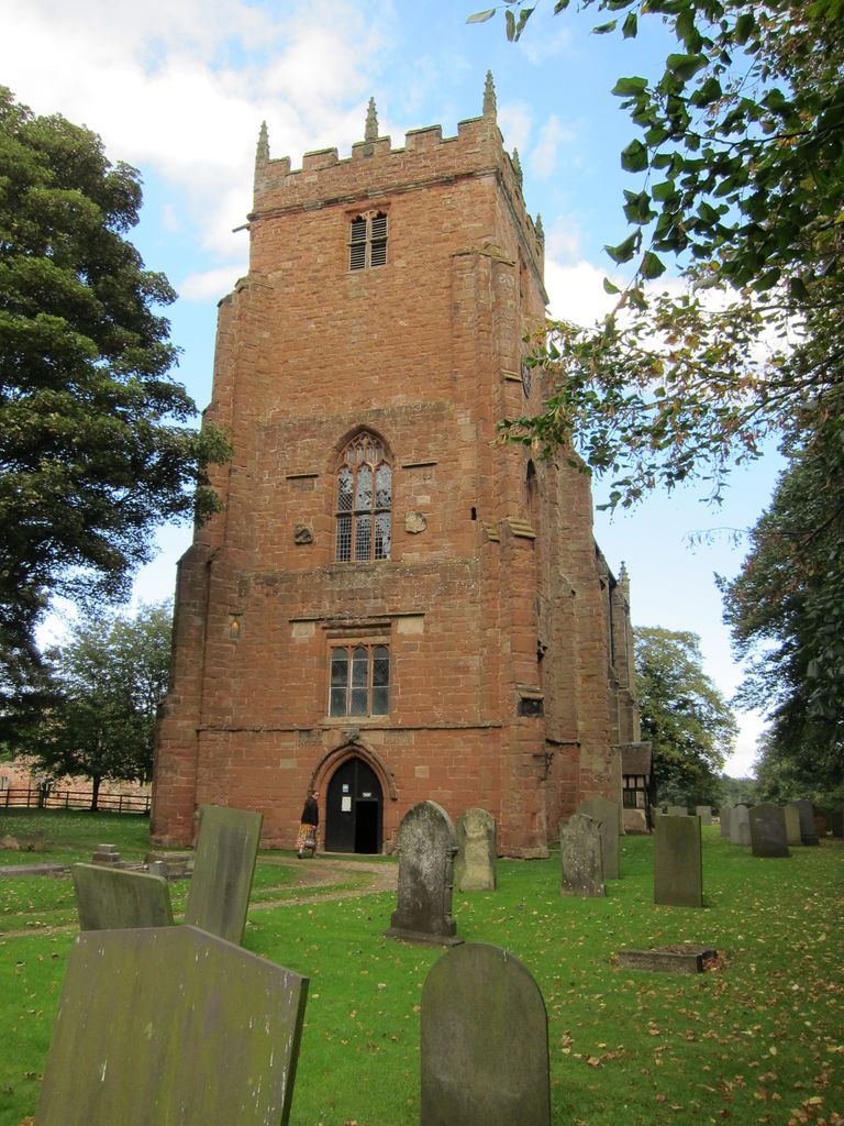
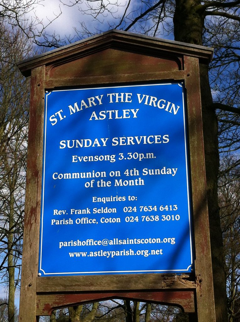
| Location | : | Astley, North Warwickshire Borough, England |
| Coordinate | : | 52.5019060, -1.5432740 |
| Description | : | The parish church was rebuilt by Sir Thomas Astley in 1343. A Saxon carving of a sundial from an earlier church was preserved in the tower. Thomas Grey, 2nd Marquess of Dorset was entombed in the church in 1530. The present church dates from another rebuild in 1617 by the Chamberlayne family. It is mainly the chancel of the 1343 building and the original east window incorporated into the tower. Preserved in the church are effigies of the Grey family, eighteen choir stalls painted with images of the prophets and apostles and, on the ceiling, 21 heraldic shields of Midlands... Read More |
frequently asked questions (FAQ):
-
Where is St. Mary the Virgin Churchyard?
St. Mary the Virgin Churchyard is located at Nuthurst Lane Astley, North Warwickshire Borough ,Warwickshire , CV10 7QNEngland.
-
St. Mary the Virgin Churchyard cemetery's updated grave count on graveviews.com?
1 memorials
-
Where are the coordinates of the St. Mary the Virgin Churchyard?
Latitude: 52.5019060
Longitude: -1.5432740
Nearby Cemetories:
1. St. Michaels Parish Church
Arley, North Warwickshire Borough, England
Coordinate: 52.5038140, -1.5703530
2. St Michael's Church
Coventry, Metropolitan Borough of Coventry, England
Coordinate: 52.5036300, -1.5707400
3. St Josephs Roman Catholic Church
Arley, North Warwickshire Borough, England
Coordinate: 52.5013130, -1.5769780
4. Erdbury Priory
Arbury, Nuneaton and Bedworth Borough, England
Coordinate: 52.5002190, -1.5074930
5. St Paul's Churchyard
Stockingford, Nuneaton and Bedworth Borough, England
Coordinate: 52.5191000, -1.5100000
6. St Wilfreds Parish Churchyard
Arley, North Warwickshire Borough, England
Coordinate: 52.5125900, -1.5846500
7. Bucks Hill Cemetery
Stockingford, Nuneaton and Bedworth Borough, England
Coordinate: 52.5317650, -1.5175750
8. St Mary & All Saints Churchyard
Fillongley, North Warwickshire Borough, England
Coordinate: 52.4817860, -1.5878250
9. St Laurence Churchyard
Ansley, North Warwickshire Borough, England
Coordinate: 52.5308620, -1.5737380
10. Congregational Church Burial Ground
Hartshill, North Warwickshire Borough, England
Coordinate: 52.5375900, -1.5227530
11. Corley Parish Churchyard
Corley, North Warwickshire Borough, England
Coordinate: 52.4632100, -1.5577050
12. Hartshill Cemetery
Hartshill, North Warwickshire Borough, England
Coordinate: 52.5440860, -1.5225490
13. Abbey Church
Nuneaton, Nuneaton and Bedworth Borough, England
Coordinate: 52.5256800, -1.4770800
14. St Giles Churchyard
Exhall, Nuneaton and Bedworth Borough, England
Coordinate: 52.4623930, -1.5003010
15. Marston Lane Cemetery
Bedworth, Nuneaton and Bedworth Borough, England
Coordinate: 52.4883470, -1.4678740
16. Friends Meeting House
Hartshill, North Warwickshire Borough, England
Coordinate: 52.5479560, -1.5204940
17. Old Meeting House URC Burial Ground
Bedworth, Nuneaton and Bedworth Borough, England
Coordinate: 52.4815660, -1.4714170
18. All Saints Churchyard
Chilvers Coton, Nuneaton and Bedworth Borough, England
Coordinate: 52.5133100, -1.4659600
19. All Saints Churchyard
Bedworth, Nuneaton and Bedworth Borough, England
Coordinate: 52.4790300, -1.4724590
20. Coventry Road Cemetery
Bedworth, Nuneaton and Bedworth Borough, England
Coordinate: 52.4775590, -1.4734910
21. Our Lady of the Angels Catholic Church
Nuneaton, Nuneaton and Bedworth Borough, England
Coordinate: 52.5174450, -1.4667010
22. St. Leonard Churchyard
Over Whitacre, North Warwickshire Borough, England
Coordinate: 52.5163500, -1.6266000
23. St Nicolas Churchyard
Nuneaton, Nuneaton and Bedworth Borough, England
Coordinate: 52.5214150, -1.4626130
24. Holy Trinity Churchyard
Attleborough, Nuneaton and Bedworth Borough, England
Coordinate: 52.5144020, -1.4563310