
| Memorials | : | 0 |
| Location | : | Sutton, Peterborough Unitary Authority, England |
| Website | : | www.castorchurch.co.uk/st-michael-angels-sutton/ |
| Coordinate | : | 52.5754356, -0.3853515 |
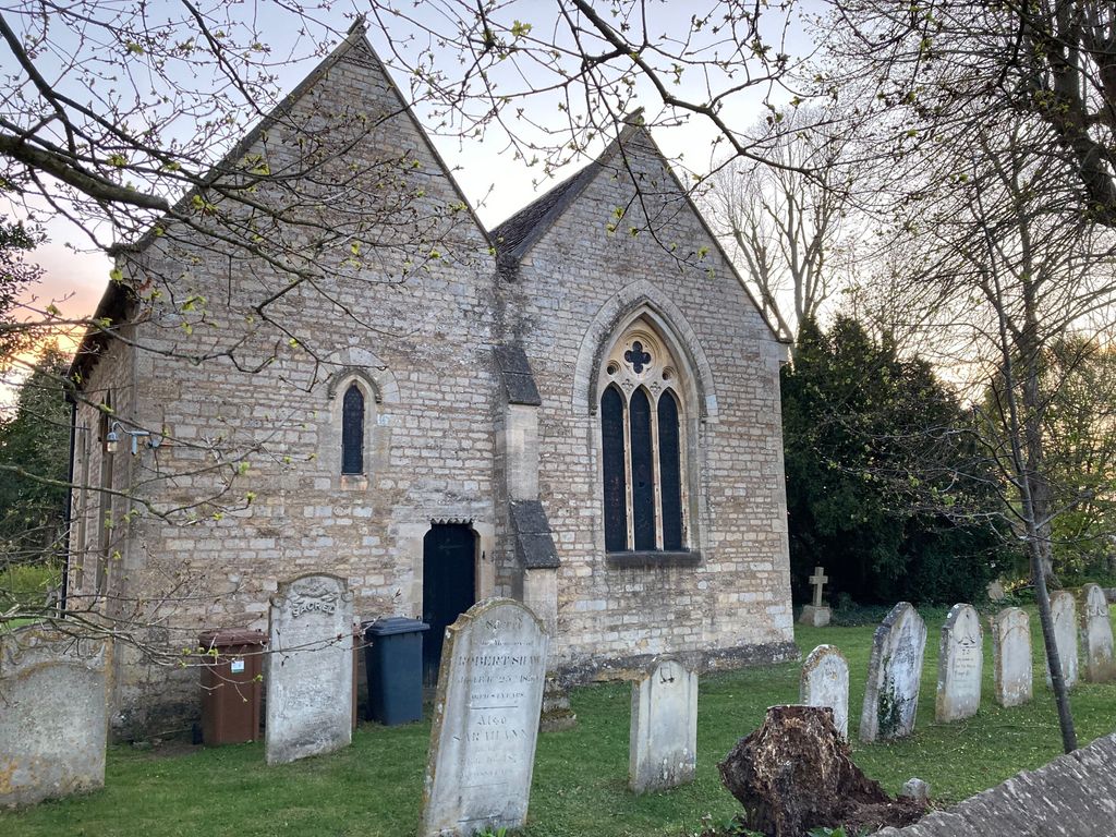
| Description | : | St Michael & All Angels was built in the 12th century as a chapel-of-ease to St Kyneburgha, Castor for the benefit of the villagers of Sutton and to serve the Peterborough Abbey Grange Farm and Manor in the village. The church was enlarged c1170 when the original South wall was removed, the two Norman arches erected and the South Aisle added. The Chantry Chapel (which now contains the Vestry and organ) added about 1225 was originally dedicated to St Giles, the patron saint of lepers and cripples. |
frequently asked questions (FAQ):
-
Where is St. Michael & All Angels?
St. Michael & All Angels is located at 2 Nene Way, Sutton, Peterborough, Cambs Sutton, Peterborough Unitary Authority ,Cambridgeshire , PE5 7XBEngland.
-
St. Michael & All Angels cemetery's updated grave count on graveviews.com?
0 memorials
-
Where are the coordinates of the St. Michael & All Angels?
Latitude: 52.5754356
Longitude: -0.3853515
Nearby Cemetories:
1. St John the Baptist Churchyard
Stibbington, Huntingdonshire District, England
Coordinate: 52.5748920, -0.3926720
2. St Remigius Churchyard
Water Newton, Huntingdonshire District, England
Coordinate: 52.5624550, -0.3656390
3. St Mary the Virgin Church
Wansford, Huntingdonshire District, England
Coordinate: 52.5805160, -0.4173890
4. Yarwell Anglican and Methodist Church
Yarwell, East Northamptonshire Borough, England
Coordinate: 52.5671280, -0.4216160
5. Nassington and Yarwell Cemetery
Yarwell, East Northamptonshire Borough, England
Coordinate: 52.5682373, -0.4263580
6. St Kyneburgha Churchyard
Castor, Peterborough Unitary Authority, England
Coordinate: 52.5729580, -0.3417630
7. Saint Mary the Virgin & All Saints Churchyard
Nassington, East Northamptonshire Borough, England
Coordinate: 52.5530000, -0.4332000
8. St. Michael's Churchyard
Chesterton, Huntingdonshire District, England
Coordinate: 52.5451434, -0.3400366
9. St. Andrew's Church
Alwalton, Huntingdonshire District, England
Coordinate: 52.5495800, -0.3297610
10. Alwalton Cemetery
Alwalton, Huntingdonshire District, England
Coordinate: 52.5501113, -0.3288831
11. All Saints Churchyard
Elton, Huntingdonshire District, England
Coordinate: 52.5320200, -0.4063200
12. All Saints Churchyard
Wittering, Peterborough Unitary Authority, England
Coordinate: 52.6058600, -0.4421600
13. St. Andrew's Churchyard
Ufford, Peterborough Unitary Authority, England
Coordinate: 52.6230210, -0.3864660
14. St Mary The Virgin Churchyard
Marholm, Peterborough Unitary Authority, England
Coordinate: 52.6029760, -0.3089570
15. St. John the Baptist Churchyard
Barnack, Peterborough Unitary Authority, England
Coordinate: 52.6324997, -0.4068000
16. St Mary the Virgin and All Saints Churchyard
Fotheringhay, East Northamptonshire Borough, England
Coordinate: 52.5258330, -0.4390740
17. Fotheringhay Castle
Fotheringhay, East Northamptonshire Borough, England
Coordinate: 52.5243170, -0.4363420
18. Barnack Bainton Road Cemetery
Barnack, Peterborough Unitary Authority, England
Coordinate: 52.6350291, -0.4069986
19. Peterborough Crematorium
Bretton, Peterborough Unitary Authority, England
Coordinate: 52.6047280, -0.2915090
20. St. Botolph Helpston Churchyard
Helpston, Peterborough Unitary Authority, England
Coordinate: 52.6359090, -0.3435870
21. St Mary's Churchyard
Bainton, Peterborough Unitary Authority, England
Coordinate: 52.6411500, -0.3838900
22. St. Mary's Churchyard
Peterborough, Peterborough Unitary Authority, England
Coordinate: 52.5184227, -0.3295881
23. Helpston Cemetery
Helpston, Peterborough Unitary Authority, England
Coordinate: 52.6374890, -0.3433900
24. St Mary Churchyard
Woodnewton, East Northamptonshire Borough, England
Coordinate: 52.5392210, -0.4795790