
| Memorials | : | 0 |
| Location | : | Peterborough, Peterborough Unitary Authority, England |
| Phone | : | +44 1733 242411 |
| Website | : | www.stiltonchurches.com/haddon-parish |
| Coordinate | : | 52.5184227, -0.3295881 |
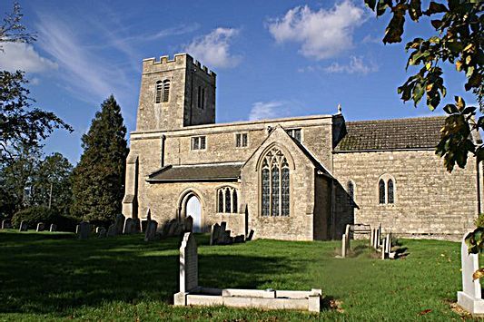
| Description | : | History There was a church mentioned at Haddon in the Domesday Survey of 1086. It is thought that the Eastern wall of the Nave belongs to that period. The church inside is bright and welcoming, especially when sunlight streams in through the south windows. The chancel arch is a very fine piece of work, with some nice carvings on the capitals. Arcades on the North and South sides were added in the early 13th Century. Over the chancel there are the fragments of a 15th Century wall painting that shows a figure seated on a rainbow. Close to the church... Read More |
frequently asked questions (FAQ):
-
Where is St. Mary's Churchyard?
St. Mary's Churchyard is located at Church Lane Peterborough, Peterborough Unitary Authority ,Cambridgeshire , PE7 3TREngland.
-
St. Mary's Churchyard cemetery's updated grave count on graveviews.com?
0 memorials
-
Where are the coordinates of the St. Mary's Churchyard?
Latitude: 52.5184227
Longitude: -0.3295881
Nearby Cemetories:
1. All Saints
Morborne, Huntingdonshire District, England
Coordinate: 52.5094990, -0.3228910
2. St. Michael's Churchyard
Chesterton, Huntingdonshire District, England
Coordinate: 52.5451434, -0.3400366
3. St. Andrew's Church
Alwalton, Huntingdonshire District, England
Coordinate: 52.5495800, -0.3297610
4. Alwalton Cemetery
Alwalton, Huntingdonshire District, England
Coordinate: 52.5501113, -0.3288831
5. Yaxley Cemetery
Peterborough, Peterborough Unitary Authority, England
Coordinate: 52.5137400, -0.2700500
6. Stilton Cemetery
Stilton, Huntingdonshire District, England
Coordinate: 52.4895230, -0.2923260
7. Saint Peter's Churchyard
Yaxley, Huntingdonshire District, England
Coordinate: 52.5117400, -0.2672200
8. All Saints Churchyard
Elton, Huntingdonshire District, England
Coordinate: 52.5320200, -0.4063200
9. St Remigius Churchyard
Water Newton, Huntingdonshire District, England
Coordinate: 52.5624550, -0.3656390
10. Saint Mary the Virgin Churchyard
Warmington, East Northamptonshire Borough, England
Coordinate: 52.5064111, -0.4144919
11. St Kyneburgha Churchyard
Castor, Peterborough Unitary Authority, England
Coordinate: 52.5729580, -0.3417630
12. All Saints at Botolphbridge (Not Extant)
Orton Longueville, Peterborough Unitary Authority, England
Coordinate: 52.5615344, -0.2731584
13. St Nicholas Churchyard
Glatton, Huntingdonshire District, England
Coordinate: 52.4607440, -0.3035450
14. Woodston Cemetery
Woodston, Peterborough Unitary Authority, England
Coordinate: 52.5607090, -0.2529700
15. St. Giles' Churchyard
Holme, Huntingdonshire District, England
Coordinate: 52.4767090, -0.2502880
16. Fotheringhay Castle
Fotheringhay, East Northamptonshire Borough, England
Coordinate: 52.5243170, -0.4363420
17. St. Michael & All Angels
Sutton, Peterborough Unitary Authority, England
Coordinate: 52.5754356, -0.3853515
18. St Mary the Virgin and All Saints Churchyard
Fotheringhay, East Northamptonshire Borough, England
Coordinate: 52.5258330, -0.4390740
19. St John the Baptist Churchyard
Stibbington, Huntingdonshire District, England
Coordinate: 52.5748920, -0.3926720
20. St. Margaret's churchyard
Fletton, Peterborough Unitary Authority, England
Coordinate: 52.5584400, -0.2350100
21. Stanground Cemetery
Stanground, Peterborough Unitary Authority, England
Coordinate: 52.5516860, -0.2273100
22. Holme Cemetery
Holme, Huntingdonshire District, England
Coordinate: 52.4726120, -0.2408410
23. Fletton Cemetery
Fletton, Peterborough Unitary Authority, England
Coordinate: 52.5611534, -0.2350550
24. Saint Mary the Virgin & All Saints Churchyard
Nassington, East Northamptonshire Borough, England
Coordinate: 52.5530000, -0.4332000