
| Memorials | : | 0 |
| Location | : | Bradford, Metropolitan Borough of Bradford, England |
| Coordinate | : | 53.7813052, -1.7849559 |
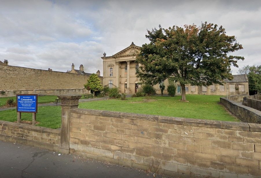
| Description | : | Built in 1814, near Hunt Yard, Great Horton, and opened in 1815, the church was originally a Wesleyan Methodist Chapel with roots going back to 1766. This grade 2 listed building is still in use today and is currently called the Cornerstone Methodist and United Reformed Church. An additional burial ground was made behind the church. |
frequently asked questions (FAQ):
-
Where is Great Horton Methodist Churchyard?
Great Horton Methodist Churchyard is located at 463 Great Horton Road, Great Horton, Bradford Bradford, Metropolitan Borough of Bradford ,West Yorkshire , BD7 3EREngland.
-
Great Horton Methodist Churchyard cemetery's updated grave count on graveviews.com?
0 memorials
-
Where are the coordinates of the Great Horton Methodist Churchyard?
Latitude: 53.7813052
Longitude: -1.7849559
Nearby Cemetories:
1. Friends Burial Ground
Bradford, Metropolitan Borough of Bradford, England
Coordinate: 53.7788470, -1.7747890
2. Scholemoor Cemetery and Crematorium
Bradford, Metropolitan Borough of Bradford, England
Coordinate: 53.7875404, -1.7963200
3. Zion Congregationalist Church Graveyard
Bradford, Metropolitan Borough of Bradford, England
Coordinate: 53.7681900, -1.7702550
4. St Stephen Churchyard
West Bowling, Metropolitan Borough of Bradford, England
Coordinate: 53.7783440, -1.7578570
5. Wibsey Salvation Army Memorial Garden
Wibsey, Metropolitan Borough of Bradford, England
Coordinate: 53.7664200, -1.7702900
6. St. Matthew Churchyard
Bradford, Metropolitan Borough of Bradford, England
Coordinate: 53.7689950, -1.7638640
7. St. Paul Churchyard
Wibsey, Metropolitan Borough of Bradford, England
Coordinate: 53.7636700, -1.7784700
8. Congregational Chapel
Bradford, Metropolitan Borough of Bradford, England
Coordinate: 53.7910653, -1.7567839
9. Clayton Baptist Churchyard
Clayton, Metropolitan Borough of Bradford, England
Coordinate: 53.7830600, -1.8192200
10. Toad Lane Presbyterian Chapel Graveyard
Bradford, Metropolitan Borough of Bradford, England
Coordinate: 53.7921690, -1.7543550
11. St John the Baptist Churchyard
Clayton, Metropolitan Borough of Bradford, England
Coordinate: 53.7836900, -1.8210500
12. Clayton Methodist Chapelyard
Clayton, Metropolitan Borough of Bradford, England
Coordinate: 53.7812800, -1.8232500
13. North Bierley Municipal Cemetery
Bradford, Metropolitan Borough of Bradford, England
Coordinate: 53.7584470, -1.7781560
14. Clayton Heights Methodist Chapelyard
Bradford, Metropolitan Borough of Bradford, England
Coordinate: 53.7705400, -1.8227400
15. East Brook Chapel
Bradford, Metropolitan Borough of Bradford, England
Coordinate: 53.7934570, -1.7464240
16. Bradford Cathedral
Bradford, Metropolitan Borough of Bradford, England
Coordinate: 53.7953600, -1.7479800
17. St. Michael & All Angels Churchyard
Shelf, Metropolitan Borough of Calderdale, England
Coordinate: 53.7573400, -1.8030500
18. St Paul Churchyard
Manningham, Metropolitan Borough of Bradford, England
Coordinate: 53.8069700, -1.7723700
19. Allerton Methodist Chapelyard
Bradford, Metropolitan Borough of Bradford, England
Coordinate: 53.8017410, -1.8158310
20. Pollard Family Burial Ground
Shelf, Metropolitan Borough of Calderdale, England
Coordinate: 53.7570244, -1.8072409
21. Bethel Methodist Chapelyard
Shelf, Metropolitan Borough of Calderdale, England
Coordinate: 53.7563530, -1.8079900
22. Daisy Hill Primitive Methodist Chapelyard
Bradford, Metropolitan Borough of Bradford, England
Coordinate: 53.8085600, -1.8007500
23. Holy Trinity Churchyard
Low Moor, Metropolitan Borough of Bradford, England
Coordinate: 53.7564900, -1.7590000
24. Witchfield Wesleyan Methodist Church
Shelf, Metropolitan Borough of Calderdale, England
Coordinate: 53.7559447, -1.8114241