| Memorials | : | 0 |
| Location | : | Bradford, Metropolitan Borough of Bradford, England |
| Coordinate | : | 53.7788470, -1.7747890 |
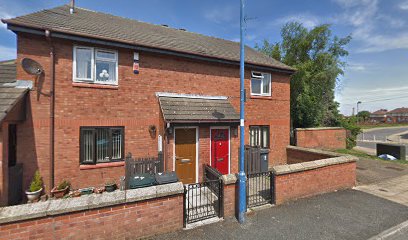
| Description | : | This was the first piece of land bought by the Quakers in Bradford area. It was located near Quaker Lane which was near Horton Park and Park Avenue Cricket Ground. It was bought around 1656 and used for burials for a few years. In 1835, the land was sold to John Hardy of Little Horton, a quarryman. Houses were built atop the graves and traces of the original burial ground have since disappeared under modern development. The map coordinates shown for this burial ground are approximate as the exact location of it has been obscured by modern development. A listing of individuals... Read More |
frequently asked questions (FAQ):
-
Where is Friends Burial Ground?
Friends Burial Ground is located at Bradford, Metropolitan Borough of Bradford ,West Yorkshire ,England.
-
Friends Burial Ground cemetery's updated grave count on graveviews.com?
0 memorials
-
Where are the coordinates of the Friends Burial Ground?
Latitude: 53.7788470
Longitude: -1.7747890
Nearby Cemetories:
1. Great Horton Methodist Churchyard
Bradford, Metropolitan Borough of Bradford, England
Coordinate: 53.7813052, -1.7849559
2. St Stephen Churchyard
West Bowling, Metropolitan Borough of Bradford, England
Coordinate: 53.7783440, -1.7578570
3. Zion Congregationalist Church Graveyard
Bradford, Metropolitan Borough of Bradford, England
Coordinate: 53.7681900, -1.7702550
4. St. Matthew Churchyard
Bradford, Metropolitan Borough of Bradford, England
Coordinate: 53.7689950, -1.7638640
5. Wibsey Salvation Army Memorial Garden
Wibsey, Metropolitan Borough of Bradford, England
Coordinate: 53.7664200, -1.7702900
6. St. Paul Churchyard
Wibsey, Metropolitan Borough of Bradford, England
Coordinate: 53.7636700, -1.7784700
7. Scholemoor Cemetery and Crematorium
Bradford, Metropolitan Borough of Bradford, England
Coordinate: 53.7875404, -1.7963200
8. Congregational Chapel
Bradford, Metropolitan Borough of Bradford, England
Coordinate: 53.7910653, -1.7567839
9. Toad Lane Presbyterian Chapel Graveyard
Bradford, Metropolitan Borough of Bradford, England
Coordinate: 53.7921690, -1.7543550
10. North Bierley Municipal Cemetery
Bradford, Metropolitan Borough of Bradford, England
Coordinate: 53.7584470, -1.7781560
11. East Brook Chapel
Bradford, Metropolitan Borough of Bradford, England
Coordinate: 53.7934570, -1.7464240
12. Bradford Cathedral
Bradford, Metropolitan Borough of Bradford, England
Coordinate: 53.7953600, -1.7479800
13. Bowling Cemetery
West Bowling, Metropolitan Borough of Bradford, England
Coordinate: 53.7714844, -1.7370390
14. Holy Trinity Churchyard
Low Moor, Metropolitan Borough of Bradford, England
Coordinate: 53.7564900, -1.7590000
15. St. John's Church, Bowling
Bradford, Metropolitan Borough of Bradford, England
Coordinate: 53.7827200, -1.7322190
16. St. John the Evangelist Churchyard
Bradford, Metropolitan Borough of Bradford, England
Coordinate: 53.7705297, -1.7323057
17. Clayton Baptist Churchyard
Clayton, Metropolitan Borough of Bradford, England
Coordinate: 53.7830600, -1.8192200
18. St. Michael & All Angels Churchyard
Shelf, Metropolitan Borough of Calderdale, England
Coordinate: 53.7573400, -1.8030500
19. St John the Baptist Churchyard
Clayton, Metropolitan Borough of Bradford, England
Coordinate: 53.7836900, -1.8210500
20. St Mark Churchyard
Low Moor, Metropolitan Borough of Bradford, England
Coordinate: 53.7512500, -1.7696100
21. Wesley Place Methodist Chapelyard
Low Moor, Metropolitan Borough of Bradford, England
Coordinate: 53.7528600, -1.7573100
22. St Paul Churchyard
Manningham, Metropolitan Borough of Bradford, England
Coordinate: 53.8069700, -1.7723700
23. Clayton Methodist Chapelyard
Clayton, Metropolitan Borough of Bradford, England
Coordinate: 53.7812800, -1.8232500
24. Pollard Family Burial Ground
Shelf, Metropolitan Borough of Calderdale, England
Coordinate: 53.7570244, -1.8072409

