
| Memorials | : | 0 |
| Location | : | Edgmond, Telford and Wrekin Unitary Authority, England |
| Coordinate | : | 52.7699680, -2.4159730 |
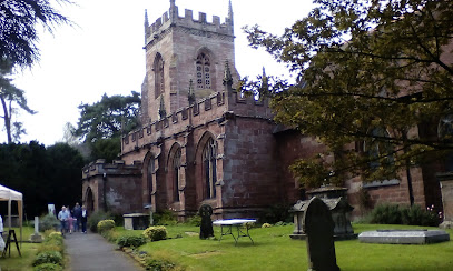
| Description | : | The existing church building of St Peter's dates from 1080. It is a Grade 1 listed building. It was enlarged in the 13th century and almost completely rebuilt during the following two centuries, re-using some 13th-century material. The church was restored in 1877–78 by G E Street. In the churchyard are several memorials including that of the Piggott family who were Rectors from 1699 to 1888. This is the monument on the west side of the church that has a particularly tall cross with the statues of four Apostles at the foot of it, and the Apostles’ Creed is... Read More |
frequently asked questions (FAQ):
-
Where is St. Peter Church?
St. Peter Church is located at Edgmond, Telford and Wrekin Unitary Authority ,Shropshire ,England.
-
St. Peter Church cemetery's updated grave count on graveviews.com?
0 memorials
-
Where are the coordinates of the St. Peter Church?
Latitude: 52.7699680
Longitude: -2.4159730
Nearby Cemetories:
1. Talbot Chapel
Longford, Telford and Wrekin Unitary Authority, England
Coordinate: 52.7627400, -2.4081500
2. St. Nicholas Churchyard
Newport, Telford and Wrekin Unitary Authority, England
Coordinate: 52.7696720, -2.3793420
3. Saint Michael and All Angels
Chetwynd, Telford and Wrekin Unitary Authority, England
Coordinate: 52.7887300, -2.3935160
4. St Andrews Churchyard
Church Aston, Telford and Wrekin Unitary Authority, England
Coordinate: 52.7577930, -2.3815770
5. Chetwynd Churchyard
Newport, Telford and Wrekin Unitary Authority, England
Coordinate: 52.7905280, -2.3916390
6. Newport General Cemetery
Newport, Telford and Wrekin Unitary Authority, England
Coordinate: 52.7656260, -2.3655840
7. Forton All Saints Churchyard
Newport, Telford and Wrekin Unitary Authority, England
Coordinate: 52.7876210, -2.3640430
8. St Michael and All Angels Churchyard
Lilleshall, Telford and Wrekin Unitary Authority, England
Coordinate: 52.7345610, -2.4032770
9. Tibberton All Saints
Tibberton, Telford and Wrekin Unitary Authority, England
Coordinate: 52.7800660, -2.4741020
10. Lilleshall Abbey
Lilleshall, Telford and Wrekin Unitary Authority, England
Coordinate: 52.7247000, -2.3898000
11. Woodcote Parish Church
Woodcote, Telford and Wrekin Unitary Authority, England
Coordinate: 52.7358330, -2.3456640
12. St. Matthew's Churchyard
Donnington Wood, Telford and Wrekin Unitary Authority, England
Coordinate: 52.7148135, -2.4308853
13. Holy Trinity Church
Wrockwardine, Telford and Wrekin Unitary Authority, England
Coordinate: 52.7105800, -2.4476600
14. Wrockwardine Wood Methodist Graveyard
Wrockwardine, Telford and Wrekin Unitary Authority, England
Coordinate: 52.7076180, -2.4426530
15. St Oswald's Church Burial Ground
Hinstock, Shropshire Unitary Authority, England
Coordinate: 52.8346100, -2.4577700
16. Church of St Peter
Norbury, Stafford Borough, England
Coordinate: 52.8084000, -2.3184000
17. St Mary's, Moreton
Moreton, Stafford Borough, England
Coordinate: 52.7521490, -2.3021420
18. St Michael & All Angels
Childs Ercall, Shropshire Unitary Authority, England
Coordinate: 52.8222524, -2.4975524
19. Wombridge Cemetery
Oakengates, Telford and Wrekin Unitary Authority, England
Coordinate: 52.7023940, -2.4579990
20. St Mary's & St Leonard's Church Burial Ground
Wombridge, Telford and Wrekin Unitary Authority, England
Coordinate: 52.7014856, -2.4585662
21. Saint Catherine Churchyard
Eyton upon the Weald Moors, Telford and Wrekin Unitary Authority, England
Coordinate: 52.7299800, -2.5182200
22. Hadley Cemetery
Leegomery, Telford and Wrekin Unitary Authority, England
Coordinate: 52.7097110, -2.4893660
23. St George's Churchyard
Oakengates, Telford and Wrekin Unitary Authority, England
Coordinate: 52.6952150, -2.4321740
24. Telford Crematorium
Redhill, Telford and Wrekin Unitary Authority, England
Coordinate: 52.6950750, -2.3988090