
| Memorials | : | 0 |
| Location | : | Moreton, Stafford Borough, England |
| Phone | : | 01785822820 |
| Website | : | www.achurchnearyou.com/church/4233 |
| Coordinate | : | 52.7521490, -2.3021420 |
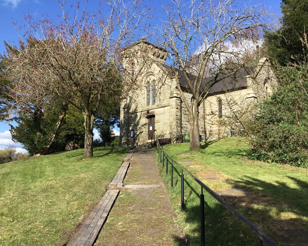
| Description | : | The tiny Anglican church of St. Mary's, Moreton, stands atop a steep hill alongside Church Lane in the Shropshire/Staffordshire border village of Moreton, which nowadays is barely larger than a hamlet. Moreton has traditionally been on the Staffordshire side of the border, barely, with its church being part of the Diocese of Lichfield, but its postcode is a Telford and Wrekin one. It's easiest to access as follows: From the Staffordshire side: Follow the A518 into Gnosall, then break left down Wharf Rd at the Royal Oak and follow it all the way to the bridge over the Shropshire Union... Read More |
frequently asked questions (FAQ):
-
Where is St Mary's, Moreton?
St Mary's, Moreton is located at Church Lane, Moreton, Staffordshire, England Moreton, Stafford Borough ,Staffordshire , TF10 9DSEngland.
-
St Mary's, Moreton cemetery's updated grave count on graveviews.com?
0 memorials
-
Where are the coordinates of the St Mary's, Moreton?
Latitude: 52.7521490
Longitude: -2.3021420
Nearby Cemetories:
1. Woodcote Parish Church
Woodcote, Telford and Wrekin Unitary Authority, England
Coordinate: 52.7358330, -2.3456640
2. Newport General Cemetery
Newport, Telford and Wrekin Unitary Authority, England
Coordinate: 52.7656260, -2.3655840
3. St. Lawrence Churchyard
Gnosall, Stafford Borough, England
Coordinate: 52.7853010, -2.2533270
4. St. Editha's Parish Church Graveyard
Church Eaton, Stafford Borough, England
Coordinate: 52.7560690, -2.2259540
5. St Andrews Churchyard
Church Aston, Telford and Wrekin Unitary Authority, England
Coordinate: 52.7577930, -2.3815770
6. St. Nicholas Churchyard
Newport, Telford and Wrekin Unitary Authority, England
Coordinate: 52.7696720, -2.3793420
7. Forton All Saints Churchyard
Newport, Telford and Wrekin Unitary Authority, England
Coordinate: 52.7876210, -2.3640430
8. Church of St Peter
Norbury, Stafford Borough, England
Coordinate: 52.8084000, -2.3184000
9. St Andrew Church
Weston-under-Lizard, South Staffordshire Borough, England
Coordinate: 52.6932000, -2.2883000
10. Lilleshall Abbey
Lilleshall, Telford and Wrekin Unitary Authority, England
Coordinate: 52.7247000, -2.3898000
11. St Michael and All Angels Churchyard
Lilleshall, Telford and Wrekin Unitary Authority, England
Coordinate: 52.7345610, -2.4032770
12. Talbot Chapel
Longford, Telford and Wrekin Unitary Authority, England
Coordinate: 52.7627400, -2.4081500
13. Saint Michael and All Angels
Chetwynd, Telford and Wrekin Unitary Authority, England
Coordinate: 52.7887300, -2.3935160
14. Chetwynd Churchyard
Newport, Telford and Wrekin Unitary Authority, England
Coordinate: 52.7905280, -2.3916390
15. St Giles Churchyard
Haughton, Stafford Borough, England
Coordinate: 52.7817750, -2.2005140
16. St. Peter Church
Edgmond, Telford and Wrekin Unitary Authority, England
Coordinate: 52.7699680, -2.4159730
17. Ronton Priory
Ellenhall, Stafford Borough, England
Coordinate: 52.8157600, -2.2414900
18. St Mary and All Saints
Bradley, Stafford Borough, England
Coordinate: 52.7599257, -2.1808769
19. All Saints Churchyard
Lapley, South Staffordshire Borough, England
Coordinate: 52.7138900, -2.1902330
20. Saint Johns Church
Bishops Wood, Shropshire Unitary Authority, England
Coordinate: 52.6810030, -2.2369880
21. Telford Crematorium
Redhill, Telford and Wrekin Unitary Authority, England
Coordinate: 52.6950750, -2.3988090
22. Ranton All Saints
Ranton, Stafford Borough, England
Coordinate: 52.8151300, -2.2156400
23. St. Matthew's Churchyard
Donnington Wood, Telford and Wrekin Unitary Authority, England
Coordinate: 52.7148135, -2.4308853
24. White Ladies Priory
Boscobel, Shropshire Unitary Authority, England
Coordinate: 52.6657000, -2.2584000